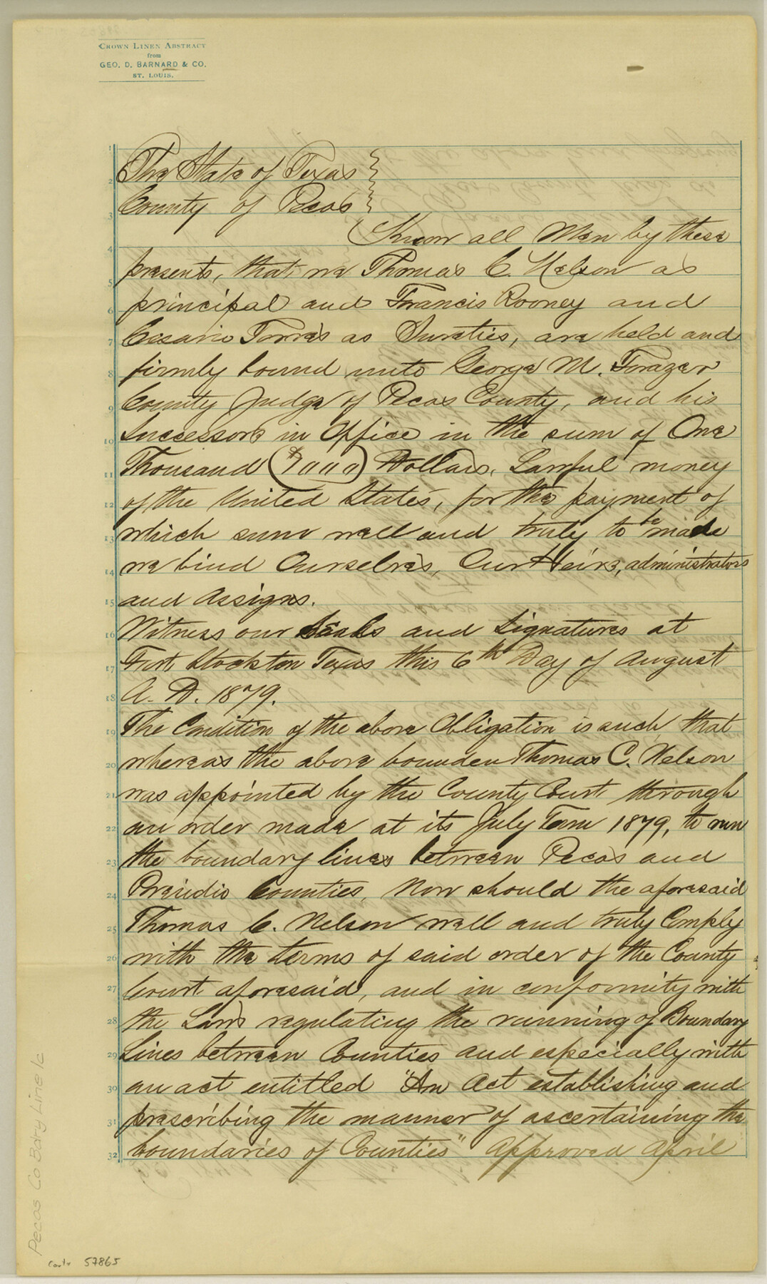
Pecos County Boundary File 1c
[Bond Certificate; Affidavit of County Surveyor]
-
Map/Doc
57865
-
Collection
General Map Collection
-
Counties
Pecos
-
Subjects
County Boundaries
-
Height x Width
14.2 x 8.5 inches
36.1 x 21.6 cm
Part of: General Map Collection
Key to Photo Index Sheets of Texas Coast Portion

Print $20.00
- Digital $50.00
Key to Photo Index Sheets of Texas Coast Portion
1954
Size 20.0 x 24.0 inches
Map/Doc 83436
Lavaca County Sketch File 9

Print $22.00
- Digital $50.00
Lavaca County Sketch File 9
Size 7.2 x 13.4 inches
Map/Doc 29646
Kimble County Rolled Sketch 31

Print $20.00
- Digital $50.00
Kimble County Rolled Sketch 31
Size 21.1 x 27.4 inches
Map/Doc 6521
Sutton County Working Sketch 17

Print $20.00
- Digital $50.00
Sutton County Working Sketch 17
1975
Size 34.0 x 27.2 inches
Map/Doc 62360
Lampasas County Boundary File 16

Print $14.00
- Digital $50.00
Lampasas County Boundary File 16
Size 8.9 x 8.2 inches
Map/Doc 56216
Hunt County Working Sketch 9

Print $20.00
- Digital $50.00
Hunt County Working Sketch 9
1959
Size 33.8 x 30.6 inches
Map/Doc 66356
Interfaith's Official Map: The Woodlands, a real hometown for people and companies

Interfaith's Official Map: The Woodlands, a real hometown for people and companies
1997
Size 36.7 x 22.5 inches
Map/Doc 94285
Map of Jack County

Print $40.00
- Digital $50.00
Map of Jack County
1895
Size 49.7 x 37.2 inches
Map/Doc 16858
Burnet County Sketch File 14

Print $4.00
- Digital $50.00
Burnet County Sketch File 14
Size 15.1 x 8.9 inches
Map/Doc 16698
Railroad Track Map, H&TCRRCo., Falls County, Texas

Print $4.00
- Digital $50.00
Railroad Track Map, H&TCRRCo., Falls County, Texas
1918
Size 11.3 x 18.5 inches
Map/Doc 62847
Upshur County Working Sketch 4

Print $20.00
- Digital $50.00
Upshur County Working Sketch 4
1939
Size 21.6 x 15.3 inches
Map/Doc 69560
[Surveys by Brown in Austin's Little Colony along the Colorado River and Walnut Creek]
![196, [Surveys by Brown in Austin's Little Colony along the Colorado River and Walnut Creek], General Map Collection](https://historictexasmaps.com/wmedia_w700/maps/196.tif.jpg)
Print $20.00
- Digital $50.00
[Surveys by Brown in Austin's Little Colony along the Colorado River and Walnut Creek]
1832
Size 33.2 x 23.3 inches
Map/Doc 196
You may also like
Dallam County Sketch File 2

Print $260.00
- Digital $50.00
Dallam County Sketch File 2
1886
Size 29.9 x 17.4 inches
Map/Doc 11278
Grimes County Working Sketch 14

Print $20.00
- Digital $50.00
Grimes County Working Sketch 14
1983
Size 33.0 x 34.1 inches
Map/Doc 63305
Atascosa County Working Sketch 33

Print $20.00
- Digital $50.00
Atascosa County Working Sketch 33
1982
Size 16.7 x 13.6 inches
Map/Doc 67229
McMullen County Sketch File 43

Print $10.00
- Digital $50.00
McMullen County Sketch File 43
1942
Size 14.2 x 8.8 inches
Map/Doc 31421
Kinney County Rolled Sketch 17

Print $20.00
- Digital $50.00
Kinney County Rolled Sketch 17
1965
Size 18.4 x 21.5 inches
Map/Doc 6544
Jeff Davis County Sketch File 4

Print $42.00
- Digital $50.00
Jeff Davis County Sketch File 4
1889
Size 12.5 x 14.7 inches
Map/Doc 27893
Flight Mission No. CRC-5R, Frame 38, Chambers County

Print $20.00
- Digital $50.00
Flight Mission No. CRC-5R, Frame 38, Chambers County
1956
Size 18.6 x 22.3 inches
Map/Doc 84957
Flight Mission No. DQN-7K, Frame 91, Calhoun County

Print $20.00
- Digital $50.00
Flight Mission No. DQN-7K, Frame 91, Calhoun County
1953
Size 18.4 x 22.2 inches
Map/Doc 84482
Edwards County Working Sketch 106

Print $20.00
- Digital $50.00
Edwards County Working Sketch 106
1972
Size 32.3 x 26.5 inches
Map/Doc 68982
Flight Mission No. BRA-8M, Frame 85, Jefferson County

Print $20.00
- Digital $50.00
Flight Mission No. BRA-8M, Frame 85, Jefferson County
1953
Size 18.7 x 22.3 inches
Map/Doc 85605
Brazoria County Rolled Sketch 19

Print $20.00
- Digital $50.00
Brazoria County Rolled Sketch 19
Size 16.9 x 19.0 inches
Map/Doc 5166
Young County Sketch File 12

Print $4.00
- Digital $50.00
Young County Sketch File 12
1889
Size 8.5 x 13.6 inches
Map/Doc 40876