Presidio County Boundary File 3
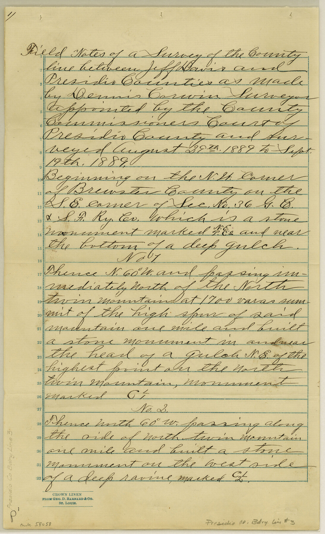
Certified Copy of Field Notes of A Survey of the county Line between Jeff Davis County and Presidio Co. Texas
-
Map/Doc
58058
-
Collection
General Map Collection
-
Counties
Presidio
-
Subjects
County Boundaries
-
Height x Width
14.1 x 8.5 inches
35.8 x 21.6 cm
Part of: General Map Collection
Trinity River, Terrell Sheet/Kings Creek

Print $20.00
- Digital $50.00
Trinity River, Terrell Sheet/Kings Creek
1930
Size 42.3 x 19.7 inches
Map/Doc 65229
Dawson County Working Sketch 16

Print $20.00
- Digital $50.00
Dawson County Working Sketch 16
1956
Size 13.9 x 18.8 inches
Map/Doc 68560
Pecos County Rolled Sketch 150

Print $20.00
- Digital $50.00
Pecos County Rolled Sketch 150
1958
Size 27.6 x 24.7 inches
Map/Doc 7280
Flight Mission No. DCL-3C, Frame 155, Kenedy County

Print $20.00
- Digital $50.00
Flight Mission No. DCL-3C, Frame 155, Kenedy County
1943
Size 18.6 x 22.4 inches
Map/Doc 85803
Parker County Sketch File 9

Print $4.00
- Digital $50.00
Parker County Sketch File 9
Size 8.1 x 10.0 inches
Map/Doc 33538
[Corpus Christi Bay, Padre Island, Mustang Island, Laguna de la Madre, King and Kenedy's Pasture]
![73046, [Corpus Christi Bay, Padre Island, Mustang Island, Laguna de la Madre, King and Kenedy's Pasture], General Map Collection](https://historictexasmaps.com/wmedia_w700/maps/73046.tif.jpg)
Print $20.00
- Digital $50.00
[Corpus Christi Bay, Padre Island, Mustang Island, Laguna de la Madre, King and Kenedy's Pasture]
Size 26.4 x 18.2 inches
Map/Doc 73046
Plat of Division 3 of Day Ranch Lands, Leaday, Texas

Print $20.00
- Digital $50.00
Plat of Division 3 of Day Ranch Lands, Leaday, Texas
Size 20.4 x 21.8 inches
Map/Doc 81514
Newton County Working Sketch 10

Print $20.00
- Digital $50.00
Newton County Working Sketch 10
1941
Size 17.1 x 21.6 inches
Map/Doc 71256
El Paso County Boundary File 11

Print $58.00
- Digital $50.00
El Paso County Boundary File 11
Size 9.3 x 6.5 inches
Map/Doc 53125
United States, 1956 Revised Edition

Print $40.00
- Digital $50.00
United States, 1956 Revised Edition
1946
Size 48.0 x 36.3 inches
Map/Doc 78631
Crockett County Working Sketch 73

Print $20.00
- Digital $50.00
Crockett County Working Sketch 73
1963
Size 38.8 x 33.8 inches
Map/Doc 68406

You may also like
Map of Wood County

Print $20.00
- Digital $50.00
Map of Wood County
1877
Size 16.8 x 17.1 inches
Map/Doc 4168
Pecos County Working Sketch 103

Print $40.00
- Digital $50.00
Pecos County Working Sketch 103
1971
Size 43.4 x 51.4 inches
Map/Doc 71576
Randall County

Print $20.00
- Digital $50.00
Randall County
1958
Size 41.0 x 33.0 inches
Map/Doc 77402
[East half of Crockett County]
![92997, [East half of Crockett County], Twichell Survey Records](https://historictexasmaps.com/wmedia_w700/maps/92997-1.tif.jpg)
Print $20.00
- Digital $50.00
[East half of Crockett County]
Size 15.2 x 21.9 inches
Map/Doc 92997
Uvalde County Working Sketch 34

Print $20.00
- Digital $50.00
Uvalde County Working Sketch 34
1963
Size 31.6 x 42.8 inches
Map/Doc 72104
Concho County Working Sketch 25

Print $20.00
- Digital $50.00
Concho County Working Sketch 25
1982
Size 32.3 x 38.1 inches
Map/Doc 68207
Working Sketch in Matagorda County

Print $20.00
- Digital $50.00
Working Sketch in Matagorda County
1890
Size 36.6 x 22.7 inches
Map/Doc 4479
Overlay For Flight Mission No. BRE-2P, Frame 110 of H. A. Pierce Corrected Survey, December 21, 1950 of Cyrus Egery Survey of June 15, 1855

Print $20.00
- Digital $50.00
Overlay For Flight Mission No. BRE-2P, Frame 110 of H. A. Pierce Corrected Survey, December 21, 1950 of Cyrus Egery Survey of June 15, 1855
1956
Size 18.3 x 20.4 inches
Map/Doc 86795

Map of Jackson County

Print $20.00
- Digital $50.00
Map of Jackson County
1840
Size 34.9 x 25.3 inches
Map/Doc 3707
Leon County Sketch File 12

Print $23.00
- Digital $50.00
Leon County Sketch File 12
1886
Size 9.5 x 11.5 inches
Map/Doc 29765
Index sheet to accompany map of survey for connecting the inland waters along margin of the Gulf of Mexico from Donaldsonville in Louisiana to the Rio Grande River in Texas

Print $20.00
- Digital $50.00
Index sheet to accompany map of survey for connecting the inland waters along margin of the Gulf of Mexico from Donaldsonville in Louisiana to the Rio Grande River in Texas
Size 18.2 x 27.5 inches
Map/Doc 72691