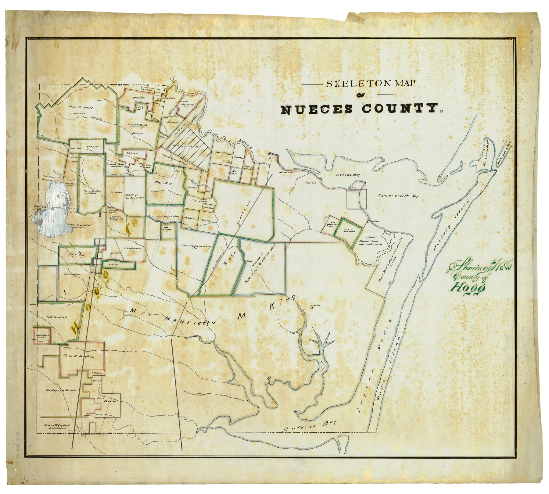
Skeleton Map of Nueces County
-
Map/Doc
592
-
Collection
Maddox Collection
-
Counties
Nueces Jim Hogg
-
Height x Width
35.5 x 39.4 inches
90.2 x 100.1 cm
Part of: Maddox Collection
Hansford County, Texas

Print $20.00
- Digital $50.00
Hansford County, Texas
1888
Size 22.6 x 18.6 inches
Map/Doc 5033
Guadalupe County, Texas

Print $20.00
- Digital $50.00
Guadalupe County, Texas
1880
Size 24.7 x 22.5 inches
Map/Doc 491
Midland County, Texas

Print $20.00
- Digital $50.00
Midland County, Texas
1880
Size 25.5 x 21.5 inches
Map/Doc 740
Map of Tyler County, Texas

Print $20.00
- Digital $50.00
Map of Tyler County, Texas
1881
Size 22.3 x 24.2 inches
Map/Doc 762
Copy of Sketch in Nacogdoches Scrip 1392

Print $20.00
- Digital $50.00
Copy of Sketch in Nacogdoches Scrip 1392
1890
Size 25.3 x 14.7 inches
Map/Doc 75780
Castro County, Texas

Print $20.00
- Digital $50.00
Castro County, Texas
1891
Size 24.5 x 20.4 inches
Map/Doc 694
Revised Sectional Map No. 6 showing land surveys in parts of Presidio and Brewster Counties, Texas

Print $20.00
- Digital $50.00
Revised Sectional Map No. 6 showing land surveys in parts of Presidio and Brewster Counties, Texas
Size 24.2 x 23.0 inches
Map/Doc 4475
Jasper County

Print $20.00
- Digital $50.00
Jasper County
1882
Size 17.6 x 14.0 inches
Map/Doc 75779
Map of survey 189, T. C. R.R. Co. in Travis County, Texas

Print $20.00
- Digital $50.00
Map of survey 189, T. C. R.R. Co. in Travis County, Texas
1915
Size 18.6 x 15.2 inches
Map/Doc 78479
Hunt County, Texas

Print $20.00
- Digital $50.00
Hunt County, Texas
1871
Size 25.8 x 19.4 inches
Map/Doc 462
Map of Washington County, Texas

Print $20.00
- Digital $50.00
Map of Washington County, Texas
1879
Size 14.4 x 21.6 inches
Map/Doc 765
Callahan County, Texas

Print $20.00
- Digital $50.00
Callahan County, Texas
1880
Size 24.1 x 18.5 inches
Map/Doc 89276
You may also like
San Jacinto County Working Sketch 24

Print $20.00
- Digital $50.00
San Jacinto County Working Sketch 24
1942
Size 23.1 x 38.2 inches
Map/Doc 63737
Typical Scenes of Wichita Falls and District

Print $20.00
- Digital $50.00
Typical Scenes of Wichita Falls and District
1927
Size 13.7 x 16.6 inches
Map/Doc 96761
Hudspeth County Sketch File 54

Print $4.00
- Digital $50.00
Hudspeth County Sketch File 54
1993
Size 8.9 x 14.2 inches
Map/Doc 27079

Brooks County Working Sketch 5

Print $20.00
- Digital $50.00
Brooks County Working Sketch 5
1906
Size 29.8 x 16.3 inches
Map/Doc 67789
Flight Mission No. BRA-8M, Frame 122, Jefferson County

Print $20.00
- Digital $50.00
Flight Mission No. BRA-8M, Frame 122, Jefferson County
1953
Size 18.5 x 22.4 inches
Map/Doc 85618
The Republic County of Jackson. January 29, 1842

Print $20.00
The Republic County of Jackson. January 29, 1842
2020
Size 15.6 x 21.8 inches
Map/Doc 96189
Flight Mission No. DIX-10P, Frame 167, Aransas County

Print $20.00
- Digital $50.00
Flight Mission No. DIX-10P, Frame 167, Aransas County
1956
Size 18.6 x 22.3 inches
Map/Doc 83957
Presidio County Working Sketch 91

Print $40.00
- Digital $50.00
Presidio County Working Sketch 91
1974
Size 42.0 x 59.4 inches
Map/Doc 71768
Sketch Showing Boundary Between Randall and Deaf Smith Counties

Print $20.00
- Digital $50.00
Sketch Showing Boundary Between Randall and Deaf Smith Counties
Size 13.4 x 33.3 inches
Map/Doc 91832
Jefferson County Sketch File 40

Print $16.00
- Digital $50.00
Jefferson County Sketch File 40
1947
Size 12.3 x 7.9 inches
Map/Doc 28228
Kinney County

Print $40.00
- Digital $50.00
Kinney County
1955
Size 48.9 x 42.4 inches
Map/Doc 77342