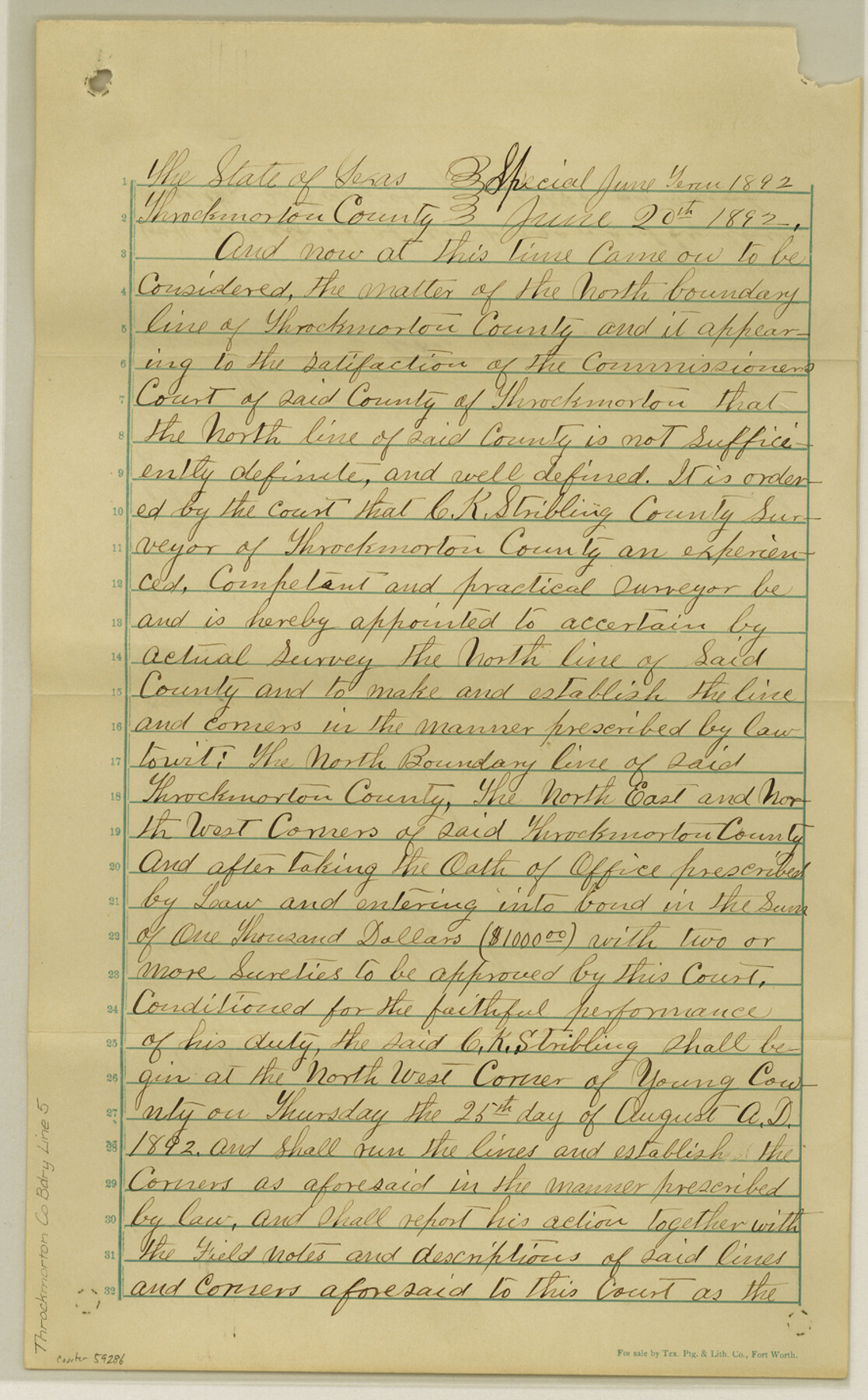
Throckmorton County Boundary File 5
Certificate of Bond filed May 29th, 93
-
Map/Doc
59286
-
Collection
General Map Collection
-
Counties
Throckmorton
-
Subjects
County Boundaries
-
Height x Width
14.3 x 8.9 inches
36.3 x 22.6 cm
Part of: General Map Collection

![94159, Austin Street Map [Verso], General Map Collection](https://historictexasmaps.com/wmedia_w700/maps/94159.tif.jpg)
Hardeman County

Print $20.00
- Digital $50.00
Hardeman County
1935
Size 42.8 x 40.0 inches
Map/Doc 77302
Flight Mission No. BRA-6M, Frame 82, Jefferson County

Print $20.00
- Digital $50.00
Flight Mission No. BRA-6M, Frame 82, Jefferson County
1953
Size 18.5 x 22.3 inches
Map/Doc 85426
Flight Mission No. CUG-3P, Frame 83, Kleberg County

Print $20.00
- Digital $50.00
Flight Mission No. CUG-3P, Frame 83, Kleberg County
1956
Size 18.7 x 22.4 inches
Map/Doc 86258
Map of the World on a Globular Projection to illustrate Olney's school geography

Print $20.00
- Digital $50.00
Map of the World on a Globular Projection to illustrate Olney's school geography
1844
Size 12.1 x 19.0 inches
Map/Doc 93535
Wise County Sketch File A

Print $8.00
- Digital $50.00
Wise County Sketch File A
1884
Size 9.1 x 8.1 inches
Map/Doc 40609
San Antonio Bay and Vicinity in Aransas and Calhoun Counties, showing Subdivsion for Mineral Development

Print $40.00
- Digital $50.00
San Antonio Bay and Vicinity in Aransas and Calhoun Counties, showing Subdivsion for Mineral Development
1948
Size 37.0 x 74.5 inches
Map/Doc 1912
Chambers County Sketch File 9

Print $10.00
- Digital $50.00
Chambers County Sketch File 9
1872
Size 10.3 x 11.8 inches
Map/Doc 17546
Crockett County Sketch File 57

Print $22.00
- Digital $50.00
Crockett County Sketch File 57
Size 12.2 x 8.9 inches
Map/Doc 19832
Menard County Working Sketch 4

Print $20.00
- Digital $50.00
Menard County Working Sketch 4
1914
Size 19.8 x 16.2 inches
Map/Doc 70951
Flight Mission No. DQO-3K, Frame 14, Galveston County

Print $20.00
- Digital $50.00
Flight Mission No. DQO-3K, Frame 14, Galveston County
1952
Size 18.8 x 22.4 inches
Map/Doc 85055
You may also like
Red River, Bois D'Arc Creek Floodway Sheet No. 7

Print $20.00
- Digital $50.00
Red River, Bois D'Arc Creek Floodway Sheet No. 7
1917
Size 29.0 x 23.8 inches
Map/Doc 69662
Flight Mission No. DIX-10P, Frame 79, Aransas County

Print $20.00
- Digital $50.00
Flight Mission No. DIX-10P, Frame 79, Aransas County
1956
Size 18.8 x 22.3 inches
Map/Doc 83940
South Sulphur River, Harpers Crossing Sheet

Print $20.00
- Digital $50.00
South Sulphur River, Harpers Crossing Sheet
1925
Size 23.3 x 18.0 inches
Map/Doc 78328
Trinity County

Print $20.00
- Digital $50.00
Trinity County
1882
Size 17.1 x 24.6 inches
Map/Doc 4097
Right of Way and Track Map, Texas & New Orleans R.R. Co. operated by the T. & N. O. R.R. Co., Dallas-Sabine Branch

Print $40.00
- Digital $50.00
Right of Way and Track Map, Texas & New Orleans R.R. Co. operated by the T. & N. O. R.R. Co., Dallas-Sabine Branch
1918
Size 24.6 x 56.4 inches
Map/Doc 64631
Armstrong County Boundary File 1c

Print $10.00
- Digital $50.00
Armstrong County Boundary File 1c
Size 14.1 x 8.7 inches
Map/Doc 50132
Mason County Working Sketch 15

Print $40.00
- Digital $50.00
Mason County Working Sketch 15
1976
Size 61.9 x 45.4 inches
Map/Doc 70851
Travis County Working Sketch 13

Print $20.00
- Digital $50.00
Travis County Working Sketch 13
1930
Size 20.5 x 27.3 inches
Map/Doc 69397
Borden County Sketch File 2

Print $40.00
- Digital $50.00
Borden County Sketch File 2
Size 19.4 x 10.3 inches
Map/Doc 10932
Van Zandt County Rolled Sketch 7

Print $20.00
- Digital $50.00
Van Zandt County Rolled Sketch 7
1946
Size 27.0 x 20.4 inches
Map/Doc 8147
Stephens County Working Sketch 33

Print $20.00
- Digital $50.00
Stephens County Working Sketch 33
1978
Size 31.1 x 30.8 inches
Map/Doc 63976
Map of Drum, Oyster & Bastrop Bays & vicinity in Brazoria County showing subdivision for mineral development

Print $20.00
- Digital $50.00
Map of Drum, Oyster & Bastrop Bays & vicinity in Brazoria County showing subdivision for mineral development
Size 36.8 x 47.3 inches
Map/Doc 65808