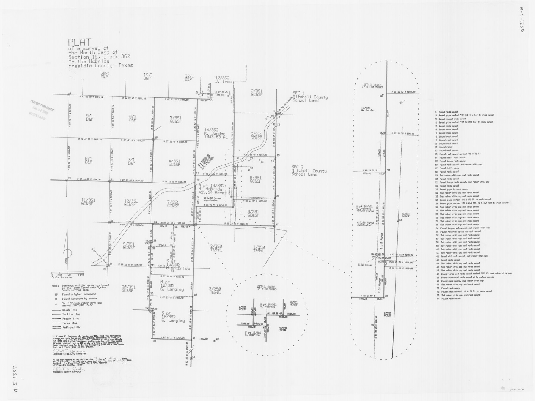
Plat of a survey of the North part of section 16, Block 362, Martha McBride, Presidio County, Texas
N-2-122
-
Map/Doc
60521
-
Collection
General Map Collection
-
Object Dates
1989 (Creation Date)
-
Counties
Presidio
-
Height x Width
25.5 x 35.0 inches
64.8 x 88.9 cm
Part of: General Map Collection
Flight Mission No. DAG-23K, Frame 61, Matagorda County

Print $20.00
- Digital $50.00
Flight Mission No. DAG-23K, Frame 61, Matagorda County
1953
Size 16.0 x 15.7 inches
Map/Doc 86488
Marble Falls City, Burnet County, Texas

Print $20.00
- Digital $50.00
Marble Falls City, Burnet County, Texas
1890
Size 26.6 x 20.5 inches
Map/Doc 4830
Webb County Working Sketch 3

Print $20.00
- Digital $50.00
Webb County Working Sketch 3
1906
Size 18.2 x 27.2 inches
Map/Doc 72368
Hamilton County Working Sketch 1

Print $20.00
- Digital $50.00
Hamilton County Working Sketch 1
1914
Size 17.7 x 17.8 inches
Map/Doc 63339
Southern Part of Laguna Madre

Print $20.00
- Digital $50.00
Southern Part of Laguna Madre
1975
Size 45.1 x 35.0 inches
Map/Doc 73545
Jackson County Sketch File 29

Print $10.00
- Digital $50.00
Jackson County Sketch File 29
Size 13.4 x 8.7 inches
Map/Doc 27725
Harris County Working Sketch 48

Print $20.00
- Digital $50.00
Harris County Working Sketch 48
1943
Size 26.8 x 16.0 inches
Map/Doc 65940
Old Miscellaneous File 27c

Print $18.00
- Digital $50.00
Old Miscellaneous File 27c
1880
Size 14.1 x 8.6 inches
Map/Doc 75727
Kaufman County Sketch File 10

Print $4.00
- Digital $50.00
Kaufman County Sketch File 10
1873
Size 10.2 x 8.2 inches
Map/Doc 28643
Galveston County Rolled Sketch 29

Print $104.00
- Digital $50.00
Galveston County Rolled Sketch 29
Size 10.1 x 15.3 inches
Map/Doc 45147
Blanco County Sketch File 11

Print $4.00
- Digital $50.00
Blanco County Sketch File 11
Size 4.0 x 7.6 inches
Map/Doc 14590
Galveston Island, showing division into lots

Print $40.00
- Digital $50.00
Galveston Island, showing division into lots
1839
Size 76.9 x 33.3 inches
Map/Doc 2036
You may also like
Flight Mission No. DQN-5K, Frame 148, Calhoun County

Print $20.00
- Digital $50.00
Flight Mission No. DQN-5K, Frame 148, Calhoun County
1953
Size 18.6 x 21.9 inches
Map/Doc 84423
[Working Sketch in Martin County Showing Northwest Portion of County]
![91355, [Working Sketch in Martin County Showing Northwest Portion of County], Twichell Survey Records](https://historictexasmaps.com/wmedia_w700/maps/91355-1.tif.jpg)
Print $20.00
- Digital $50.00
[Working Sketch in Martin County Showing Northwest Portion of County]
1902
Size 17.1 x 36.0 inches
Map/Doc 91355
[Archer County School Land]
![90324, [Archer County School Land], Twichell Survey Records](https://historictexasmaps.com/wmedia_w700/maps/90324-1.tif.jpg)
Print $20.00
- Digital $50.00
[Archer County School Land]
Size 21.7 x 16.7 inches
Map/Doc 90324
Brazoria County Working Sketch 22

Print $20.00
- Digital $50.00
Brazoria County Working Sketch 22
1959
Size 27.0 x 25.3 inches
Map/Doc 67507
Nora Jane Wilson Lease

Print $20.00
- Digital $50.00
Nora Jane Wilson Lease
1952
Size 12.5 x 15.0 inches
Map/Doc 92962
Hudspeth County Sketch File 52

Print $100.00
- Digital $50.00
Hudspeth County Sketch File 52
1983
Size 10.9 x 31.2 inches
Map/Doc 11807
La Salle County Rolled Sketch 12

Print $20.00
- Digital $50.00
La Salle County Rolled Sketch 12
Size 25.3 x 37.2 inches
Map/Doc 6575
Working Sketch, Garza County

Print $20.00
- Digital $50.00
Working Sketch, Garza County
1904
Size 13.9 x 14.7 inches
Map/Doc 92693
North Sulphur River, Mt. Joy Sheet

Print $20.00
- Digital $50.00
North Sulphur River, Mt. Joy Sheet
1926
Size 33.7 x 40.9 inches
Map/Doc 65166
Shelby County Rolled Sketch 16

Print $20.00
- Digital $50.00
Shelby County Rolled Sketch 16
1935
Size 33.0 x 43.8 inches
Map/Doc 9925
[Surveys along the Salado and Lampasas Rivers and Saltillo Creek]
![362, [Surveys along the Salado and Lampasas Rivers and Saltillo Creek], General Map Collection](https://historictexasmaps.com/wmedia_w700/maps/362.tif.jpg)
Print $2.00
- Digital $50.00
[Surveys along the Salado and Lampasas Rivers and Saltillo Creek]
1845
Size 13.1 x 7.8 inches
Map/Doc 362
