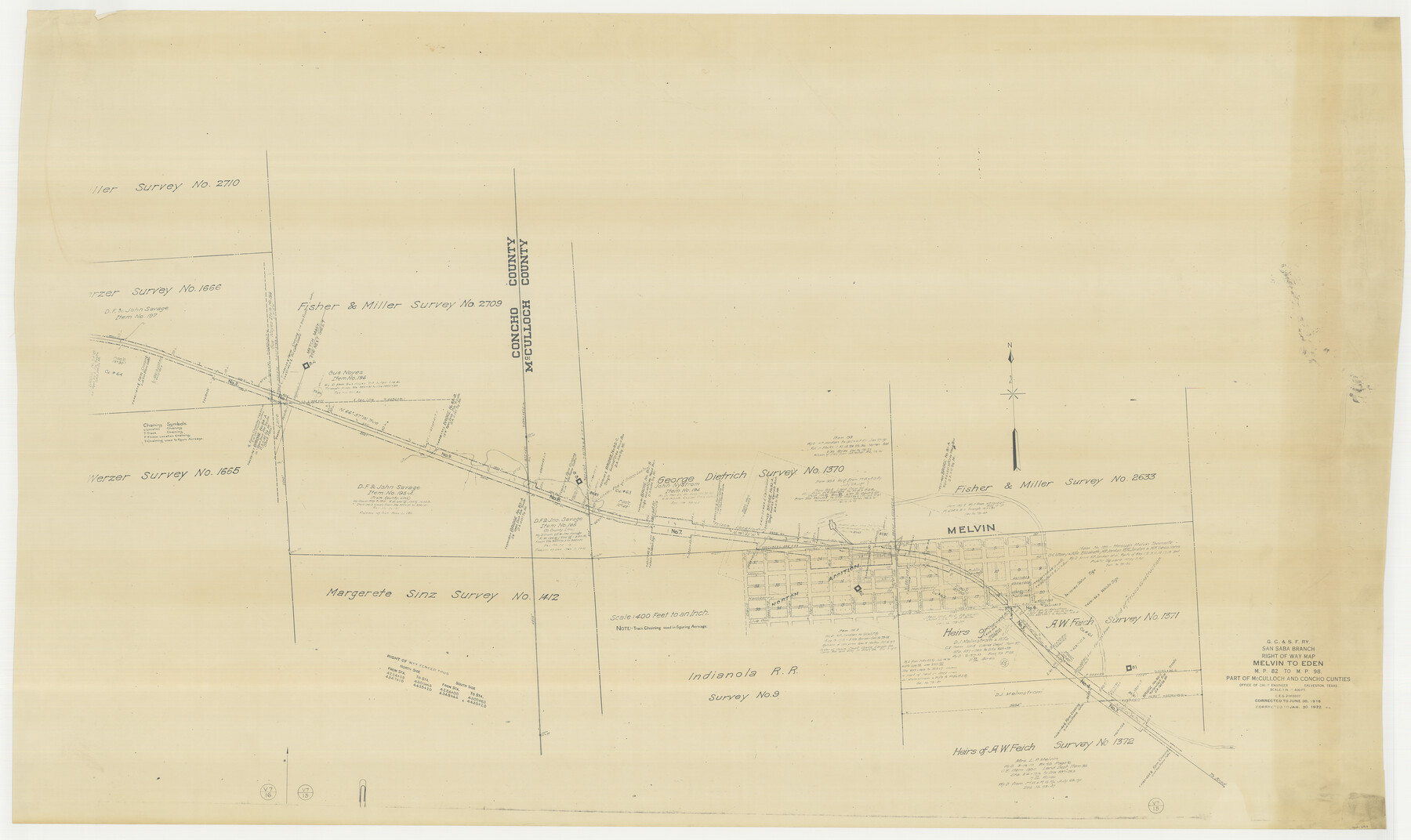
G. C. & S. F. Ry., San Saba Branch Right of Way Map, Melvin to Eden
M.P. 82 to M.P. 98
Z-2-220, N.1.46
-
Map/Doc
61417
-
Collection
General Map Collection
-
Object Dates
1922/1/30 (Revision Date)
1916/6/30 (Creation Date)
-
People and Organizations
Office of Chief Engineer (Publisher)
-
Counties
McCulloch Concho
-
Subjects
Railroads
-
Height x Width
37.6 x 63.1 inches
95.5 x 160.3 cm
-
Medium
paper, photocopy
-
Scale
1 inch = 400 feet
-
Features
GC&SF
Brady Creek
Melvin
Part of: General Map Collection
Flight Mission No. CRK-5P, Frame 123, Refugio County

Print $20.00
- Digital $50.00
Flight Mission No. CRK-5P, Frame 123, Refugio County
1956
Size 18.4 x 22.1 inches
Map/Doc 86926
Anderson County Working Sketch 39

Print $20.00
- Digital $50.00
Anderson County Working Sketch 39
1986
Size 21.6 x 21.8 inches
Map/Doc 67039
Flight Mission No. BRA-16M, Frame 60, Jefferson County

Print $20.00
- Digital $50.00
Flight Mission No. BRA-16M, Frame 60, Jefferson County
1953
Size 18.6 x 22.3 inches
Map/Doc 85677
Washington County Working Sketch 2

Print $20.00
- Digital $50.00
Washington County Working Sketch 2
1981
Size 23.6 x 20.1 inches
Map/Doc 72363
Harris County Working Sketch 71

Print $20.00
- Digital $50.00
Harris County Working Sketch 71
1957
Size 26.8 x 42.3 inches
Map/Doc 65963
Maps of Gulf Intracoastal Waterway, Texas - Sabine River to the Rio Grande and connecting waterways including ship channels

Print $20.00
- Digital $50.00
Maps of Gulf Intracoastal Waterway, Texas - Sabine River to the Rio Grande and connecting waterways including ship channels
1966
Size 14.6 x 22.3 inches
Map/Doc 61930
Sutton County Working Sketch 44

Print $20.00
- Digital $50.00
Sutton County Working Sketch 44
1951
Size 29.8 x 27.5 inches
Map/Doc 62387
Connected Map of Austin's Colony

Print $20.00
- Digital $50.00
Connected Map of Austin's Colony
1833
Size 38.1 x 36.1 inches
Map/Doc 88999
Galveston County NRC Article 33.136 Sketch 80

Print $24.00
- Digital $50.00
Galveston County NRC Article 33.136 Sketch 80
2014
Size 36.0 x 24.0 inches
Map/Doc 94987
1882 Map of the Texas & Pacific R-Y Reserve

Print $20.00
- Digital $50.00
1882 Map of the Texas & Pacific R-Y Reserve
1887
Size 44.6 x 29.8 inches
Map/Doc 83561
[Sketch for Mineral Application 27669 - Trinity River, Frank R. Graves]
![2858, [Sketch for Mineral Application 27669 - Trinity River, Frank R. Graves], General Map Collection](https://historictexasmaps.com/wmedia_w700/maps/2858-1.tif.jpg)
Print $40.00
- Digital $50.00
[Sketch for Mineral Application 27669 - Trinity River, Frank R. Graves]
1934
Size 28.3 x 83.2 inches
Map/Doc 2858
Montgomery County Working Sketch 11

Print $20.00
- Digital $50.00
Montgomery County Working Sketch 11
1933
Size 25.2 x 17.7 inches
Map/Doc 71118
You may also like
Runnels County Working Sketch 33

Print $20.00
- Digital $50.00
Runnels County Working Sketch 33
Size 26.5 x 22.6 inches
Map/Doc 63631
Zapata County Sketch File 12

Print $20.00
- Digital $50.00
Zapata County Sketch File 12
1918
Size 15.6 x 33.0 inches
Map/Doc 12721
Atascosa County Rolled Sketch 9

Print $20.00
- Digital $50.00
Atascosa County Rolled Sketch 9
1905
Size 34.5 x 26.9 inches
Map/Doc 5093
Throckmorton County Sketch File 4

Print $40.00
- Digital $50.00
Throckmorton County Sketch File 4
Size 15.1 x 15.2 inches
Map/Doc 38054
Matagorda County NRC Article 33.136 Sketch 24

Print $78.00
Matagorda County NRC Article 33.136 Sketch 24
2025
Map/Doc 97509
Hemphill County Rolled Sketch 17

Print $20.00
- Digital $50.00
Hemphill County Rolled Sketch 17
1965
Size 27.8 x 36.1 inches
Map/Doc 6197
Upshur County Boundary File 1

Print $30.00
- Digital $50.00
Upshur County Boundary File 1
Size 9.4 x 8.6 inches
Map/Doc 59500
Brazoria County Working Sketch 6

Print $20.00
- Digital $50.00
Brazoria County Working Sketch 6
1922
Size 16.8 x 24.0 inches
Map/Doc 67491
[Surveys in the Bexar District along the Colorado River]
![38, [Surveys in the Bexar District along the Colorado River], General Map Collection](https://historictexasmaps.com/wmedia_w700/maps/38.tif.jpg)
Print $2.00
- Digital $50.00
[Surveys in the Bexar District along the Colorado River]
1841
Size 7.2 x 9.1 inches
Map/Doc 38
Map showing the environs of Brazos Island, Texas

Print $20.00
- Digital $50.00
Map showing the environs of Brazos Island, Texas
Size 18.1 x 25.0 inches
Map/Doc 72926
Upton County Sketch File 14a

Print $18.00
- Digital $50.00
Upton County Sketch File 14a
1927
Size 14.5 x 9.1 inches
Map/Doc 38864
Hockley County Sketch File 8

Print $20.00
- Digital $50.00
Hockley County Sketch File 8
Size 35.0 x 26.2 inches
Map/Doc 11771