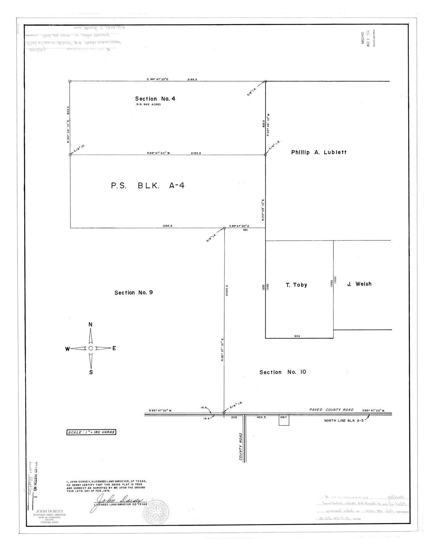
Hartley County Rolled Sketch 8
[Plat of section 4, Block A-4, Public School Land]
-
Map/Doc
6162
-
Collection
General Map Collection
-
Object Dates
2/14/1974 (Creation Date)
3/7/1974 (File Date)
-
People and Organizations
John Dorsey (Surveyor/Engineer)
-
Counties
Hartley
-
Subjects
Surveying Rolled Sketch
-
Height x Width
20.0 x 23.7 inches
50.8 x 60.2 cm
-
Scale
1" = 180 varas
Part of: General Map Collection
Harris County Working Sketch 59

Print $20.00
- Digital $50.00
Harris County Working Sketch 59
1953
Size 36.9 x 24.8 inches
Map/Doc 65951
Lubbock County Sketch File 6

Print $20.00
- Digital $50.00
Lubbock County Sketch File 6
1902
Size 33.0 x 20.8 inches
Map/Doc 12017
Nacogdoches County Sketch File 13

Print $6.00
- Digital $50.00
Nacogdoches County Sketch File 13
1883
Size 14.2 x 8.7 inches
Map/Doc 32256
Victoria County Rolled Sketch 4B

Print $40.00
- Digital $50.00
Victoria County Rolled Sketch 4B
1963
Size 65.3 x 43.3 inches
Map/Doc 10096
Martin County Working Sketch 5

Print $20.00
- Digital $50.00
Martin County Working Sketch 5
1971
Size 42.9 x 31.0 inches
Map/Doc 70823
[Sketch for Mineral Application 16700 - Pecos River Bed]
![2811, [Sketch for Mineral Application 16700 - Pecos River Bed], General Map Collection](https://historictexasmaps.com/wmedia_w700/maps/2811.tif.jpg)
Print $20.00
- Digital $50.00
[Sketch for Mineral Application 16700 - Pecos River Bed]
1927
Size 20.6 x 28.6 inches
Map/Doc 2811
Kimble County Sketch File 4

Print $8.00
- Digital $50.00
Kimble County Sketch File 4
1847
Size 7.9 x 12.1 inches
Map/Doc 28912
Galveston Harbor, Texas

Print $20.00
- Digital $50.00
Galveston Harbor, Texas
1882
Size 15.0 x 19.5 inches
Map/Doc 97281
Hunt County Rolled Sketch 1

Print $20.00
- Digital $50.00
Hunt County Rolled Sketch 1
Size 28.3 x 18.4 inches
Map/Doc 6266
Hartley County Sketch File 16

Print $4.00
- Digital $50.00
Hartley County Sketch File 16
Size 11.1 x 7.1 inches
Map/Doc 26113
Cottle County Sketch File 3

Print $4.00
- Digital $50.00
Cottle County Sketch File 3
Size 10.0 x 8.4 inches
Map/Doc 19457
Menard County Working Sketch 26

Print $20.00
- Digital $50.00
Menard County Working Sketch 26
1961
Size 28.6 x 36.1 inches
Map/Doc 70973
You may also like
Wilbarger County Rolled Sketch 6

Print $20.00
- Digital $50.00
Wilbarger County Rolled Sketch 6
1885
Size 20.3 x 28.0 inches
Map/Doc 8256
Baylor County

Print $20.00
- Digital $50.00
Baylor County
1917
Size 47.3 x 40.7 inches
Map/Doc 66712
San Patricio County Sketch File 55

Print $14.00
- Digital $50.00
San Patricio County Sketch File 55
1999
Size 11.3 x 8.8 inches
Map/Doc 36394
Texas Intracoastal Waterway, Aransas Bay to Aransas Pass

Print $20.00
- Digital $50.00
Texas Intracoastal Waterway, Aransas Bay to Aransas Pass
1962
Size 26.8 x 38.7 inches
Map/Doc 73438
Bailey County Working Sketch Graphic Index

Print $20.00
- Digital $50.00
Bailey County Working Sketch Graphic Index
1956
Size 47.7 x 30.5 inches
Map/Doc 76460
Comanche County Working Sketch 5

Print $20.00
- Digital $50.00
Comanche County Working Sketch 5
1919
Size 31.8 x 28.9 inches
Map/Doc 68139
Description of Best Route from Austin to San Antonio, Texas

Print $20.00
Description of Best Route from Austin to San Antonio, Texas
1865
Size 12.9 x 13.1 inches
Map/Doc 79296
Reagan County Rolled Sketch 19

Print $20.00
- Digital $50.00
Reagan County Rolled Sketch 19
1939
Size 24.0 x 20.5 inches
Map/Doc 7445
Harris County Sketch File 12

Print $40.00
- Digital $50.00
Harris County Sketch File 12
1896
Size 16.1 x 12.5 inches
Map/Doc 25353
Henderson County Rolled Sketch 9

Print $40.00
- Digital $50.00
Henderson County Rolled Sketch 9
1963
Size 51.9 x 33.8 inches
Map/Doc 9165
Travis County

Print $40.00
- Digital $50.00
Travis County
1963
Size 37.7 x 50.7 inches
Map/Doc 73597
San Patricio County Sketch File 15A

Print $4.00
San Patricio County Sketch File 15A
1883
Size 11.0 x 8.5 inches
Map/Doc 97195