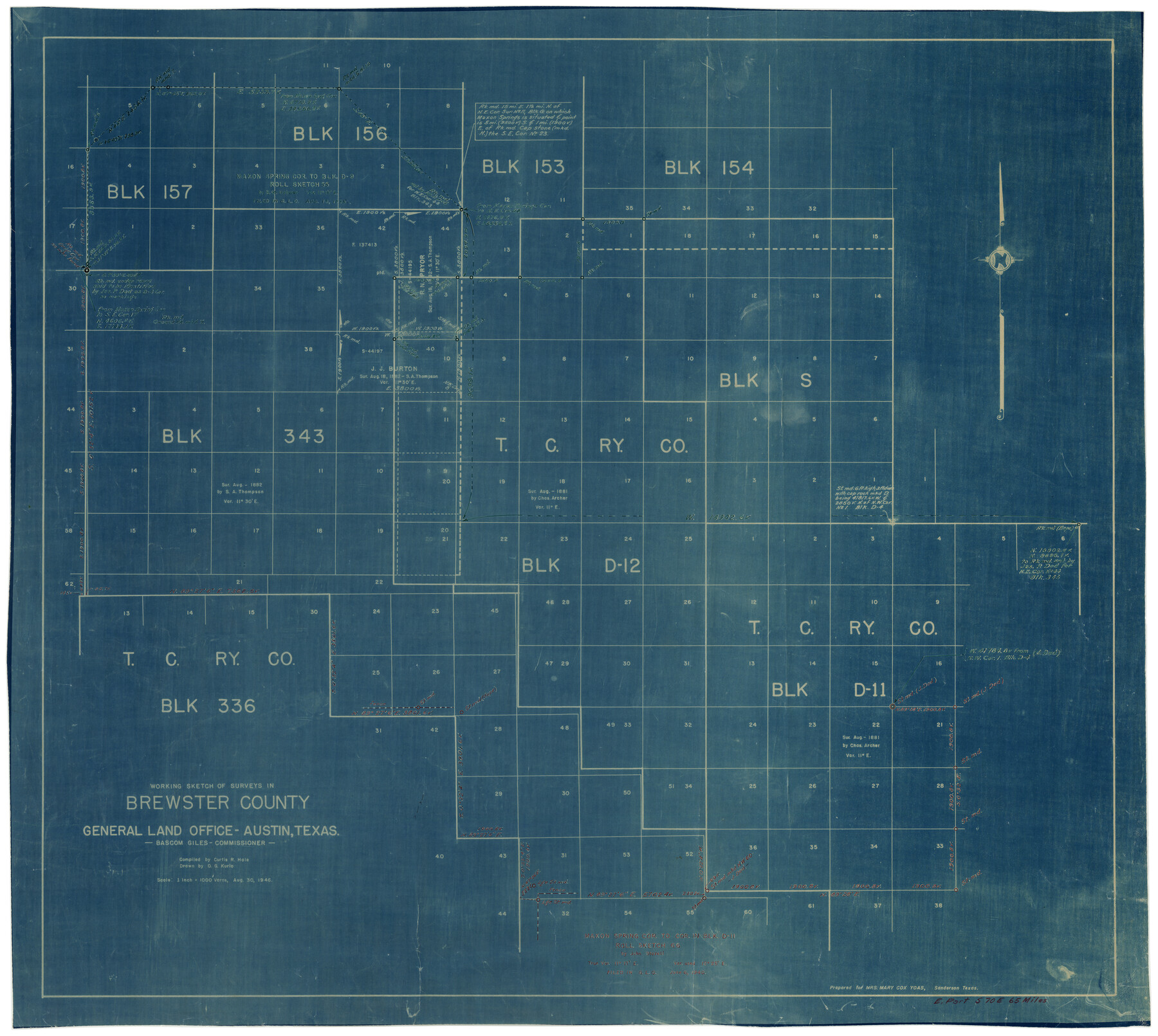
Brewster County Rolled Sketch 66
Working Sketch of Surveys in Brewster County [showing Maxon Spring Cor. to Cor. in Blk. D-11, Roll Sketch 66]
-
Map/Doc
61785
-
Collection
General Map Collection
-
Object Dates
8/30/1946 (Creation Date)
-
People and Organizations
John Stovell (Surveyor/Engineer)
Curtis R. Hale (Compiler)
Otto G. Kurio (Draftsman)
-
Counties
Brewster
-
Subjects
Surveying Rolled Sketch
-
Height x Width
33.0 x 36.2 inches
83.8 x 92.0 cm
-
Medium
blueprint
-
Comments
For another sheet, see 8490.
Related maps
Brewster County Rolled Sketch 66

Print $20.00
- Digital $50.00
Brewster County Rolled Sketch 66
1940
Size 33.0 x 36.2 inches
Map/Doc 8490
Part of: General Map Collection
Upshur County Working Sketch 16, revised

Print $20.00
- Digital $50.00
Upshur County Working Sketch 16, revised
1997
Size 42.9 x 37.2 inches
Map/Doc 69574
Coke County Boundary File 5

Print $36.00
- Digital $50.00
Coke County Boundary File 5
Size 7.7 x 37.9 inches
Map/Doc 51606
Estes Quadrangle

Print $20.00
- Digital $50.00
Estes Quadrangle
1971
Size 27.8 x 23.6 inches
Map/Doc 73442
Flight Mission No. DAH-17M, Frame 29, Orange County

Print $20.00
- Digital $50.00
Flight Mission No. DAH-17M, Frame 29, Orange County
1953
Size 18.7 x 22.5 inches
Map/Doc 86892
Gregg County Rolled Sketch 9A

Print $20.00
- Digital $50.00
Gregg County Rolled Sketch 9A
1932
Size 38.1 x 30.2 inches
Map/Doc 6035
Houston County Working Sketch 34

Print $40.00
- Digital $50.00
Houston County Working Sketch 34
Size 50.9 x 37.3 inches
Map/Doc 66264
Brewster County Rolled Sketch 101

Print $40.00
- Digital $50.00
Brewster County Rolled Sketch 101
1927
Size 74.7 x 50.4 inches
Map/Doc 10649
Flight Mission No. CRC-3R, Frame 37, Chambers County

Print $20.00
- Digital $50.00
Flight Mission No. CRC-3R, Frame 37, Chambers County
1956
Size 18.6 x 22.4 inches
Map/Doc 84810
Blanco County Sketch File 48

Print $6.00
- Digital $50.00
Blanco County Sketch File 48
1952
Size 11.7 x 9.0 inches
Map/Doc 14688
Real County Working Sketch 46

Print $20.00
- Digital $50.00
Real County Working Sketch 46
1956
Size 21.2 x 18.9 inches
Map/Doc 71938
Webb County Rolled Sketch EF2

Print $20.00
- Digital $50.00
Webb County Rolled Sketch EF2
1932
Size 40.4 x 29.9 inches
Map/Doc 8224
Bandera County Sketch File 34

Print $6.00
- Digital $50.00
Bandera County Sketch File 34
1987
Size 14.1 x 8.7 inches
Map/Doc 14030
You may also like
Flight Mission No. DCL-7C, Frame 67, Kenedy County

Print $20.00
- Digital $50.00
Flight Mission No. DCL-7C, Frame 67, Kenedy County
1943
Size 15.5 x 15.3 inches
Map/Doc 86053
Val Verde County Working Sketch Graphic Index, Sheet 2 (Sketches 26 to 88)

Print $20.00
- Digital $50.00
Val Verde County Working Sketch Graphic Index, Sheet 2 (Sketches 26 to 88)
1944
Size 40.3 x 36.4 inches
Map/Doc 76725
Aransas County Rolled Sketch 26

Print $20.00
- Digital $50.00
Aransas County Rolled Sketch 26
1984
Size 18.3 x 24.4 inches
Map/Doc 5060
Flight Mission No. DQN-2K, Frame 92, Calhoun County

Print $20.00
- Digital $50.00
Flight Mission No. DQN-2K, Frame 92, Calhoun County
1953
Size 18.6 x 22.2 inches
Map/Doc 84282
Houston including Bellaire, Bunker Hill, Galena Park, Hedwig, Hilshire, Hunters Creek, Jacinto City, Jersey Village, Missouri City, Pasadena, Piney Point, South Houston, Spring Valley, West University Place and adjoining communities [Recto]
![94179, Houston including Bellaire, Bunker Hill, Galena Park, Hedwig, Hilshire, Hunters Creek, Jacinto City, Jersey Village, Missouri City, Pasadena, Piney Point, South Houston, Spring Valley, West University Place and adjoining communities [Recto], General Map Collection](https://historictexasmaps.com/wmedia_w700/maps/94179.tif.jpg)
Houston including Bellaire, Bunker Hill, Galena Park, Hedwig, Hilshire, Hunters Creek, Jacinto City, Jersey Village, Missouri City, Pasadena, Piney Point, South Houston, Spring Valley, West University Place and adjoining communities [Recto]
Size 27.1 x 42.6 inches
Map/Doc 94179
General Highway Map. Detail of Cities and Towns in Leon County, Texas

Print $20.00
General Highway Map. Detail of Cities and Towns in Leon County, Texas
1961
Size 18.1 x 24.8 inches
Map/Doc 79569
[North line of Sherman, Hansford, Ochiltree and Lipscomb Counties]
![93189, [North line of Sherman, Hansford, Ochiltree and Lipscomb Counties], Twichell Survey Records](https://historictexasmaps.com/wmedia_w700/maps/93189-1.tif.jpg)
Print $40.00
- Digital $50.00
[North line of Sherman, Hansford, Ochiltree and Lipscomb Counties]
Size 127.0 x 14.3 inches
Map/Doc 93189
[Map Showing Surveys in Dimmit & La Salle Counties, Texas]
![75791, [Map Showing Surveys in Dimmit & La Salle Counties, Texas], Maddox Collection](https://historictexasmaps.com/wmedia_w700/maps/75791.tif.jpg)
Print $20.00
- Digital $50.00
[Map Showing Surveys in Dimmit & La Salle Counties, Texas]
Size 29.5 x 29.5 inches
Map/Doc 75791
San Jacinto County Sketch File 22

Print $136.00
San Jacinto County Sketch File 22
1935
Size 11.3 x 8.7 inches
Map/Doc 35734
Map of north end of Brazos Island

Print $20.00
- Digital $50.00
Map of north end of Brazos Island
1845
Size 24.2 x 18.3 inches
Map/Doc 72920

Flight Mission No. DIX-8P, Frame 88, Aransas County

Print $20.00
- Digital $50.00
Flight Mission No. DIX-8P, Frame 88, Aransas County
1956
Size 18.6 x 22.3 inches
Map/Doc 83913