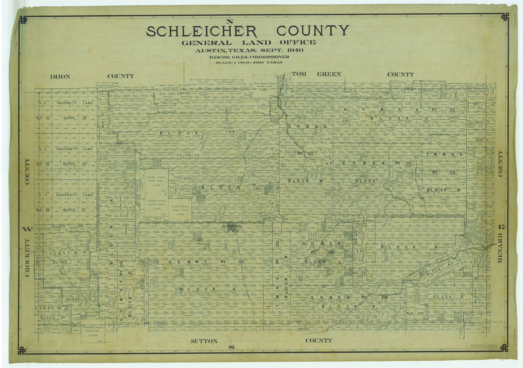
Schleicher County
-
Map/Doc
63028
-
Collection
General Map Collection
-
Object Dates
1940 (Creation Date)
-
People and Organizations
Texas General Land Office (Publisher)
Bascom Giles (GLO Commissioner)
J.L. Woodland (Compiler)
-
Counties
Schleicher
-
Subjects
County
-
Height x Width
39.4 x 56.0 inches
100.1 x 142.2 cm
-
Comments
Traced by Eltea Armstrong.
Part of: General Map Collection
McLennan County Sketch File 41

Print $44.00
- Digital $50.00
McLennan County Sketch File 41
1963
Size 11.1 x 8.6 inches
Map/Doc 31319
Right of Way & Track Map, St. Louis, Brownsville & Mexico Ry. operated by St. Louis, Brownsville & Mexico Ry. Co.

Print $40.00
- Digital $50.00
Right of Way & Track Map, St. Louis, Brownsville & Mexico Ry. operated by St. Louis, Brownsville & Mexico Ry. Co.
1919
Size 25.6 x 57.1 inches
Map/Doc 64616

Freestone County Boundary File 30

Print $8.00
- Digital $50.00
Freestone County Boundary File 30
Size 10.7 x 8.3 inches
Map/Doc 53588
Harris County Rolled Sketch P58

Print $20.00
- Digital $50.00
Harris County Rolled Sketch P58
1929
Size 29.4 x 37.7 inches
Map/Doc 9119
Red River County Working Sketch 53

Print $20.00
- Digital $50.00
Red River County Working Sketch 53
1971
Size 23.4 x 26.9 inches
Map/Doc 72036
Flight Mission No. CGI-4N, Frame 184, Cameron County

Print $20.00
- Digital $50.00
Flight Mission No. CGI-4N, Frame 184, Cameron County
1955
Size 18.7 x 22.3 inches
Map/Doc 84687
Chambers County Rolled Sketch 20

Print $1171.00
- Digital $50.00
Chambers County Rolled Sketch 20
Size 10.7 x 16.2 inches
Map/Doc 43987
Medina County Sketch File 7

Print $20.00
- Digital $50.00
Medina County Sketch File 7
Size 25.0 x 10.6 inches
Map/Doc 12067
A sketch of the map of the Land Dist. of Liberty

Print $2.00
- Digital $50.00
A sketch of the map of the Land Dist. of Liberty
Size 6.3 x 3.9 inches
Map/Doc 353
Bandera County Boundary File 4a

Print $32.00
- Digital $50.00
Bandera County Boundary File 4a
Size 13.3 x 8.7 inches
Map/Doc 50276
Jasper County Rolled Sketch 6

Print $20.00
- Digital $50.00
Jasper County Rolled Sketch 6
1948
Size 27.8 x 43.7 inches
Map/Doc 6353
You may also like
Dimmit County Working Sketch 48

Print $40.00
- Digital $50.00
Dimmit County Working Sketch 48
1980
Size 78.7 x 43.7 inches
Map/Doc 68709
Flight Mission No. CRC-3R, Frame 43, Chambers County

Print $20.00
- Digital $50.00
Flight Mission No. CRC-3R, Frame 43, Chambers County
1956
Size 18.5 x 22.3 inches
Map/Doc 84816
Pecos County Sketch File 106a

Print $4.00
- Digital $50.00
Pecos County Sketch File 106a
1968
Size 11.3 x 8.5 inches
Map/Doc 34033
Outlots Lying Adjacent to Smyer Hockley County, Texas Located on Parts of Labors 7, 8, 13, and 14, League 1. Jones County School Land

Print $20.00
- Digital $50.00
Outlots Lying Adjacent to Smyer Hockley County, Texas Located on Parts of Labors 7, 8, 13, and 14, League 1. Jones County School Land
Size 32.6 x 20.4 inches
Map/Doc 92224

C. C. Born Farm South Half Section 91, Block C

Print $20.00
- Digital $50.00
C. C. Born Farm South Half Section 91, Block C
Size 20.5 x 12.9 inches
Map/Doc 92314
Brewster County Sketch File S-27

Print $10.00
- Digital $50.00
Brewster County Sketch File S-27
1966
Size 11.4 x 8.7 inches
Map/Doc 15841
Mrs. R. L. Westerman Subdivision of 2 1/2 Acres out of North Half of Survey Number 1, Block Number 36, Township 5 North. Dawson County, Texas

Print $20.00
- Digital $50.00
Mrs. R. L. Westerman Subdivision of 2 1/2 Acres out of North Half of Survey Number 1, Block Number 36, Township 5 North. Dawson County, Texas
1924
Size 18.6 x 24.5 inches
Map/Doc 92591
Jefferson County Working Sketch 43

Print $20.00
- Digital $50.00
Jefferson County Working Sketch 43
1960
Size 42.7 x 31.1 inches
Map/Doc 73591
[T. & P. Block U and H. & T. C. Block 1]
![91871, [T. & P. Block U and H. & T. C. Block 1], Twichell Survey Records](https://historictexasmaps.com/wmedia_w700/maps/91871-1.tif.jpg)
Print $20.00
- Digital $50.00
[T. & P. Block U and H. & T. C. Block 1]
Size 20.5 x 16.7 inches
Map/Doc 91871
Map of the Texas & Pacific Railway "Gould System" Lines and connections

Print $20.00
- Digital $50.00
Map of the Texas & Pacific Railway "Gould System" Lines and connections
1906
Size 17.7 x 36.6 inches
Map/Doc 95769
Township 12 South Range 14 West and 15 West, South Western District, Louisiana

Print $20.00
- Digital $50.00
Township 12 South Range 14 West and 15 West, South Western District, Louisiana
1838
Size 19.5 x 24.5 inches
Map/Doc 65856