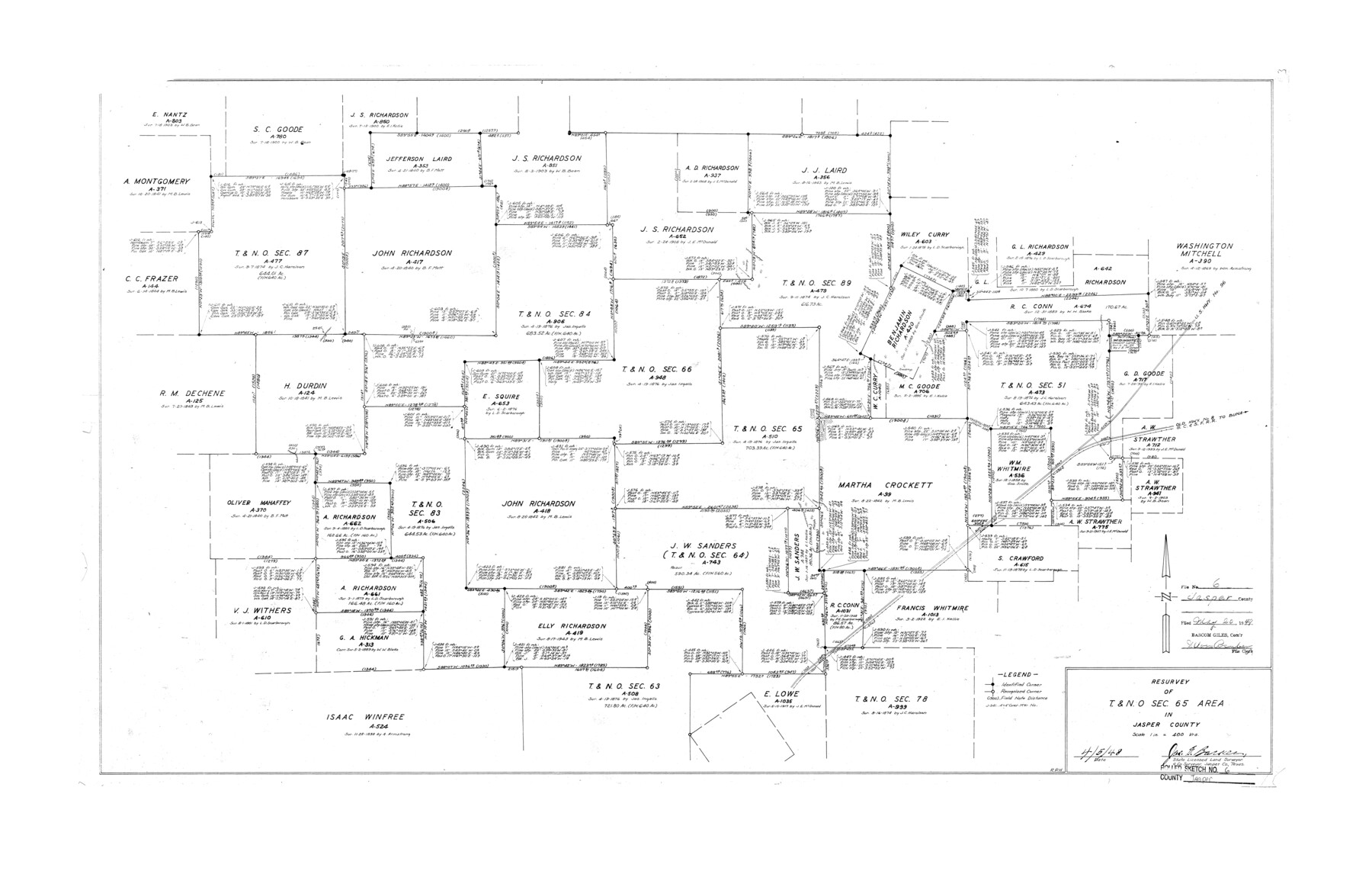
Jasper County Rolled Sketch 6
Resurvey of T. & N. O. sec. 65 area in Jasper County
-
Map/Doc
6353
-
Collection
General Map Collection
-
Object Dates
1948/4/5 (Creation Date)
1949/5/20 (File Date)
-
People and Organizations
Jas. G. Barker (Surveyor/Engineer)
-
Counties
Jasper
-
Subjects
Surveying Rolled Sketch
-
Height x Width
27.8 x 43.7 inches
70.6 x 111.0 cm
-
Scale
1" = 400 varas
Part of: General Map Collection
Map of Jasper and Newton Counties

Print $20.00
- Digital $50.00
Map of Jasper and Newton Counties
1862
Size 36.5 x 25.8 inches
Map/Doc 3714
Sabine Pass and Lake

Print $20.00
- Digital $50.00
Sabine Pass and Lake
1945
Size 46.5 x 27.3 inches
Map/Doc 69822
Wise County Working Sketch 19

Print $20.00
- Digital $50.00
Wise County Working Sketch 19
1978
Size 28.6 x 32.5 inches
Map/Doc 72633
Lamar County Working Sketch 5

Print $20.00
- Digital $50.00
Lamar County Working Sketch 5
1962
Size 21.5 x 23.6 inches
Map/Doc 70266
Hutchinson County Working Sketch 8

Print $20.00
- Digital $50.00
Hutchinson County Working Sketch 8
1919
Size 24.8 x 16.7 inches
Map/Doc 66366
Harris County Sketch File 81

Print $20.00
- Digital $50.00
Harris County Sketch File 81
Size 25.5 x 16.5 inches
Map/Doc 11669
Moore County Working Sketch 15

Print $20.00
- Digital $50.00
Moore County Working Sketch 15
1981
Size 20.8 x 35.3 inches
Map/Doc 71197
Nueces County Rolled Sketch 94

Print $108.00
Nueces County Rolled Sketch 94
1983
Size 24.2 x 36.6 inches
Map/Doc 7044
Flight Mission No. DQN-2K, Frame 157, Calhoun County

Print $20.00
- Digital $50.00
Flight Mission No. DQN-2K, Frame 157, Calhoun County
1953
Size 18.5 x 22.2 inches
Map/Doc 84319
Map Showing Location of Dallas & Greenville Railway through Hunt County, Texas

Print $2.00
- Digital $50.00
Map Showing Location of Dallas & Greenville Railway through Hunt County, Texas
Size 11.9 x 8.2 inches
Map/Doc 64486
Outer Continental Shelf Leasing Maps (Louisiana Offshore Operations)

Print $20.00
- Digital $50.00
Outer Continental Shelf Leasing Maps (Louisiana Offshore Operations)
1954
Size 12.6 x 14.4 inches
Map/Doc 76113
Randall County Boundary File 1

Print $26.00
- Digital $50.00
Randall County Boundary File 1
Size 14.0 x 8.5 inches
Map/Doc 58098
You may also like
Rusk County Working Sketch 22

Print $20.00
- Digital $50.00
Rusk County Working Sketch 22
1950
Size 22.5 x 12.8 inches
Map/Doc 63658
Gaines County Working Sketch 25

Print $20.00
- Digital $50.00
Gaines County Working Sketch 25
1983
Size 37.5 x 38.4 inches
Map/Doc 69325
Flight Mission No. CLL-4N, Frame 39, Willacy County

Print $20.00
- Digital $50.00
Flight Mission No. CLL-4N, Frame 39, Willacy County
1954
Size 18.3 x 22.0 inches
Map/Doc 87112
Trinity River, Terrell Sheet/Kings Creek

Print $20.00
- Digital $50.00
Trinity River, Terrell Sheet/Kings Creek
1930
Size 42.3 x 19.7 inches
Map/Doc 65229
Wise County Sketch File 45

Print $4.00
- Digital $50.00
Wise County Sketch File 45
Size 8.6 x 14.2 inches
Map/Doc 40605
Collin County Boundary File 1

Print $8.00
- Digital $50.00
Collin County Boundary File 1
Size 12.7 x 8.1 inches
Map/Doc 51678
[Val Verde County]
![63096, [Val Verde County], General Map Collection](https://historictexasmaps.com/wmedia_w700/maps/63096.tif.jpg)
Print $20.00
- Digital $50.00
[Val Verde County]
1898
Size 42.6 x 34.9 inches
Map/Doc 63096
Dallas County Sketch File 24

Print $4.00
- Digital $50.00
Dallas County Sketch File 24
1860
Size 14.9 x 8.4 inches
Map/Doc 20459
Erath County Sketch File 12

Print $4.00
- Digital $50.00
Erath County Sketch File 12
1871
Size 10.3 x 8.1 inches
Map/Doc 22281
Purchase Area Map, Ropesville Rural Communities, Hockley County, Texas

Print $40.00
- Digital $50.00
Purchase Area Map, Ropesville Rural Communities, Hockley County, Texas
1937
Size 52.9 x 29.3 inches
Map/Doc 89681
Irion County Working Sketch 9

Print $20.00
- Digital $50.00
Irion County Working Sketch 9
1941
Size 13.6 x 17.2 inches
Map/Doc 66418
Coryell County

Print $20.00
- Digital $50.00
Coryell County
1936
Size 44.5 x 41.2 inches
Map/Doc 73117