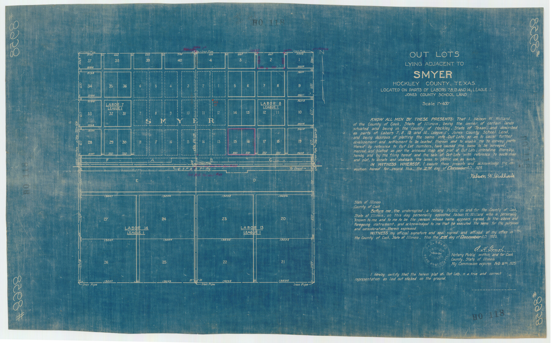
Outlots Lying Adjacent to Smyer Hockley County, Texas Located on Parts of Labors 7, 8, 13, and 14, League 1. Jones County School Land
HO118
-
Map/Doc
92224
-
Collection
Twichell Survey Records
-
Counties
Hockley
-
Height x Width
32.6 x 20.4 inches
82.8 x 51.8 cm
Part of: Twichell Survey Records
[Sketch showing San Augustine, Morris, Stephens and Eastland School Land Leagues and adjacent Blocks]
![89918, [Sketch showing San Augustine, Morris, Stephens and Eastland School Land Leagues and adjacent Blocks], Twichell Survey Records](https://historictexasmaps.com/wmedia_w700/maps/89918-1.tif.jpg)
Print $40.00
- Digital $50.00
[Sketch showing San Augustine, Morris, Stephens and Eastland School Land Leagues and adjacent Blocks]
Size 54.7 x 43.5 inches
Map/Doc 89918
[Blocks 1 and 2 along River in Motley County]
![91507, [Blocks 1 and 2 along River in Motley County], Twichell Survey Records](https://historictexasmaps.com/wmedia_w700/maps/91507-1.tif.jpg)
Print $20.00
- Digital $50.00
[Blocks 1 and 2 along River in Motley County]
1876
Size 21.3 x 16.6 inches
Map/Doc 91507
Part of P. S. L. Blks. B-15 & B-16 - W. D. Twichell Corners

Print $20.00
- Digital $50.00
Part of P. S. L. Blks. B-15 & B-16 - W. D. Twichell Corners
1938
Size 36.7 x 24.8 inches
Map/Doc 90844
Map [showing surveys 820-829] Along Red River
![89813, Map [showing surveys 820-829] Along Red River, Twichell Survey Records](https://historictexasmaps.com/wmedia_w700/maps/89813-1.tif.jpg)
Print $20.00
- Digital $50.00
Map [showing surveys 820-829] Along Red River
1920
Size 40.4 x 45.2 inches
Map/Doc 89813
Working Sketch Crockett County

Print $20.00
- Digital $50.00
Working Sketch Crockett County
1925
Size 16.6 x 15.2 inches
Map/Doc 90476
Plat Showing Survey for Harvest Queen Mills in Sec. 2 Blk. A & Sec. 4 Blk. O Lubbock County, Texas

Print $20.00
- Digital $50.00
Plat Showing Survey for Harvest Queen Mills in Sec. 2 Blk. A & Sec. 4 Blk. O Lubbock County, Texas
1956
Size 36.9 x 39.5 inches
Map/Doc 89893
[Mrs. May Vinson Survey]
![91943, [Mrs. May Vinson Survey], Twichell Survey Records](https://historictexasmaps.com/wmedia_w700/maps/91943-1.tif.jpg)
Print $20.00
- Digital $50.00
[Mrs. May Vinson Survey]
Size 25.0 x 14.6 inches
Map/Doc 91943
[Central Part of Hockley County]
![91192, [Central Part of Hockley County], Twichell Survey Records](https://historictexasmaps.com/wmedia_w700/maps/91192-1.tif.jpg)
Print $20.00
- Digital $50.00
[Central Part of Hockley County]
Size 34.6 x 21.0 inches
Map/Doc 91192
[T. & P. Block 35, Townships 4N and 5N]
![90574, [T. & P. Block 35, Townships 4N and 5N], Twichell Survey Records](https://historictexasmaps.com/wmedia_w700/maps/90574-1.tif.jpg)
Print $20.00
- Digital $50.00
[T. & P. Block 35, Townships 4N and 5N]
1907
Size 29.8 x 34.7 inches
Map/Doc 90574
[Blocks T2, T3, and K13]
![90997, [Blocks T2, T3, and K13], Twichell Survey Records](https://historictexasmaps.com/wmedia_w700/maps/90997-1.tif.jpg)
Print $20.00
- Digital $50.00
[Blocks T2, T3, and K13]
Size 20.7 x 19.9 inches
Map/Doc 90997
H. & T. C. Block 47, Sections 1-50; Block E, Sections 1-16; Block G, Sections 1-14

Print $20.00
- Digital $50.00
H. & T. C. Block 47, Sections 1-50; Block E, Sections 1-16; Block G, Sections 1-14
Size 21.5 x 10.3 inches
Map/Doc 91173

You may also like
General Highway Map, Upshur County, Texas

Print $20.00
General Highway Map, Upshur County, Texas
1961
Size 18.1 x 24.8 inches
Map/Doc 79692
Fisher County Working Sketch 3

Print $20.00
- Digital $50.00
Fisher County Working Sketch 3
1926
Size 19.7 x 15.7 inches
Map/Doc 69137
Flight Mission No. BRE-1P, Frame 4, Nueces County

Print $20.00
- Digital $50.00
Flight Mission No. BRE-1P, Frame 4, Nueces County
1956
Size 18.3 x 22.2 inches
Map/Doc 86612
Montague County Working Sketch 43

Print $20.00
- Digital $50.00
Montague County Working Sketch 43
2010
Size 23.3 x 27.2 inches
Map/Doc 89284
Flight Mission No. BRA-6M, Frame 153, Jefferson County

Print $20.00
- Digital $50.00
Flight Mission No. BRA-6M, Frame 153, Jefferson County
1953
Size 18.5 x 22.2 inches
Map/Doc 85454
Burleson County Working Sketch 44

Print $20.00
- Digital $50.00
Burleson County Working Sketch 44
1991
Size 22.4 x 25.0 inches
Map/Doc 67763
Coke County Working Sketch 21

Print $20.00
- Digital $50.00
Coke County Working Sketch 21
1949
Size 22.9 x 29.4 inches
Map/Doc 68058
Scurry County Rolled Sketch 5

Print $40.00
- Digital $50.00
Scurry County Rolled Sketch 5
Size 48.4 x 41.1 inches
Map/Doc 9913
Orange County Working Sketch 41

Print $20.00
- Digital $50.00
Orange County Working Sketch 41
1979
Size 28.0 x 18.2 inches
Map/Doc 71373
Grimes County Sketch File 4b

Print $10.00
- Digital $50.00
Grimes County Sketch File 4b
1873
Size 10.2 x 8.4 inches
Map/Doc 24637
Flight Mission No. DQN-1K, Frame 105, Calhoun County

Print $20.00
- Digital $50.00
Flight Mission No. DQN-1K, Frame 105, Calhoun County
1953
Size 18.4 x 22.2 inches
Map/Doc 84172
Walker County Working Sketch 1

Print $20.00
- Digital $50.00
Walker County Working Sketch 1
1912
Size 20.1 x 18.4 inches
Map/Doc 72281