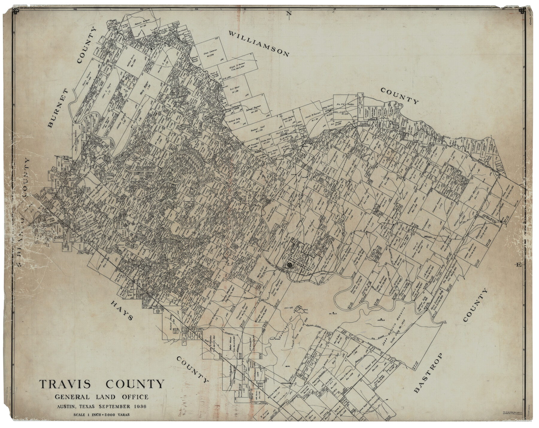
Travis County
-
Map/Doc
63078
-
Collection
General Map Collection
-
Object Dates
9/1936 (Creation Date)
-
People and Organizations
Texas General Land Office (Publisher)
J.O. Barrow (Draftsman)
J.O. Barrow (Compiler)
-
Counties
Travis
-
Subjects
County
-
Height x Width
43.2 x 54.6 inches
109.7 x 138.7 cm
-
Comments
Traced July 1, 1938 by J. L. Woodland.
Part of: General Map Collection
Shelby County Rolled Sketch 7

Print $40.00
- Digital $50.00
Shelby County Rolled Sketch 7
1945
Size 61.1 x 44.4 inches
Map/Doc 9922
Map of Nacogdoches County

Print $20.00
- Digital $50.00
Map of Nacogdoches County
1881
Size 24.0 x 21.3 inches
Map/Doc 4602
Official Map of the State of Texas to accompany the Statistical and Descriptive Work, "Resources, Soil and Climate of Texas"

Print $20.00
- Digital $50.00
Official Map of the State of Texas to accompany the Statistical and Descriptive Work, "Resources, Soil and Climate of Texas"
1882
Size 31.1 x 33.1 inches
Map/Doc 2134
Cottle County Working Sketch 4

Print $20.00
- Digital $50.00
Cottle County Working Sketch 4
1916
Size 34.3 x 31.4 inches
Map/Doc 68314
Sutton County Sketch File 48

Print $4.00
- Digital $50.00
Sutton County Sketch File 48
1939
Size 11.3 x 8.7 inches
Map/Doc 37521
Flight Mission No. DIX-7P, Frame 16, Aransas County

Print $20.00
- Digital $50.00
Flight Mission No. DIX-7P, Frame 16, Aransas County
1956
Size 18.9 x 22.5 inches
Map/Doc 83868
Dickens County Boundary File 2

Print $52.00
- Digital $50.00
Dickens County Boundary File 2
Size 8.9 x 4.2 inches
Map/Doc 52533
Hays County Boundary File 1

Print $14.00
- Digital $50.00
Hays County Boundary File 1
Size 9.5 x 5.2 inches
Map/Doc 54586
Goliad County Working Sketch 16

Print $20.00
- Digital $50.00
Goliad County Working Sketch 16
1949
Size 30.0 x 46.9 inches
Map/Doc 63206
Denton County Sketch File 3

Print $4.00
- Digital $50.00
Denton County Sketch File 3
1855
Size 12.5 x 8.2 inches
Map/Doc 20688
Bee County Working Sketch 20

Print $20.00
- Digital $50.00
Bee County Working Sketch 20
1982
Size 23.6 x 21.3 inches
Map/Doc 67270
Moore County Sketch File 2

Print $36.00
- Digital $50.00
Moore County Sketch File 2
Size 14.2 x 8.6 inches
Map/Doc 31929
You may also like
Eastland County Working Sketch 3

Print $20.00
- Digital $50.00
Eastland County Working Sketch 3
1917
Size 16.5 x 20.2 inches
Map/Doc 68784
In the Supreme Court of the United States The State of Oklahoma, Complainant vs. The State of Texas, Defendant, The United States of America, Intervener - 1921

Print $40.00
- Digital $50.00
In the Supreme Court of the United States The State of Oklahoma, Complainant vs. The State of Texas, Defendant, The United States of America, Intervener - 1921
1921
Size 25.7 x 61.1 inches
Map/Doc 75127
San Augustine County Sketch File 21

Print $4.00
- Digital $50.00
San Augustine County Sketch File 21
1873
Size 12.8 x 7.9 inches
Map/Doc 35685
Port Facilities at Houston, Tex.

Print $20.00
- Digital $50.00
Port Facilities at Houston, Tex.
1924
Size 14.1 x 30.3 inches
Map/Doc 97167
McMullen County Working Sketch 39

Print $40.00
- Digital $50.00
McMullen County Working Sketch 39
1975
Size 53.3 x 31.7 inches
Map/Doc 70740
[T. H. Jones Blk. O, Blk. F, Coyote Lake Area, Sutton County School Land Leagues]
![90246, [T. H. Jones Blk. O, Blk. F, Coyote Lake Area, Sutton County School Land Leagues], Twichell Survey Records](https://historictexasmaps.com/wmedia_w700/maps/90246-1.tif.jpg)
Print $20.00
- Digital $50.00
[T. H. Jones Blk. O, Blk. F, Coyote Lake Area, Sutton County School Land Leagues]
Size 21.0 x 33.6 inches
Map/Doc 90246
[Subdivision of Lgs. 109-112, Crosby County School Land]
![90154, [Subdivision of Lgs. 109-112, Crosby County School Land], Twichell Survey Records](https://historictexasmaps.com/wmedia_w700/maps/90154-1.tif.jpg)
Print $20.00
- Digital $50.00
[Subdivision of Lgs. 109-112, Crosby County School Land]
Size 11.8 x 21.3 inches
Map/Doc 90154
Edwards County Working Sketch 134

Print $40.00
- Digital $50.00
Edwards County Working Sketch 134
1986
Size 29.4 x 54.2 inches
Map/Doc 69010
[Surveys along Tehuacano and Grindstone Creek, drawings X and Y]
![299, [Surveys along Tehuacano and Grindstone Creek, drawings X and Y], General Map Collection](https://historictexasmaps.com/wmedia_w700/maps/299.tif.jpg)
Print $20.00
- Digital $50.00
[Surveys along Tehuacano and Grindstone Creek, drawings X and Y]
1846
Size 12.4 x 18.3 inches
Map/Doc 299
Galveston to Rio Grande

Print $20.00
- Digital $50.00
Galveston to Rio Grande
1973
Size 44.2 x 36.8 inches
Map/Doc 69956
San Jacinto County Working Sketch 42b

Print $3.00
- Digital $50.00
San Jacinto County Working Sketch 42b
1979
Size 10.7 x 14.4 inches
Map/Doc 63756
Presidio County Sketch File 74

Print $8.00
- Digital $50.00
Presidio County Sketch File 74
1946
Size 11.4 x 8.8 inches
Map/Doc 34687