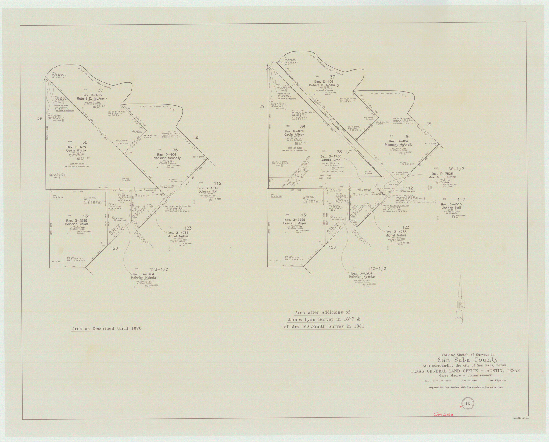
San Saba County Working Sketch 12
-
Map/Doc
63800
-
Collection
General Map Collection
-
Object Dates
5/20/1993 (Creation Date)
-
People and Organizations
Joan Kilpatrick (Draftsman)
-
Counties
San Saba
-
Subjects
Surveying Working Sketch
-
Height x Width
32.2 x 39.9 inches
81.8 x 101.4 cm
-
Scale
1" = 400 varas
Part of: General Map Collection
McMullen County Sketch File 19

Print $4.00
- Digital $50.00
McMullen County Sketch File 19
Size 12.8 x 8.1 inches
Map/Doc 31371
Presidio County Rolled Sketch 81

Print $20.00
- Digital $50.00
Presidio County Rolled Sketch 81
Size 19.2 x 36.8 inches
Map/Doc 7368
Brewster County Working Sketch 118

Print $20.00
- Digital $50.00
Brewster County Working Sketch 118
1929
Size 27.0 x 20.5 inches
Map/Doc 67718
Pecos County Rolled Sketch 25

Print $48.00
- Digital $50.00
Pecos County Rolled Sketch 25
1887
Size 18.8 x 41.1 inches
Map/Doc 7209
El Paso County Working Sketch 25

Print $20.00
- Digital $50.00
El Paso County Working Sketch 25
1962
Size 42.7 x 41.9 inches
Map/Doc 69047
Castro County Sketch File 5a

Print $8.00
- Digital $50.00
Castro County Sketch File 5a
1904
Size 11.2 x 8.7 inches
Map/Doc 17491
Greer County Sketch File 8

Print $20.00
- Digital $50.00
Greer County Sketch File 8
Size 16.7 x 23.6 inches
Map/Doc 11584
Flight Mission No. BRA-8M, Frame 71, Jefferson County

Print $20.00
- Digital $50.00
Flight Mission No. BRA-8M, Frame 71, Jefferson County
1953
Size 18.7 x 22.3 inches
Map/Doc 85591
Brewster County Working Sketch 119

Print $20.00
- Digital $50.00
Brewster County Working Sketch 119
1909
Size 29.3 x 29.0 inches
Map/Doc 67719
Flight Mission No. CGI-1N, Frame 184, Cameron County

Print $20.00
- Digital $50.00
Flight Mission No. CGI-1N, Frame 184, Cameron County
1955
Size 18.5 x 22.2 inches
Map/Doc 84519
Wilson County

Print $20.00
- Digital $50.00
Wilson County
1921
Size 38.9 x 46.2 inches
Map/Doc 77461
Terrell County Sketch File 31

Print $20.00
- Digital $50.00
Terrell County Sketch File 31
1940
Size 27.0 x 25.1 inches
Map/Doc 12426
You may also like
Fort Bend County Working Sketch 5

Print $20.00
- Digital $50.00
Fort Bend County Working Sketch 5
1915
Size 14.5 x 20.9 inches
Map/Doc 69211
Map of Montague County

Print $20.00
- Digital $50.00
Map of Montague County
1868
Size 24.1 x 19.7 inches
Map/Doc 3887
Wheeler County

Print $20.00
- Digital $50.00
Wheeler County
1899
Size 44.2 x 38.7 inches
Map/Doc 63121
Nueces County Sketch File 80

Print $102.00
- Digital $50.00
Nueces County Sketch File 80
1997
Size 11.0 x 8.5 inches
Map/Doc 33104
Coryell County Working Sketch 18

Print $20.00
- Digital $50.00
Coryell County Working Sketch 18
1965
Size 24.6 x 34.3 inches
Map/Doc 68225
Shelby County Working Sketch 36

Print $20.00
- Digital $50.00
Shelby County Working Sketch 36
2011
Size 35.0 x 36.0 inches
Map/Doc 90093
Cuadro Historico-Geroglifico de la Peregrinacion de las Tribus Aztecas que Poblaron el Valle de Mexico (Num. 2)

Print $20.00
- Digital $50.00
Cuadro Historico-Geroglifico de la Peregrinacion de las Tribus Aztecas que Poblaron el Valle de Mexico (Num. 2)
Size 22.9 x 31.3 inches
Map/Doc 97012
Somervell County Sketch File 7

Print $8.00
- Digital $50.00
Somervell County Sketch File 7
1987
Size 11.4 x 8.9 inches
Map/Doc 36850
General Highway Map. Detail of Cities and Towns in Collin County, Texas

Print $20.00
General Highway Map. Detail of Cities and Towns in Collin County, Texas
1961
Size 18.2 x 24.8 inches
Map/Doc 79414
Flight Mission No. BQY-4M, Frame 119, Harris County

Print $20.00
- Digital $50.00
Flight Mission No. BQY-4M, Frame 119, Harris County
1953
Size 18.7 x 22.4 inches
Map/Doc 85287

Loving County

Print $20.00
- Digital $50.00
Loving County
1889
Size 24.6 x 19.6 inches
Map/Doc 91385