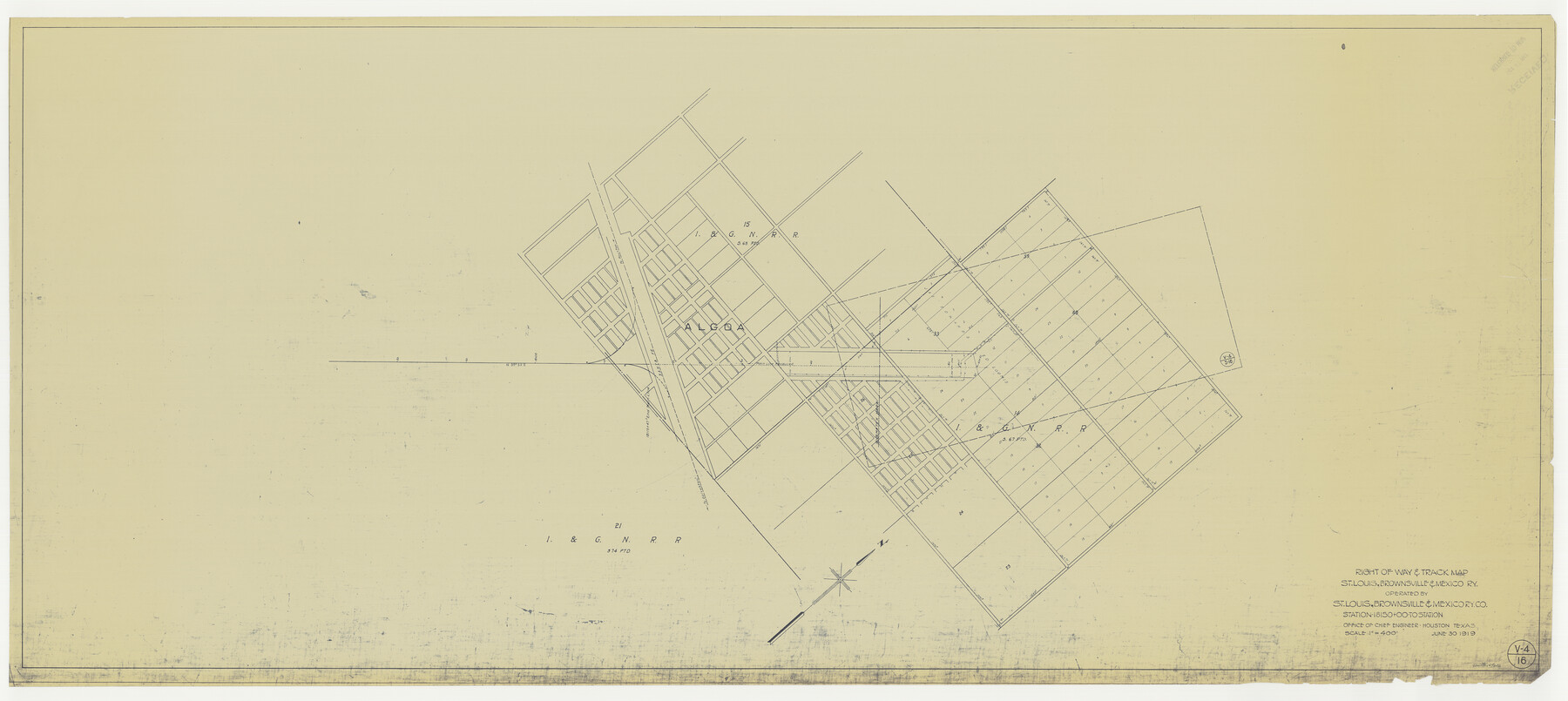
Right of Way & Track Map, St. Louis, Brownsville & Mexico Ry. operated by St. Louis, Brownsville & Mexico Ry. Co.
Station 18150+00 to Station
Z-2-183
-
Map/Doc
64626
-
Collection
General Map Collection
-
Object Dates
1919/6/30 (Creation Date)
-
Counties
Brazoria
-
Subjects
Railroads
-
Height x Width
25.5 x 57.0 inches
64.8 x 144.8 cm
-
Medium
blueprint/diazo
-
Scale
1" = 400 feet
-
Comments
Jefferson Lake Oil Company.
See counter nos. 64612 through 64625 for other sheets. -
Features
SLB&M
[Railroad line] to Houston
AT&SF
[Railroad line] to Galveston
Algoa
Part of: General Map Collection
Maps of Gulf Intracoastal Waterway, Texas - Sabine River to the Rio Grande and connecting waterways including ship channels

Print $20.00
- Digital $50.00
Maps of Gulf Intracoastal Waterway, Texas - Sabine River to the Rio Grande and connecting waterways including ship channels
1966
Size 14.6 x 22.3 inches
Map/Doc 61965
[Missouri, Kansas & Texas] E. L. & R. R. Railroad, Morris Co.
![64273, [Missouri, Kansas & Texas] E. L. & R. R. Railroad, Morris Co., General Map Collection](https://historictexasmaps.com/wmedia_w700/maps/64273.tif.jpg)
Print $20.00
- Digital $50.00
[Missouri, Kansas & Texas] E. L. & R. R. Railroad, Morris Co.
1906
Size 13.1 x 28.4 inches
Map/Doc 64273
Nueces County Rolled Sketch 38

Print $458.00
- Digital $50.00
Nueces County Rolled Sketch 38
Size 10.1 x 16.4 inches
Map/Doc 47717

Terrell County Working Sketch 75

Print $20.00
- Digital $50.00
Terrell County Working Sketch 75
1982
Size 41.4 x 43.7 inches
Map/Doc 69596
Flight Mission No. DCL-7C, Frame 45, Kenedy County

Print $20.00
- Digital $50.00
Flight Mission No. DCL-7C, Frame 45, Kenedy County
1943
Size 15.4 x 15.3 inches
Map/Doc 86033
Real County Working Sketch 85

Print $20.00
- Digital $50.00
Real County Working Sketch 85
1988
Size 27.0 x 30.0 inches
Map/Doc 71977
Guadalupe County Sketch File 15e

Print $6.00
- Digital $50.00
Guadalupe County Sketch File 15e
Size 9.9 x 8.1 inches
Map/Doc 24707
Val Verde County Sketch File Z8

Print $20.00
- Digital $50.00
Val Verde County Sketch File Z8
1884
Size 25.2 x 19.9 inches
Map/Doc 12553
Sabine Pass and Lake

Print $20.00
- Digital $50.00
Sabine Pass and Lake
1971
Size 47.0 x 27.5 inches
Map/Doc 69825
Flight Mission No. DCL-6C, Frame 18, Kenedy County

Print $20.00
- Digital $50.00
Flight Mission No. DCL-6C, Frame 18, Kenedy County
1943
Size 18.6 x 22.5 inches
Map/Doc 85875
Brazoria County State Real Property Sketch 1

Print $20.00
- Digital $50.00
Brazoria County State Real Property Sketch 1
1997
Size 24.4 x 34.8 inches
Map/Doc 80127
You may also like
Gregg County Rolled Sketch 16A

Print $20.00
- Digital $50.00
Gregg County Rolled Sketch 16A
1942
Size 30.1 x 40.4 inches
Map/Doc 6039
Sectional Map of Texas traversed by the Southern Pacific Lines and connections

Print $20.00
- Digital $50.00
Sectional Map of Texas traversed by the Southern Pacific Lines and connections
1916
Size 20.6 x 22.3 inches
Map/Doc 95800
Flight Mission No. DCL-7C, Frame 44, Kenedy County

Print $20.00
- Digital $50.00
Flight Mission No. DCL-7C, Frame 44, Kenedy County
1943
Size 15.4 x 15.2 inches
Map/Doc 86032
Navigation Maps of Gulf Intracoastal Waterway, Port Arthur to Brownsville, Texas

Print $4.00
- Digital $50.00
Navigation Maps of Gulf Intracoastal Waterway, Port Arthur to Brownsville, Texas
1951
Size 16.7 x 21.4 inches
Map/Doc 65433
Gaines County Rolled Sketch 35

Print $20.00
- Digital $50.00
Gaines County Rolled Sketch 35
2014
Size 18.7 x 25.9 inches
Map/Doc 93695
Hudspeth County Working Sketch 31

Print $40.00
- Digital $50.00
Hudspeth County Working Sketch 31
1972
Size 56.2 x 41.2 inches
Map/Doc 66314
Culberson County Working Sketch 26

Print $20.00
- Digital $50.00
Culberson County Working Sketch 26
1951
Size 42.7 x 28.3 inches
Map/Doc 68479
Gillespie County Working Sketch 4

Print $20.00
- Digital $50.00
Gillespie County Working Sketch 4
1969
Size 32.5 x 35.3 inches
Map/Doc 63167

Wise County Working Sketch 25

Print $40.00
- Digital $50.00
Wise County Working Sketch 25
1983
Size 37.1 x 53.8 inches
Map/Doc 72639
Reeves County Working Sketch 4a

Print $20.00
- Digital $50.00
Reeves County Working Sketch 4a
1933
Size 26.0 x 34.6 inches
Map/Doc 63447
Township 12 South Range 13 West, South Western District, Louisiana

Print $20.00
- Digital $50.00
Township 12 South Range 13 West, South Western District, Louisiana
1838
Size 19.5 x 24.7 inches
Map/Doc 65855