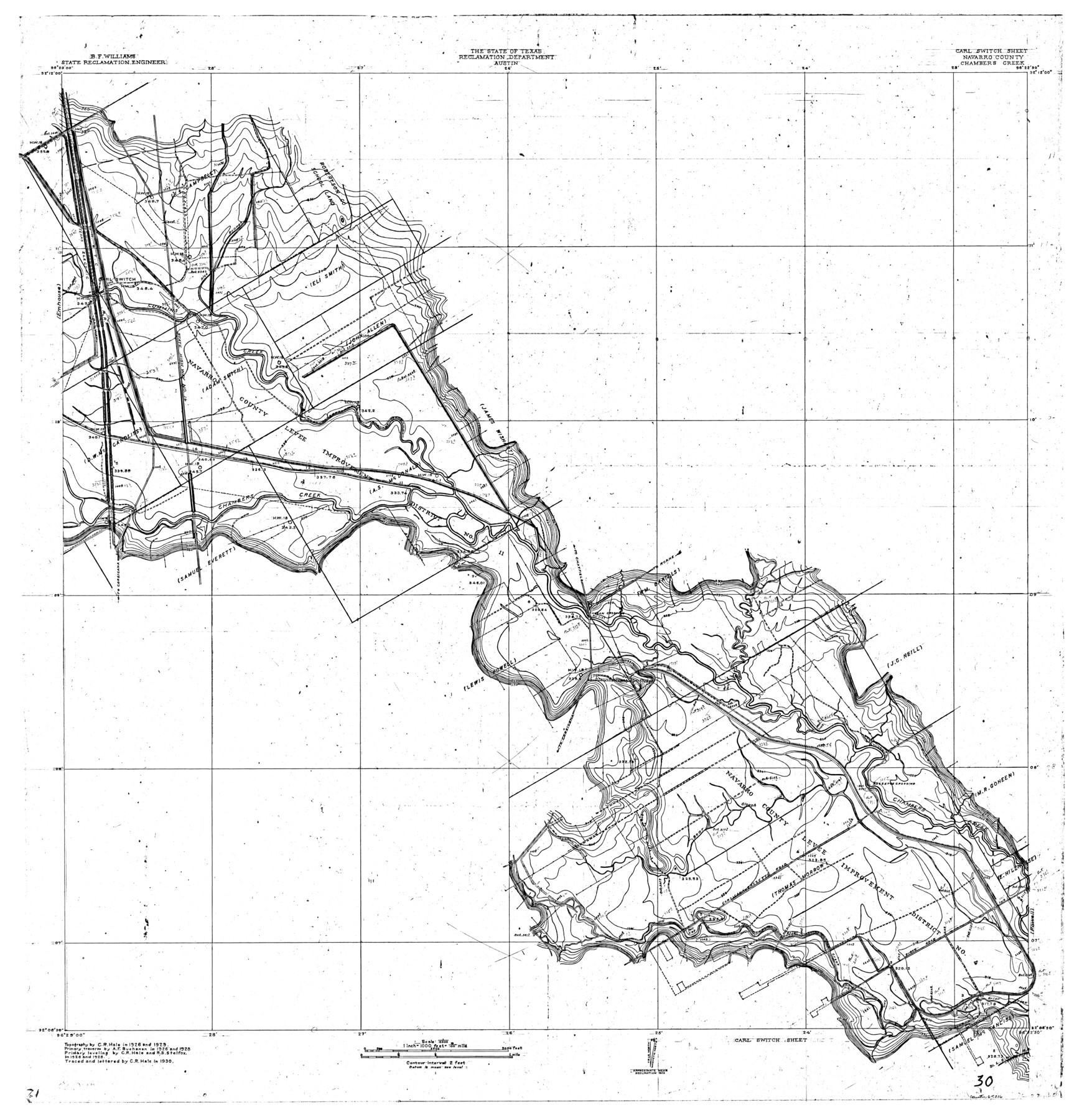
Trinity River, Carl Switch Sheet/Chambers Creek
-
Map/Doc
65216
-
Collection
General Map Collection
-
Object Dates
1930 (Creation Date)
-
People and Organizations
Texas State Reclamation Department (Publisher)
Curtis R. Hale (Compiler)
Curtis R. Hale (Draftsman)
Curtis R. Hale (Surveyor/Engineer)
R.S. Stelfox (Surveyor/Engineer)
A.F. Buchanan (Surveyor/Engineer)
-
Counties
Navarro
-
Subjects
River Surveys Topographic
-
Height x Width
39.2 x 37.8 inches
99.6 x 96.0 cm
-
Comments
Carl Switch Sheet located east of the Emhouse Sheet.
Part of: General Map Collection
Map of Freestone County

Print $20.00
- Digital $50.00
Map of Freestone County
1858
Size 22.3 x 24.1 inches
Map/Doc 3564
Ellis County Sketch File 11

Print $40.00
- Digital $50.00
Ellis County Sketch File 11
1860
Size 12.6 x 16.2 inches
Map/Doc 21847
Garza County Working Sketch 9

Print $20.00
- Digital $50.00
Garza County Working Sketch 9
1952
Size 15.7 x 18.0 inches
Map/Doc 63156
Kimble County Sketch File 18

Print $22.00
- Digital $50.00
Kimble County Sketch File 18
1890
Size 8.8 x 14.2 inches
Map/Doc 28953
Brewster County Working Sketch 92

Print $40.00
- Digital $50.00
Brewster County Working Sketch 92
1975
Size 61.9 x 39.4 inches
Map/Doc 67692
Flight Mission No. CLL-4N, Frame 39, Willacy County

Print $20.00
- Digital $50.00
Flight Mission No. CLL-4N, Frame 39, Willacy County
1954
Size 18.3 x 22.0 inches
Map/Doc 87112
Harris County Sketch File 13a

Print $4.00
- Digital $50.00
Harris County Sketch File 13a
1860
Size 10.8 x 6.0 inches
Map/Doc 25357
Reeves County Working Sketch 51

Print $20.00
- Digital $50.00
Reeves County Working Sketch 51
1974
Size 45.4 x 34.6 inches
Map/Doc 63494
Red River County Working Sketch 26

Print $20.00
- Digital $50.00
Red River County Working Sketch 26
1961
Size 30.9 x 31.6 inches
Map/Doc 72009
A New Map of Texas

Print $20.00
- Digital $50.00
A New Map of Texas
1841
Size 18.2 x 17.2 inches
Map/Doc 96636
Brazoria County Sketch File 25

Print $8.00
- Digital $50.00
Brazoria County Sketch File 25
1875
Size 8.4 x 13.2 inches
Map/Doc 15024
El Paso County Sketch File 29

Print $14.00
- Digital $50.00
El Paso County Sketch File 29
1949
Size 14.5 x 9.4 inches
Map/Doc 22076
You may also like
[Sketch showing H. & G. N. Block A on the north side of the Canadian River and H. & T. C. Block 46 on the south side of the Canadian River]
![91763, [Sketch showing H. & G. N. Block A on the north side of the Canadian River and H. & T. C. Block 46 on the south side of the Canadian River], Twichell Survey Records](https://historictexasmaps.com/wmedia_w700/maps/91763-1.tif.jpg)
Print $20.00
- Digital $50.00
[Sketch showing H. & G. N. Block A on the north side of the Canadian River and H. & T. C. Block 46 on the south side of the Canadian River]
1927
Size 25.1 x 11.2 inches
Map/Doc 91763
Foard County Sketch File 21

Print $14.00
- Digital $50.00
Foard County Sketch File 21
Size 13.1 x 8.6 inches
Map/Doc 22839
Bravo Ranch situated in Hartley and Oldham Counties, Texas

Print $40.00
- Digital $50.00
Bravo Ranch situated in Hartley and Oldham Counties, Texas
Size 38.8 x 51.3 inches
Map/Doc 89930
Real County Rolled Sketch JCA

Print $20.00
- Digital $50.00
Real County Rolled Sketch JCA
Size 27.9 x 36.5 inches
Map/Doc 7470
Flight Mission No. BRA-16M, Frame 88, Jefferson County

Print $20.00
- Digital $50.00
Flight Mission No. BRA-16M, Frame 88, Jefferson County
1953
Size 18.5 x 22.3 inches
Map/Doc 85700
Dawson County Working Sketch 12

Print $20.00
- Digital $50.00
Dawson County Working Sketch 12
1951
Size 24.6 x 27.7 inches
Map/Doc 68556
Hutchinson County Working Sketch 49

Print $20.00
- Digital $50.00
Hutchinson County Working Sketch 49
1988
Size 35.2 x 37.3 inches
Map/Doc 66409
Flight Mission No. CGI-3N, Frame 49, Cameron County

Print $20.00
- Digital $50.00
Flight Mission No. CGI-3N, Frame 49, Cameron County
1954
Size 18.8 x 22.4 inches
Map/Doc 84555
Childress County

Print $20.00
- Digital $50.00
Childress County
1892
Size 36.2 x 27.1 inches
Map/Doc 3392
Polk County Working Sketch 10

Print $40.00
- Digital $50.00
Polk County Working Sketch 10
1937
Size 42.7 x 48.4 inches
Map/Doc 71625
Bexar County Sketch File 46

Print $40.00
- Digital $50.00
Bexar County Sketch File 46
1888
Size 24.7 x 22.6 inches
Map/Doc 10924
Childress County Rolled Sketch 19

Print $20.00
- Digital $50.00
Childress County Rolled Sketch 19
2004
Size 24.6 x 18.6 inches
Map/Doc 81937