La Salle County Rolled Sketch 4
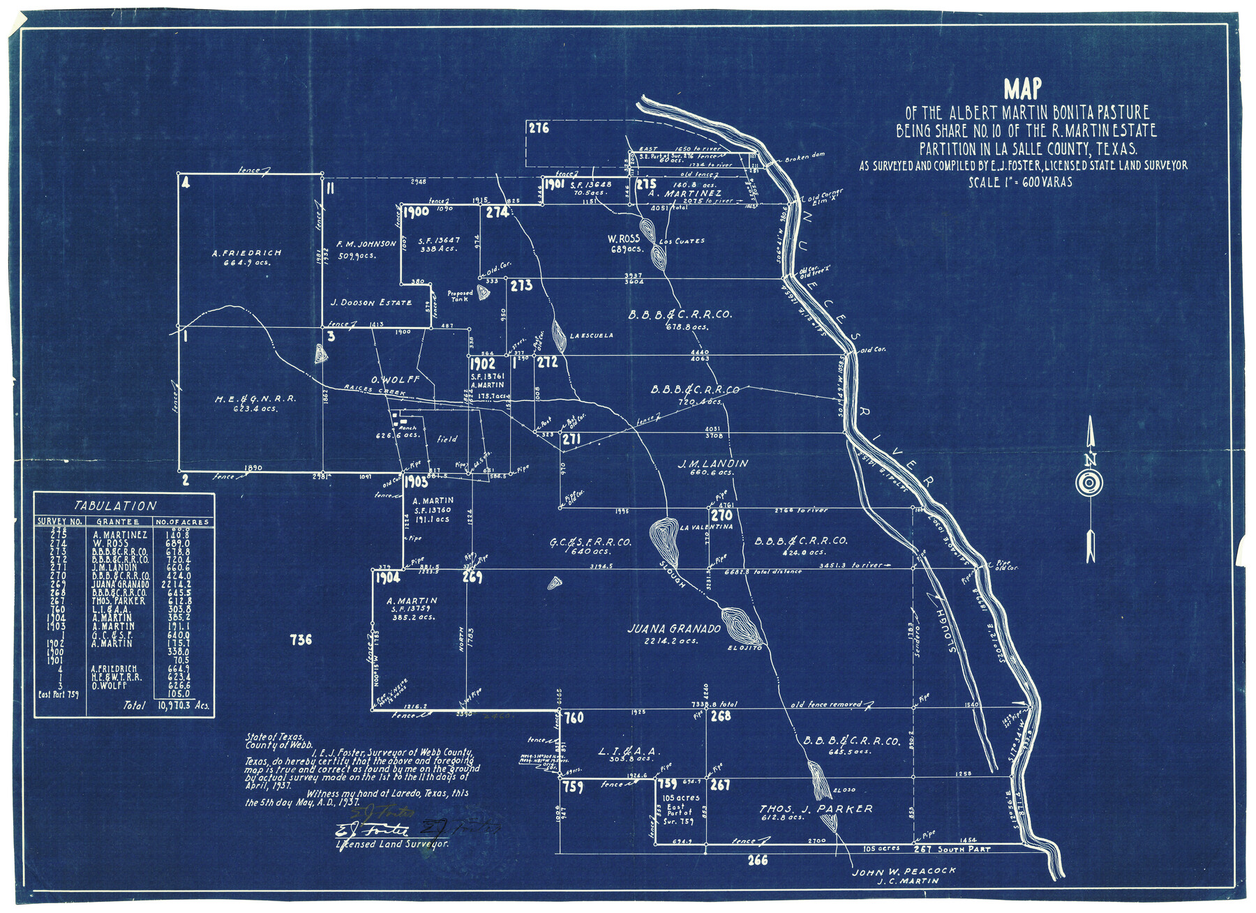
Map of the Albert Martin Bonita Pasture being share no. 10 of the R. Martin Estate partition in La Salle County, Texas
-
Map/Doc
6569
-
Collection
General Map Collection
-
Object Dates
5/5/1937 (Creation Date)
6/26/1937 (File Date)
4/11/1937 (Survey Date)
-
People and Organizations
E.J. Foster (Surveyor/Engineer)
-
Counties
La Salle
-
Subjects
Surveying Rolled Sketch
-
Height x Width
20.9 x 27.5 inches
53.1 x 69.9 cm
-
Medium
blueprint/diazo
-
Scale
1" = 600 varas
Part of: General Map Collection
Flight Mission No. CRE-1R, Frame 67, Jackson County

Print $20.00
- Digital $50.00
Flight Mission No. CRE-1R, Frame 67, Jackson County
1956
Size 18.7 x 22.3 inches
Map/Doc 85330
Reeves County Rolled Sketch 24

Print $20.00
- Digital $50.00
Reeves County Rolled Sketch 24
1982
Size 37.2 x 24.9 inches
Map/Doc 7493
Terrell County Sketch File 20

Print $6.00
- Digital $50.00
Terrell County Sketch File 20
1910
Size 10.9 x 12.6 inches
Map/Doc 37946
Cochran County Boundary File 3a

Print $34.00
- Digital $50.00
Cochran County Boundary File 3a
Size 11.2 x 8.8 inches
Map/Doc 51538
Clay County Sketch File 46

Print $20.00
- Digital $50.00
Clay County Sketch File 46
1890
Size 18.9 x 19.3 inches
Map/Doc 11098
Brewster County Working Sketch 9

Print $20.00
- Digital $50.00
Brewster County Working Sketch 9
1910
Size 14.3 x 14.4 inches
Map/Doc 67542
Houston County Working Sketch 10

Print $20.00
- Digital $50.00
Houston County Working Sketch 10
1953
Size 32.7 x 27.3 inches
Map/Doc 66240
Stephens County Working Sketch 23

Print $20.00
- Digital $50.00
Stephens County Working Sketch 23
1975
Size 31.0 x 38.8 inches
Map/Doc 63966
Lamar County Working Sketch 9

Print $20.00
- Digital $50.00
Lamar County Working Sketch 9
1975
Size 42.1 x 27.9 inches
Map/Doc 70270
Throckmorton County

Print $20.00
- Digital $50.00
Throckmorton County
1943
Size 46.7 x 37.4 inches
Map/Doc 95653
Presidio County Rolled Sketch 100

Print $20.00
- Digital $50.00
Presidio County Rolled Sketch 100
1954
Size 30.4 x 30.2 inches
Map/Doc 7382
Foard County Sketch File 36

Print $20.00
- Digital $50.00
Foard County Sketch File 36
Size 15.4 x 28.0 inches
Map/Doc 11498
You may also like
Map of Webb Co.

Print $20.00
- Digital $50.00
Map of Webb Co.
1901
Size 40.4 x 47.1 inches
Map/Doc 16919
Bravo Deed, Instrument 24, Tract A and Tract B

Print $20.00
- Digital $50.00
Bravo Deed, Instrument 24, Tract A and Tract B
Size 33.4 x 14.3 inches
Map/Doc 91434
Freestone County Rolled Sketch 7

Print $20.00
- Digital $50.00
Freestone County Rolled Sketch 7
1918
Size 41.4 x 36.9 inches
Map/Doc 8895
General Highway Map, Leon County, Texas

Print $20.00
General Highway Map, Leon County, Texas
1940
Size 18.3 x 24.9 inches
Map/Doc 79172
Trinity River, Onion Creek Station Sheet/Chambers Creek

Print $6.00
- Digital $50.00
Trinity River, Onion Creek Station Sheet/Chambers Creek
1931
Size 35.1 x 32.4 inches
Map/Doc 65234
Trinity County Sketch File 24

Print $4.00
- Digital $50.00
Trinity County Sketch File 24
Size 7.5 x 10.5 inches
Map/Doc 38556
Knox County Working Sketch 2

Print $20.00
- Digital $50.00
Knox County Working Sketch 2
1913
Size 22.7 x 14.2 inches
Map/Doc 70244
[H. & G. N. RR. Co. Block 1]
![90888, [H. & G. N. RR. Co. Block 1], Twichell Survey Records](https://historictexasmaps.com/wmedia_w700/maps/90888-1.tif.jpg)
Print $20.00
- Digital $50.00
[H. & G. N. RR. Co. Block 1]
Size 37.1 x 43.6 inches
Map/Doc 90888
Shelby County

Print $20.00
- Digital $50.00
Shelby County
1945
Size 39.1 x 44.2 inches
Map/Doc 77421
Colorado County Sketch File 2

Print $4.00
- Digital $50.00
Colorado County Sketch File 2
Size 11.1 x 8.4 inches
Map/Doc 18911
Map of Jackson County

Print $20.00
- Digital $50.00
Map of Jackson County
1840
Size 34.9 x 25.3 inches
Map/Doc 3707
Flight Mission No. BQR-5K, Frame 73, Brazoria County

Print $20.00
- Digital $50.00
Flight Mission No. BQR-5K, Frame 73, Brazoria County
1952
Size 19.1 x 22.6 inches
Map/Doc 84018