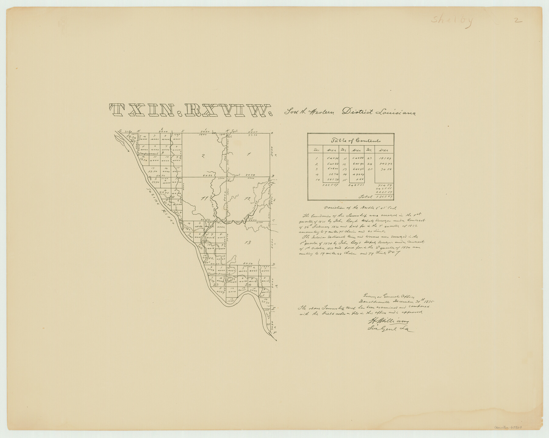
Township 11 North Range 16 West, South Western District, Louisiana
Louisiana Land Surveys Across From Shelby County, Texas 2
-
Map/Doc
65869
-
Collection
General Map Collection
-
Object Dates
1834 (Creation Date)
-
People and Organizations
Surveyor General's Office Louisiana (Publisher)
John Boyd (Surveyor/Engineer)
-
Subjects
Texas Boundaries
-
Height x Width
19.7 x 24.7 inches
50.0 x 62.7 cm
Part of: General Map Collection
Henderson County Rolled Sketch 6

Print $20.00
- Digital $50.00
Henderson County Rolled Sketch 6
1962
Size 23.4 x 34.8 inches
Map/Doc 6202
[Right of Way & Track Map, The Texas & Pacific Ry. Co. Main Line]
![64680, [Right of Way & Track Map, The Texas & Pacific Ry. Co. Main Line], General Map Collection](https://historictexasmaps.com/wmedia_w700/maps/64680.tif.jpg)
Print $20.00
- Digital $50.00
[Right of Way & Track Map, The Texas & Pacific Ry. Co. Main Line]
Size 11.0 x 19.0 inches
Map/Doc 64680
Andrews County Rolled Sketch 46

Print $40.00
- Digital $50.00
Andrews County Rolled Sketch 46
2013
Size 52.0 x 36.0 inches
Map/Doc 93641
Calcasieu Pass to Sabine Pass

Print $20.00
- Digital $50.00
Calcasieu Pass to Sabine Pass
1925
Size 44.1 x 36.0 inches
Map/Doc 69804
Lipscomb County Boundary File 2

Print $6.00
- Digital $50.00
Lipscomb County Boundary File 2
Size 11.1 x 8.6 inches
Map/Doc 56315
Deaf Smith County Sketch File E

Print $20.00
- Digital $50.00
Deaf Smith County Sketch File E
Size 22.3 x 12.9 inches
Map/Doc 11308
Flight Mission No. DQN-1K, Frame 31, Calhoun County

Print $20.00
- Digital $50.00
Flight Mission No. DQN-1K, Frame 31, Calhoun County
1953
Size 15.4 x 15.5 inches
Map/Doc 84136
Van Zandt County Sketch File 25

Print $4.00
- Digital $50.00
Van Zandt County Sketch File 25
Size 7.6 x 8.8 inches
Map/Doc 39443
Edwards County Working Sketch 22

Print $20.00
- Digital $50.00
Edwards County Working Sketch 22
1938
Size 15.3 x 18.5 inches
Map/Doc 68898
Flight Mission No. DQN-1K, Frame 77, Calhoun County

Print $20.00
- Digital $50.00
Flight Mission No. DQN-1K, Frame 77, Calhoun County
1953
Size 18.5 x 22.2 inches
Map/Doc 84162
Fort Bend County Sketch File 16 1/2

Print $16.00
- Digital $50.00
Fort Bend County Sketch File 16 1/2
Size 14.3 x 8.8 inches
Map/Doc 22927
Flight Mission No. BRE-1P, Frame 32, Nueces County

Print $20.00
- Digital $50.00
Flight Mission No. BRE-1P, Frame 32, Nueces County
1956
Size 18.4 x 22.6 inches
Map/Doc 86628
You may also like
Working Sketch in Dickens and Kent Counties

Print $20.00
- Digital $50.00
Working Sketch in Dickens and Kent Counties
1904
Size 24.2 x 30.5 inches
Map/Doc 91035
[Parts of T. & P. 30 and 31, T3N, H. & T. C. 27]
![91206, [Parts of T. & P. 30 and 31, T3N, H. & T. C. 27], Twichell Survey Records](https://historictexasmaps.com/wmedia_w700/maps/91206-1.tif.jpg)
Print $20.00
- Digital $50.00
[Parts of T. & P. 30 and 31, T3N, H. & T. C. 27]
Size 17.4 x 14.4 inches
Map/Doc 91206
Due Southwest over the Cotton Belt Route

Due Southwest over the Cotton Belt Route
1891
Map/Doc 96773
Campaign map of Texas, Louisiana and Arkansas, showing all the battle fields and also the marches of Walker's Division. [1861-65]
![93567, Campaign map of Texas, Louisiana and Arkansas, showing all the battle fields and also the marches of Walker's Division. [1861-65], Library of Congress](https://historictexasmaps.com/wmedia_w700/maps/93567.tif.jpg)
Print $20.00
Campaign map of Texas, Louisiana and Arkansas, showing all the battle fields and also the marches of Walker's Division. [1861-65]
1871
Size 27.6 x 37.0 inches
Map/Doc 93567
A Map of Sterling County

Print $20.00
- Digital $50.00
A Map of Sterling County
1919
Size 33.3 x 21.6 inches
Map/Doc 4054
La Salle County Working Sketch 3

Print $20.00
- Digital $50.00
La Salle County Working Sketch 3
1914
Size 15.0 x 14.2 inches
Map/Doc 70304
Presidio County Working Sketch 91

Print $40.00
- Digital $50.00
Presidio County Working Sketch 91
1974
Size 42.0 x 59.4 inches
Map/Doc 71768
[Blocks C31, C32, C36-C39]
![91867, [Blocks C31, C32, C36-C39], Twichell Survey Records](https://historictexasmaps.com/wmedia_w700/maps/91867-1.tif.jpg)
Print $20.00
- Digital $50.00
[Blocks C31, C32, C36-C39]
Size 15.6 x 16.0 inches
Map/Doc 91867
[Cotton Belt, St. Louis Southwestern Railway of Texas, Alignment through Smith County]
![64376, [Cotton Belt, St. Louis Southwestern Railway of Texas, Alignment through Smith County], General Map Collection](https://historictexasmaps.com/wmedia_w700/maps/64376-1.tif.jpg)
Print $20.00
- Digital $50.00
[Cotton Belt, St. Louis Southwestern Railway of Texas, Alignment through Smith County]
1903
Size 22.0 x 29.3 inches
Map/Doc 64376
Ft. W. & R. G. Ry. Right of Way Map, Chapin to Bluffdale, Hood County, Texas

Print $40.00
- Digital $50.00
Ft. W. & R. G. Ry. Right of Way Map, Chapin to Bluffdale, Hood County, Texas
1918
Size 37.3 x 120.2 inches
Map/Doc 64642
Atascosa County Sketch File 1

Print $8.00
- Digital $50.00
Atascosa County Sketch File 1
Size 8.1 x 6.1 inches
Map/Doc 13718
Webb County Sketch File 63

Print $20.00
- Digital $50.00
Webb County Sketch File 63
1947
Size 17.2 x 21.2 inches
Map/Doc 12653