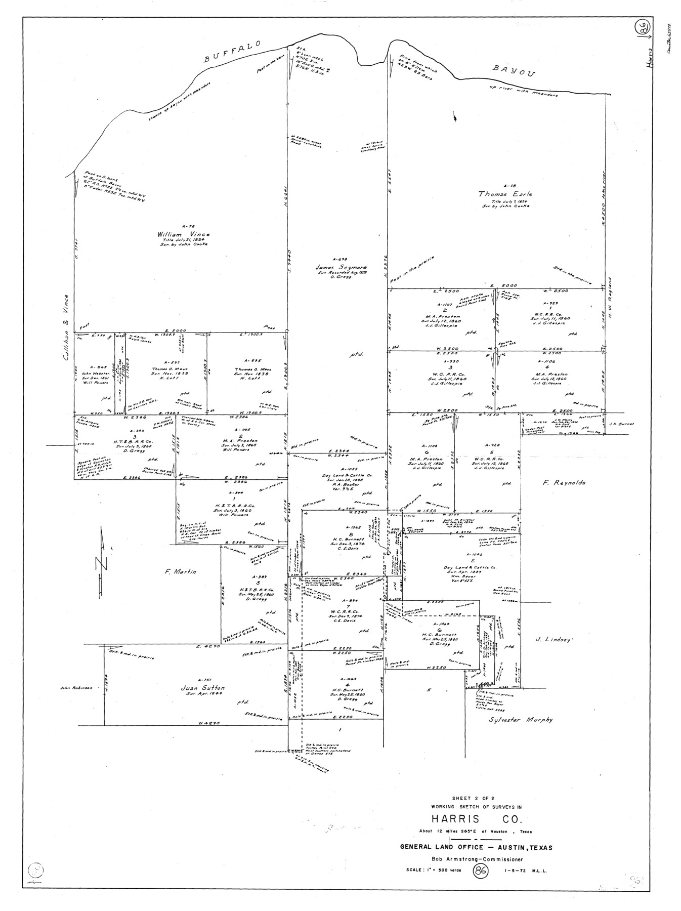
Harris County Working Sketch 86
-
Map/Doc
65978
-
Collection
General Map Collection
-
Object Dates
1/5/1972 (Creation Date)
-
People and Organizations
M. L. Liles (Draftsman)
-
Counties
Harris
-
Subjects
Surveying Working Sketch
-
Height x Width
42.7 x 31.9 inches
108.5 x 81.0 cm
-
Scale
1" = 500 varas
Part of: General Map Collection
Coryell County Sketch File 17

Print $4.00
- Digital $50.00
Coryell County Sketch File 17
1854
Size 6.7 x 8.4 inches
Map/Doc 19375
Fisher County Working Sketch 20

Print $20.00
- Digital $50.00
Fisher County Working Sketch 20
1993
Size 38.1 x 26.6 inches
Map/Doc 69154
Zapata County Sketch File 19

Print $20.00
- Digital $50.00
Zapata County Sketch File 19
1957
Size 23.5 x 13.2 inches
Map/Doc 12724
Flight Mission No. CRC-3R, Frame 8, Chambers County

Print $20.00
- Digital $50.00
Flight Mission No. CRC-3R, Frame 8, Chambers County
1956
Size 18.6 x 22.2 inches
Map/Doc 84782
Mason County Boundary File 5

Print $20.00
- Digital $50.00
Mason County Boundary File 5
Size 9.7 x 7.0 inches
Map/Doc 56862
Nueces County Sketch File 1

Print $24.00
- Digital $50.00
Nueces County Sketch File 1
1847
Size 7.6 x 12.5 inches
Map/Doc 32497
Chambers County Sketch File 7

Print $4.00
- Digital $50.00
Chambers County Sketch File 7
1867
Size 10.2 x 8.4 inches
Map/Doc 17542
Current Miscellaneous File 34

Print $10.00
- Digital $50.00
Current Miscellaneous File 34
1953
Size 14.1 x 8.7 inches
Map/Doc 73942
Presidio County Working Sketch 49

Print $20.00
- Digital $50.00
Presidio County Working Sketch 49
1951
Size 34.5 x 47.0 inches
Map/Doc 71726
Briscoe County Sketch File N

Print $40.00
- Digital $50.00
Briscoe County Sketch File N
Size 26.0 x 21.9 inches
Map/Doc 11012
Flight Mission No. DQN-1K, Frame 103, Calhoun County

Print $20.00
- Digital $50.00
Flight Mission No. DQN-1K, Frame 103, Calhoun County
1953
Size 18.5 x 22.1 inches
Map/Doc 84170
Andrews County Rolled Sketch 8

Print $40.00
- Digital $50.00
Andrews County Rolled Sketch 8
1928
Size 31.4 x 54.0 inches
Map/Doc 8388
You may also like
[H. & G. N. RR. Company, Block B3]
![90718, [H. & G. N. RR. Company, Block B3], Twichell Survey Records](https://historictexasmaps.com/wmedia_w700/maps/90718-1.tif.jpg)
Print $20.00
- Digital $50.00
[H. & G. N. RR. Company, Block B3]
Size 34.9 x 28.8 inches
Map/Doc 90718
Burleson County Working Sketch 34

Print $20.00
- Digital $50.00
Burleson County Working Sketch 34
1981
Size 20.0 x 12.2 inches
Map/Doc 67753
Edwards County Sketch File ECS

Print $6.00
- Digital $50.00
Edwards County Sketch File ECS
1937
Size 11.5 x 8.8 inches
Map/Doc 21774
Current Miscellaneous File 68

Print $22.00
- Digital $50.00
Current Miscellaneous File 68
Size 11.2 x 8.8 inches
Map/Doc 74134
Fort Bend County Working Sketch 14

Print $20.00
- Digital $50.00
Fort Bend County Working Sketch 14
1948
Size 37.4 x 32.7 inches
Map/Doc 69220
Hunt County Rolled Sketch 5

Print $20.00
- Digital $50.00
Hunt County Rolled Sketch 5
1956
Size 22.9 x 23.0 inches
Map/Doc 6271
The Republic County of Fayette. May 3, 1838

Print $20.00
The Republic County of Fayette. May 3, 1838
2020
Size 14.7 x 21.7 inches
Map/Doc 96132
Randall County Sketch File 2

Print $4.00
- Digital $50.00
Randall County Sketch File 2
1913
Size 7.3 x 8.8 inches
Map/Doc 34961
Louisiana and Texas Intracoastal Waterway

Print $20.00
- Digital $50.00
Louisiana and Texas Intracoastal Waterway
1929
Size 13.9 x 19.3 inches
Map/Doc 83343
[Sketch showing H. & T. C. Block 47]
![91699, [Sketch showing H. & T. C. Block 47], Twichell Survey Records](https://historictexasmaps.com/wmedia_w700/maps/91699-1.tif.jpg)
Print $2.00
- Digital $50.00
[Sketch showing H. & T. C. Block 47]
Size 6.1 x 6.7 inches
Map/Doc 91699
Hutchinson County

Print $20.00
- Digital $50.00
Hutchinson County
1922
Size 40.7 x 34.8 inches
Map/Doc 77321
General Highway Map, Wise County, Texas

Print $20.00
General Highway Map, Wise County, Texas
1940
Size 18.2 x 24.8 inches
Map/Doc 79284