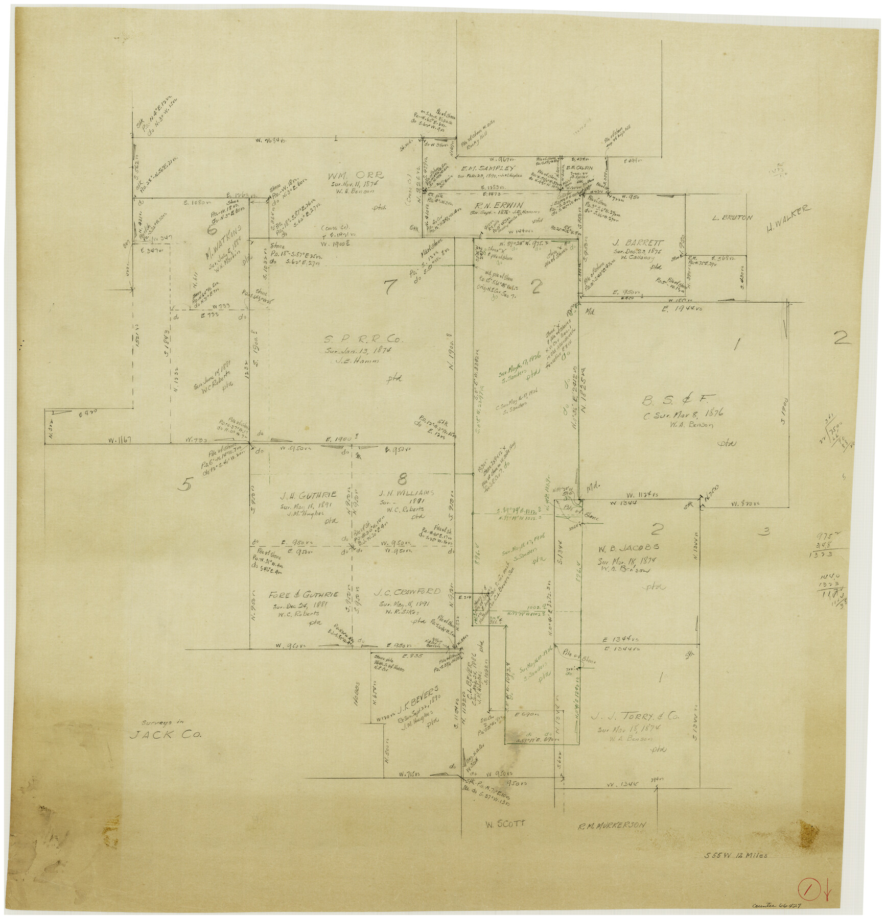
Jack County Working Sketch 1
-
Map/Doc
66427
-
Collection
General Map Collection
-
Counties
Jack
-
Subjects
Surveying Working Sketch
-
Height x Width
28.4 x 27.1 inches
72.1 x 68.8 cm
Part of: General Map Collection
Jefferson County Sketch File X

Print $42.00
- Digital $50.00
Jefferson County Sketch File X
Size 17.1 x 13.3 inches
Map/Doc 28087
Burleson County Working Sketch 34

Print $20.00
- Digital $50.00
Burleson County Working Sketch 34
1981
Size 20.0 x 12.2 inches
Map/Doc 67753
Crockett County Working Sketch 89

Print $20.00
- Digital $50.00
Crockett County Working Sketch 89
1978
Size 36.4 x 44.5 inches
Map/Doc 68422
Colorado County Sketch File 7

Print $4.00
- Digital $50.00
Colorado County Sketch File 7
1862
Size 13.1 x 8.0 inches
Map/Doc 18925
Mitchell County Rolled Sketch 2A

Print $20.00
- Digital $50.00
Mitchell County Rolled Sketch 2A
Size 24.2 x 18.5 inches
Map/Doc 88857
A Map of Part of Panola County [Judicial District]
![328, A Map of Part of Panola County [Judicial District], General Map Collection](https://historictexasmaps.com/wmedia_w700/maps/328.tif.jpg)
Print $20.00
- Digital $50.00
A Map of Part of Panola County [Judicial District]
1841
Size 18.3 x 15.4 inches
Map/Doc 328
Dickens County Sketch File 29

Print $6.00
- Digital $50.00
Dickens County Sketch File 29
1921
Size 5.9 x 8.8 inches
Map/Doc 21016
Matagorda County Working Sketch 1

Print $20.00
- Digital $50.00
Matagorda County Working Sketch 1
Size 24.1 x 17.1 inches
Map/Doc 70859
Tom Green County Working Sketch 5

Print $20.00
- Digital $50.00
Tom Green County Working Sketch 5
1948
Size 34.0 x 40.3 inches
Map/Doc 69374

El Paso County Working Sketch Graphic Index - south part

Print $20.00
- Digital $50.00
El Paso County Working Sketch Graphic Index - south part
1977
Size 33.4 x 44.9 inches
Map/Doc 76537
Flight Mission No. BRE-1P, Frame 71, Nueces County

Print $20.00
- Digital $50.00
Flight Mission No. BRE-1P, Frame 71, Nueces County
1956
Size 18.6 x 22.2 inches
Map/Doc 86653
You may also like
Starr County Sketch File 8

Print $7.00
- Digital $50.00
Starr County Sketch File 8
Size 10.1 x 12.4 inches
Map/Doc 36858
La Salle County Working Sketch 14

Print $20.00
- Digital $50.00
La Salle County Working Sketch 14
1941
Size 37.8 x 36.7 inches
Map/Doc 70315

Flight Mission No. DQN-1K, Frame 117, Calhoun County

Print $20.00
- Digital $50.00
Flight Mission No. DQN-1K, Frame 117, Calhoun County
1953
Size 18.5 x 22.2 inches
Map/Doc 84183
Mapa original de Texas por el Ciudadano Estevan F. Austin Presentado al Excmo. Sr. Presidente, por su Autor

Mapa original de Texas por el Ciudadano Estevan F. Austin Presentado al Excmo. Sr. Presidente, por su Autor
1830
Size 31.6 x 25.4 inches
Map/Doc 94562
Flight Mission No. BRA-16M, Frame 150, Jefferson County

Print $20.00
- Digital $50.00
Flight Mission No. BRA-16M, Frame 150, Jefferson County
1953
Size 18.5 x 22.3 inches
Map/Doc 85756
Montague County Rolled Sketch 9

Print $20.00
- Digital $50.00
Montague County Rolled Sketch 9
Size 29.1 x 39.4 inches
Map/Doc 6793
Randall County Rolled Sketch 9A

Print $20.00
- Digital $50.00
Randall County Rolled Sketch 9A
1985
Size 44.5 x 35.0 inches
Map/Doc 10314
Zapata County Working Sketch 21

Print $40.00
- Digital $50.00
Zapata County Working Sketch 21
1981
Size 32.8 x 52.5 inches
Map/Doc 62072
[T. & P. Block 35, Townships 1N - 5N]
![93138, [T. & P. Block 35, Townships 1N - 5N], Twichell Survey Records](https://historictexasmaps.com/wmedia_w700/maps/93138-1.tif.jpg)
Print $40.00
- Digital $50.00
[T. & P. Block 35, Townships 1N - 5N]
Size 23.8 x 87.2 inches
Map/Doc 93138
General Highway Map, Hill County, Texas

Print $20.00
General Highway Map, Hill County, Texas
1961
Size 24.5 x 18.2 inches
Map/Doc 79520
Culberson County Working Sketch 66

Print $40.00
- Digital $50.00
Culberson County Working Sketch 66
1975
Size 52.1 x 33.2 inches
Map/Doc 68520