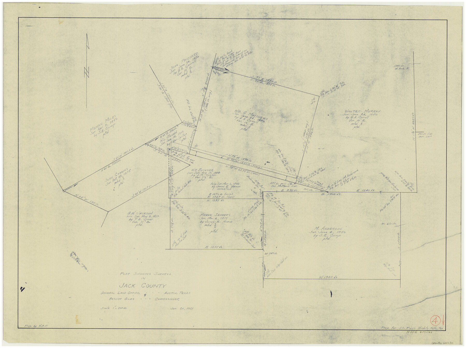
Jack County Working Sketch 4
-
Map/Doc
66430
-
Collection
General Map Collection
-
Object Dates
1/26/1951 (Creation Date)
-
Counties
Jack
-
Subjects
Surveying Working Sketch
-
Height x Width
24.0 x 32.2 inches
61.0 x 81.8 cm
-
Scale
1" = 200 varas
Part of: General Map Collection
Flight Mission No. DIX-10P, Frame 147, Aransas County

Print $20.00
- Digital $50.00
Flight Mission No. DIX-10P, Frame 147, Aransas County
1956
Size 18.7 x 22.4 inches
Map/Doc 83949
Wilbarger County Working Sketch 18

Print $20.00
- Digital $50.00
Wilbarger County Working Sketch 18
1965
Size 42.0 x 46.6 inches
Map/Doc 72556
Grayson County Sketch File 19

Print $7.00
- Digital $50.00
Grayson County Sketch File 19
1860
Size 12.1 x 7.7 inches
Map/Doc 24490
Sutton County Working Sketch 13

Print $40.00
- Digital $50.00
Sutton County Working Sketch 13
1972
Size 58.8 x 37.0 inches
Map/Doc 62356
Bee County Boundary File 5

Print $12.00
- Digital $50.00
Bee County Boundary File 5
Size 9.1 x 9.0 inches
Map/Doc 50452
Flight Mission No. BRE-1P, Frame 75, Nueces County

Print $20.00
- Digital $50.00
Flight Mission No. BRE-1P, Frame 75, Nueces County
1956
Size 18.4 x 22.2 inches
Map/Doc 86657
Dimmit County Working Sketch 18

Print $20.00
- Digital $50.00
Dimmit County Working Sketch 18
1946
Size 33.5 x 35.0 inches
Map/Doc 68679
Brown County Sketch File 21

Print $40.00
- Digital $50.00
Brown County Sketch File 21
Size 16.4 x 12.8 inches
Map/Doc 11021
Bowie County Working Sketch 6

Print $20.00
- Digital $50.00
Bowie County Working Sketch 6
1928
Size 27.4 x 22.9 inches
Map/Doc 67410
Eastland County Working Sketch Graphic Index

Print $20.00
- Digital $50.00
Eastland County Working Sketch Graphic Index
1945
Size 41.6 x 42.4 inches
Map/Doc 76529
Amistad International Reservoir on Rio Grande 87

Print $20.00
- Digital $50.00
Amistad International Reservoir on Rio Grande 87
1949
Size 28.4 x 40.1 inches
Map/Doc 75516
Kimble County Working Sketch 70

Print $20.00
- Digital $50.00
Kimble County Working Sketch 70
1965
Size 41.2 x 25.3 inches
Map/Doc 70138
You may also like
Dickens County Sketch File G

Print $8.00
- Digital $50.00
Dickens County Sketch File G
Size 12.0 x 8.7 inches
Map/Doc 20854
Coleman County Sketch File 3a

Print $20.00
- Digital $50.00
Coleman County Sketch File 3a
1857
Size 12.6 x 19.2 inches
Map/Doc 11117
Coke County Rolled Sketch 4

Print $20.00
- Digital $50.00
Coke County Rolled Sketch 4
Size 44.6 x 37.0 inches
Map/Doc 8624
Picturesque Glen Ridge, A Beautiful Suburb of Austin

Print $20.00
- Digital $50.00
Picturesque Glen Ridge, A Beautiful Suburb of Austin
1890
Size 28.9 x 40.9 inches
Map/Doc 584
Howard County Sketch File 10

Print $20.00
- Digital $50.00
Howard County Sketch File 10
Size 22.5 x 22.0 inches
Map/Doc 11798
Hall County Boundary File 1

Print $26.00
- Digital $50.00
Hall County Boundary File 1
Size 8.8 x 4.0 inches
Map/Doc 54158
Calhoun County Rolled Sketch 27

Print $127.00
- Digital $50.00
Calhoun County Rolled Sketch 27
1976
Size 10.1 x 16.0 inches
Map/Doc 43621
Travis County State Real Property Sketch 15

Print $20.00
- Digital $50.00
Travis County State Real Property Sketch 15
1995
Size 29.6 x 29.5 inches
Map/Doc 61674
Gillespie County

Print $20.00
- Digital $50.00
Gillespie County
1945
Size 36.7 x 45.6 inches
Map/Doc 77289
Hardeman County Working Sketch 11

Print $40.00
- Digital $50.00
Hardeman County Working Sketch 11
1960
Size 40.0 x 58.1 inches
Map/Doc 63392
[R. M. Thompson Block T2 and John H. Stephens Block S2 Conflict]
![91056, [R. M. Thompson Block T2 and John H. Stephens Block S2 Conflict], Twichell Survey Records](https://historictexasmaps.com/wmedia_w700/maps/91056-1.tif.jpg)
Print $20.00
- Digital $50.00
[R. M. Thompson Block T2 and John H. Stephens Block S2 Conflict]
Size 20.9 x 30.6 inches
Map/Doc 91056
