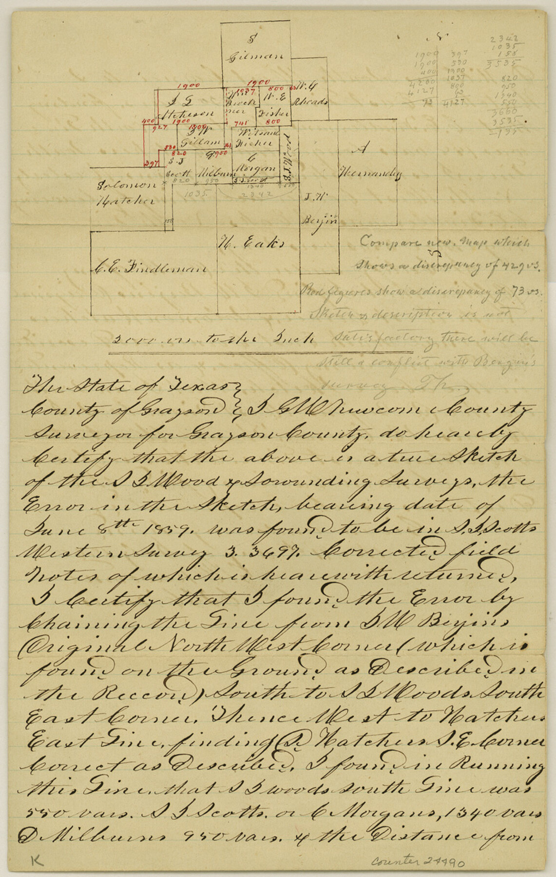
Grayson County Sketch File 19
[Sketch of surveys southwest of Sherman]
-
Map/Doc
24490
-
Collection
General Map Collection
-
Object Dates
1860/7/11 (Creation Date)
1860/7/19 (File Date)
-
People and Organizations
G.W. Newcome (Surveyor/Engineer)
-
Counties
Grayson
-
Subjects
Surveying Sketch File
-
Height x Width
12.1 x 7.7 inches
30.7 x 19.6 cm
-
Medium
paper, manuscript
-
Scale
1:2000
Part of: General Map Collection
Sketch E No. 3 Shewing the progress of the Survey at North & South Edisto Rivers and St. Helena Sound, South Carolina

Print $20.00
- Digital $50.00
Sketch E No. 3 Shewing the progress of the Survey at North & South Edisto Rivers and St. Helena Sound, South Carolina
1852
Size 10.9 x 19.5 inches
Map/Doc 97215

Presidio County Rolled Sketch 59

Print $20.00
- Digital $50.00
Presidio County Rolled Sketch 59
Size 27.6 x 18.2 inches
Map/Doc 7352
Jasper County Sketch File 1a

Print $8.00
- Digital $50.00
Jasper County Sketch File 1a
1859
Size 12.1 x 7.7 inches
Map/Doc 27765
Schleicher County Sketch File 37

Print $20.00
- Digital $50.00
Schleicher County Sketch File 37
1952
Size 24.9 x 29.3 inches
Map/Doc 12310
Atascosa County Sketch File 14

Print $40.00
- Digital $50.00
Atascosa County Sketch File 14
1870
Size 12.5 x 15.0 inches
Map/Doc 13773
Nueces County NRC Article 33.136 Location Key Sheet

Print $20.00
- Digital $50.00
Nueces County NRC Article 33.136 Location Key Sheet
1975
Size 27.3 x 23.0 inches
Map/Doc 88587
Randall County

Print $20.00
- Digital $50.00
Randall County
1958
Size 46.2 x 39.9 inches
Map/Doc 95620
Sketch of surveys on Deer Creek, Milam District

Print $2.00
- Digital $50.00
Sketch of surveys on Deer Creek, Milam District
1846
Size 7.8 x 10.9 inches
Map/Doc 76046
Castro County Rolled Sketch 7

Print $20.00
- Digital $50.00
Castro County Rolled Sketch 7
1908
Size 28.9 x 24.1 inches
Map/Doc 5417
Flight Mission No. CRC-3R, Frame 202, Chambers County

Print $20.00
- Digital $50.00
Flight Mission No. CRC-3R, Frame 202, Chambers County
1956
Size 18.7 x 22.4 inches
Map/Doc 84857

You may also like
Bandera County Sketch File 3

Print $6.00
- Digital $50.00
Bandera County Sketch File 3
1848
Size 11.6 x 10.3 inches
Map/Doc 13999
Mitchell County Boundary File 1

Print $38.00
- Digital $50.00
Mitchell County Boundary File 1
Size 9.1 x 8.4 inches
Map/Doc 57334
Carta Geografica General de la Republica Mexicana

Print $40.00
- Digital $50.00
Carta Geografica General de la Republica Mexicana
1845
Size 38.1 x 52.9 inches
Map/Doc 96438
Fort Bend Co.

Print $20.00
- Digital $50.00
Fort Bend Co.
1931
Size 39.1 x 40.8 inches
Map/Doc 73150
Hardeman County

Print $20.00
- Digital $50.00
Hardeman County
1935
Size 44.4 x 41.4 inches
Map/Doc 73170
Colorado County Working Sketch 15

Print $40.00
- Digital $50.00
Colorado County Working Sketch 15
1949
Size 31.4 x 63.3 inches
Map/Doc 68115
[Surveys near Onion Creek]
![108, [Surveys near Onion Creek], General Map Collection](https://historictexasmaps.com/wmedia_w700/maps/108-1.tif.jpg)
Print $2.00
- Digital $50.00
[Surveys near Onion Creek]
1841
Size 11.0 x 7.8 inches
Map/Doc 108
Kenedy County Rolled Sketch 14

Print $21.00
- Digital $50.00
Kenedy County Rolled Sketch 14
1951
Size 10.2 x 15.3 inches
Map/Doc 46433
Duval County Working Sketch 33

Print $20.00
- Digital $50.00
Duval County Working Sketch 33
1951
Size 21.9 x 23.3 inches
Map/Doc 68757
Wharton County Sketch File 10a

Print $20.00
- Digital $50.00
Wharton County Sketch File 10a
Size 11.0 x 19.0 inches
Map/Doc 12660
Stonewall County Working Sketch 29

Print $40.00
- Digital $50.00
Stonewall County Working Sketch 29
1979
Size 48.5 x 43.0 inches
Map/Doc 62336
Town of Beaumont in Jefferson County, Texas

Print $20.00
Town of Beaumont in Jefferson County, Texas
1850
Size 17.6 x 24.3 inches
Map/Doc 76267