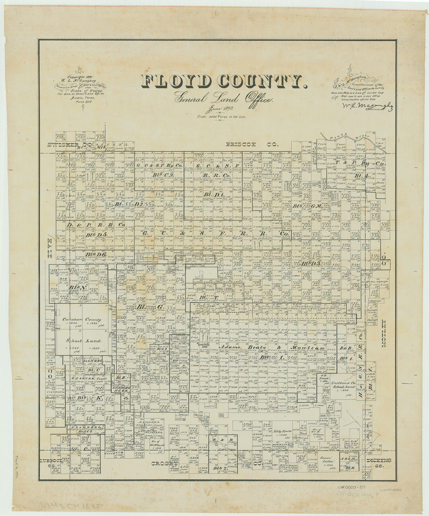
Floyd County
-
Map/Doc
66823
-
Collection
General Map Collection
-
Object Dates
1892 (Creation Date)
-
People and Organizations
Texas General Land Office (Publisher)
W.L. McGaughey (GLO Commissioner)
-
Counties
Floyd
-
Subjects
County
-
Height x Width
25.0 x 20.8 inches
63.5 x 52.8 cm
-
Comments
Copyrighted 1891.
Part of: General Map Collection
Bosque County Working Sketch 4

Print $20.00
- Digital $50.00
Bosque County Working Sketch 4
1901
Size 14.2 x 18.6 inches
Map/Doc 67437

Bexar County Working Sketch 3

Print $20.00
- Digital $50.00
Bexar County Working Sketch 3
1941
Size 19.6 x 21.6 inches
Map/Doc 67319
[Drawings of individual counties for Pressler and Langermann's 1879 Map of Texas]
![2140, [Drawings of individual counties for Pressler and Langermann's 1879 Map of Texas], General Map Collection](https://historictexasmaps.com/wmedia_w700/maps/2140-1.tif.jpg)
Print $20.00
- Digital $50.00
[Drawings of individual counties for Pressler and Langermann's 1879 Map of Texas]
1878
Size 28.5 x 42.0 inches
Map/Doc 2140
Medina County Boundary File 2

Print $11.00
- Digital $50.00
Medina County Boundary File 2
Size 13.0 x 8.1 inches
Map/Doc 57026
Flight Mission No. CRC-5R, Frame 19, Chambers County

Print $20.00
- Digital $50.00
Flight Mission No. CRC-5R, Frame 19, Chambers County
1956
Size 18.8 x 22.4 inches
Map/Doc 84941
General Land Office and State Reclamation Department - An Index Map

Print $20.00
- Digital $50.00
General Land Office and State Reclamation Department - An Index Map
1930
Size 26.2 x 16.6 inches
Map/Doc 65069
Dimmit County Sketch File 23

Print $38.00
- Digital $50.00
Dimmit County Sketch File 23
1894
Size 10.0 x 11.8 inches
Map/Doc 21133
Lampasas County Boundary File 3a

Print $8.00
- Digital $50.00
Lampasas County Boundary File 3a
Size 13.2 x 8.2 inches
Map/Doc 56106
[Maps of surveys in Reeves & Culberson Cos]
![61138, [Maps of surveys in Reeves & Culberson Cos], General Map Collection](https://historictexasmaps.com/wmedia_w700/maps/61138.tif.jpg)
Print $20.00
- Digital $50.00
[Maps of surveys in Reeves & Culberson Cos]
1937
Size 30.6 x 25.0 inches
Map/Doc 61138
El Paso County Boundary File 1

Print $48.00
- Digital $50.00
El Paso County Boundary File 1
Size 12.3 x 35.0 inches
Map/Doc 53015
Zapata County Rolled Sketch 28

Print $20.00
- Digital $50.00
Zapata County Rolled Sketch 28
Size 35.5 x 35.3 inches
Map/Doc 10174
You may also like
Menard County Rolled Sketch 18

Print $20.00
- Digital $50.00
Menard County Rolled Sketch 18
2024
Size 35.9 x 47.7 inches
Map/Doc 97427
Zapata County Rolled Sketch 4

Print $20.00
- Digital $50.00
Zapata County Rolled Sketch 4
1884
Size 15.6 x 13.8 inches
Map/Doc 8306
Webb County Sketch File 5a

Print $8.00
- Digital $50.00
Webb County Sketch File 5a
1877
Size 12.9 x 8.2 inches
Map/Doc 39729
Coleman County

Print $40.00
- Digital $50.00
Coleman County
1945
Size 54.7 x 37.1 inches
Map/Doc 73109
Erath County Working Sketch 51

Print $20.00
- Digital $50.00
Erath County Working Sketch 51
1986
Size 38.3 x 45.6 inches
Map/Doc 69133
Flight Mission No. CRC-3R, Frame 14, Chambers County

Print $20.00
- Digital $50.00
Flight Mission No. CRC-3R, Frame 14, Chambers County
1956
Size 18.6 x 22.3 inches
Map/Doc 84788
University of Texas System University Lands

Print $20.00
- Digital $50.00
University of Texas System University Lands
1938
Size 17.8 x 23.4 inches
Map/Doc 93247
Real County Working Sketch 36

Print $20.00
- Digital $50.00
Real County Working Sketch 36
1950
Size 24.7 x 35.9 inches
Map/Doc 71928
Foard County, Texas

Print $20.00
- Digital $50.00
Foard County, Texas
1891
Size 19.5 x 20.7 inches
Map/Doc 727
Walker County Sketch File 4

Print $4.00
- Digital $50.00
Walker County Sketch File 4
Size 7.8 x 7.3 inches
Map/Doc 39553
Hopkins County Sketch File 8

Print $6.00
- Digital $50.00
Hopkins County Sketch File 8
1856
Size 11.8 x 8.6 inches
Map/Doc 26695
Medina County Working Sketch Graphic Index

Print $40.00
- Digital $50.00
Medina County Working Sketch Graphic Index
1976
Size 52.8 x 42.8 inches
Map/Doc 76639