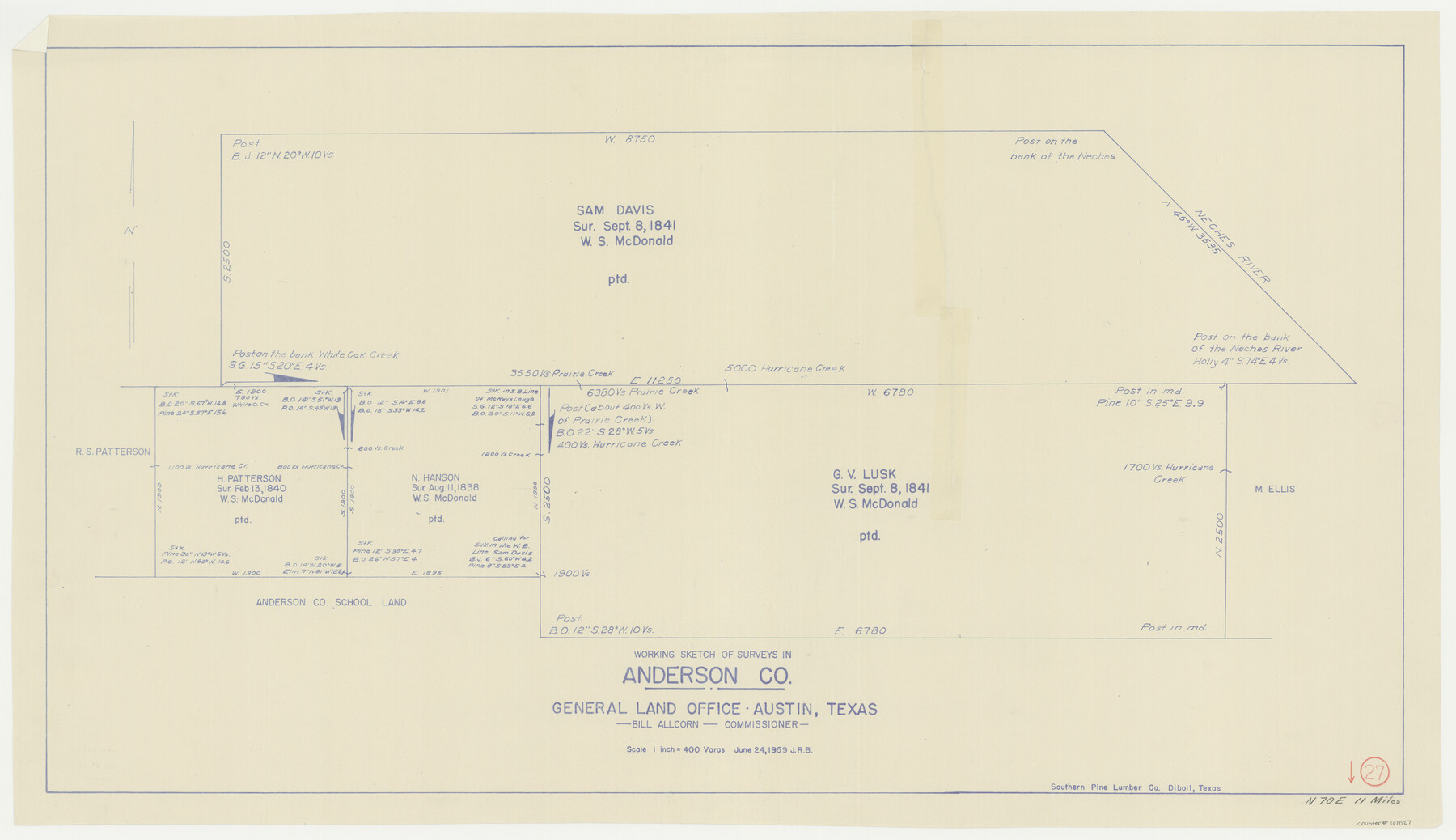
Anderson County Working Sketch 27
-
Map/Doc
67027
-
Collection
General Map Collection
-
Object Dates
6/24/1959 (Creation Date)
-
People and Organizations
Bill Allcorn (GLO Commissioner)
-
Counties
Anderson
-
Subjects
Surveying Working Sketch
-
Height x Width
20.8 x 36.0 inches
52.8 x 91.4 cm
-
Scale
1" = 400 varas
-
Comments
Surveys located about 11 miles North 70 degrees East of Palestine, Texas.
Part of: General Map Collection
Angelina County Sketch File 15a

Print $8.00
- Digital $50.00
Angelina County Sketch File 15a
1857
Size 12.3 x 8.2 inches
Map/Doc 12964
Flight Mission No. DQO-3K, Frame 37, Galveston County

Print $20.00
- Digital $50.00
Flight Mission No. DQO-3K, Frame 37, Galveston County
1952
Size 18.7 x 22.6 inches
Map/Doc 85078
Cooke County Boundary File 1

Print $4.00
- Digital $50.00
Cooke County Boundary File 1
Size 12.6 x 7.5 inches
Map/Doc 51826
Karnes County Sketch File 7a

Print $4.00
- Digital $50.00
Karnes County Sketch File 7a
1873
Size 10.1 x 8.1 inches
Map/Doc 28563
Hays County Boundary File 3

Print $20.00
- Digital $50.00
Hays County Boundary File 3
Size 11.2 x 8.8 inches
Map/Doc 54597
Irion County Working Sketch 2

Print $20.00
- Digital $50.00
Irion County Working Sketch 2
1921
Size 34.2 x 20.6 inches
Map/Doc 66411
Leon County Working Sketch 5

Print $20.00
- Digital $50.00
Leon County Working Sketch 5
1905
Size 40.5 x 20.6 inches
Map/Doc 70404
FT. W. & R. G. Ry. Right of Way Map, Winchell to Brady, McCulloch County, Texas

Print $40.00
- Digital $50.00
FT. W. & R. G. Ry. Right of Way Map, Winchell to Brady, McCulloch County, Texas
1918
Size 38.0 x 121.9 inches
Map/Doc 61410
Anderson County Working Sketch 40

Print $20.00
- Digital $50.00
Anderson County Working Sketch 40
1986
Size 17.0 x 20.3 inches
Map/Doc 67040
Houston County Sketch File 9

Print $4.00
- Digital $50.00
Houston County Sketch File 9
1857
Size 12.7 x 8.1 inches
Map/Doc 26771
Flight Mission No. DQO-3K, Frame 82, Galveston County

Print $20.00
- Digital $50.00
Flight Mission No. DQO-3K, Frame 82, Galveston County
1952
Size 18.7 x 22.5 inches
Map/Doc 85087
Grimes County Working Sketch 6

Print $20.00
- Digital $50.00
Grimes County Working Sketch 6
1951
Size 33.2 x 33.4 inches
Map/Doc 63297
You may also like
Flight Mission No. DQN-7K, Frame 4, Calhoun County

Print $20.00
- Digital $50.00
Flight Mission No. DQN-7K, Frame 4, Calhoun County
1953
Size 18.9 x 22.1 inches
Map/Doc 84455

[Blocks M18, M23, I, Z, and Block 47, Sections 16 - 28]
![91175, [Blocks M18, M23, I, Z, and Block 47, Sections 16 - 28], Twichell Survey Records](https://historictexasmaps.com/wmedia_w700/maps/91175-1.tif.jpg)
Print $20.00
- Digital $50.00
[Blocks M18, M23, I, Z, and Block 47, Sections 16 - 28]
Size 18.9 x 24.3 inches
Map/Doc 91175
Goliad County Sketch File 3

Print $4.00
- Digital $50.00
Goliad County Sketch File 3
1852
Size 12.4 x 8.2 inches
Map/Doc 24214
Liberty County Sketch File 63

Print $138.00
- Digital $50.00
Liberty County Sketch File 63
1983
Size 11.1 x 8.8 inches
Map/Doc 30087

San Jacinto County Sketch File 12

Print $4.00
San Jacinto County Sketch File 12
1873
Size 9.7 x 8.2 inches
Map/Doc 35720
Atascosa County Working Sketch 39

Print $20.00
- Digital $50.00
Atascosa County Working Sketch 39
2011
Size 43.2 x 34.8 inches
Map/Doc 90068
Brewster County Working Sketch 4

Print $20.00
- Digital $50.00
Brewster County Working Sketch 4
1908
Size 15.7 x 20.5 inches
Map/Doc 67537
Brewster County Rolled Sketch 83A

Print $40.00
- Digital $50.00
Brewster County Rolled Sketch 83A
1946
Size 43.0 x 49.5 inches
Map/Doc 8930
Map of Ellis County

Print $20.00
- Digital $50.00
Map of Ellis County
1871
Size 19.2 x 27.1 inches
Map/Doc 3509
Flight Mission No. CRE-2R, Frame 83, Jackson County

Print $20.00
- Digital $50.00
Flight Mission No. CRE-2R, Frame 83, Jackson County
1956
Size 18.6 x 22.3 inches
Map/Doc 85355