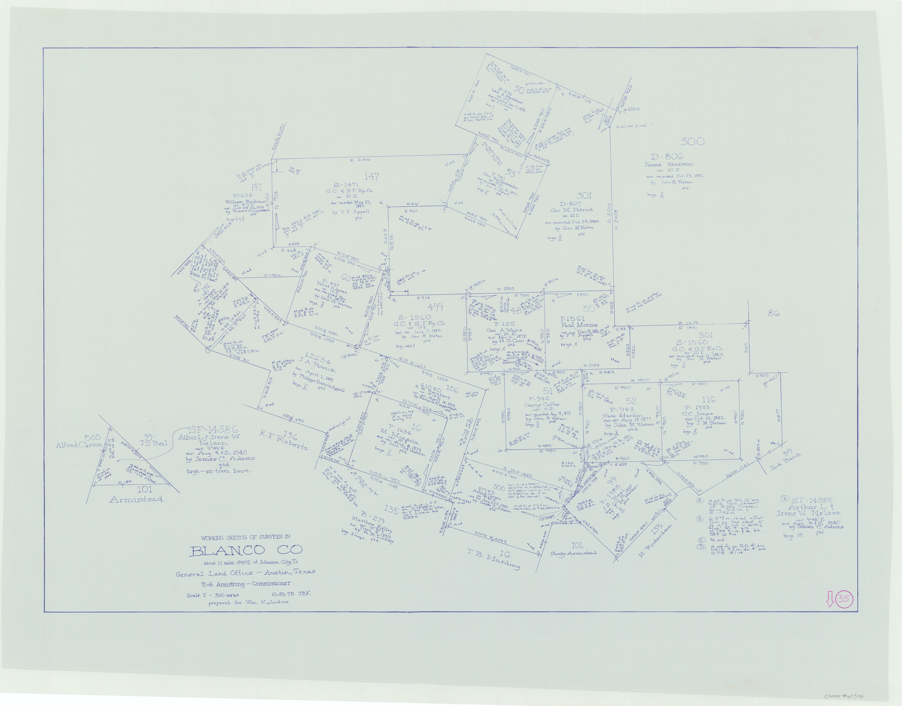
Blanco County Working Sketch 35
-
Map/Doc
67395
-
Collection
General Map Collection
-
Object Dates
10/25/1978 (Creation Date)
-
People and Organizations
Joan Kilpatrick (Draftsman)
Bob Armstrong (GLO Commissioner)
-
Counties
Blanco
-
Subjects
Surveying Working Sketch
-
Height x Width
28.7 x 36.6 inches
72.9 x 93.0 cm
-
Scale
1" = 300 varas
-
Comments
Surveys located about 11 miles South 45 degrees East of Johnson City, Texas.
Part of: General Map Collection
Presidio County Rolled Sketch 131A

Print $20.00
- Digital $50.00
Presidio County Rolled Sketch 131A
1992
Size 36.5 x 46.7 inches
Map/Doc 9802
The First Part of Captn. Pike's Chart of the Internal Part of Louisiana

Print $20.00
- Digital $50.00
The First Part of Captn. Pike's Chart of the Internal Part of Louisiana
1810
Size 19.6 x 21.2 inches
Map/Doc 95154
Travis District No. 4 Head of Walnut Creek

Print $2.00
- Digital $50.00
Travis District No. 4 Head of Walnut Creek
1846
Size 4.0 x 8.2 inches
Map/Doc 78382
Coleman County Sketch File 34

Print $28.00
- Digital $50.00
Coleman County Sketch File 34
1878
Size 12.8 x 8.1 inches
Map/Doc 18726
San Angelo/Big Spring, Texas Street Map "A Traveler's Best Friend"

San Angelo/Big Spring, Texas Street Map "A Traveler's Best Friend"
Size 37.6 x 25.0 inches
Map/Doc 94400
Stonewall County Working Sketch 18

Print $20.00
- Digital $50.00
Stonewall County Working Sketch 18
1956
Size 24.0 x 21.6 inches
Map/Doc 62325
[Texas Gulf Coast from Rio Grande to Sabine Lake]
![72688, [Texas Gulf Coast from Rio Grande to Sabine Lake], General Map Collection](https://historictexasmaps.com/wmedia_w700/maps/72688.tif.jpg)
Print $20.00
- Digital $50.00
[Texas Gulf Coast from Rio Grande to Sabine Lake]
Size 27.8 x 18.3 inches
Map/Doc 72688
Leon County Working Sketch 3

Print $20.00
- Digital $50.00
Leon County Working Sketch 3
1920
Size 15.9 x 14.4 inches
Map/Doc 70402
Lynn County Sketch File 6

Print $20.00
- Digital $50.00
Lynn County Sketch File 6
1928
Size 24.2 x 36.7 inches
Map/Doc 10529
Runnels County Rolled Sketch 29

Print $20.00
- Digital $50.00
Runnels County Rolled Sketch 29
1928
Size 19.6 x 37.0 inches
Map/Doc 7517
Flight Mission No. CGI-3N, Frame 49, Cameron County

Print $20.00
- Digital $50.00
Flight Mission No. CGI-3N, Frame 49, Cameron County
1954
Size 18.8 x 22.4 inches
Map/Doc 84555
Dawson County Sketch File 15

Print $40.00
- Digital $50.00
Dawson County Sketch File 15
Size 17.8 x 7.9 inches
Map/Doc 20549
You may also like
Texas Intracoastal Waterway, Aransas Bay to Aransas Pass

Print $20.00
- Digital $50.00
Texas Intracoastal Waterway, Aransas Bay to Aransas Pass
1962
Size 26.8 x 38.7 inches
Map/Doc 73438
Donley County Sketch File 26

Print $6.00
- Digital $50.00
Donley County Sketch File 26
Size 12.8 x 8.3 inches
Map/Doc 21261
Current Miscellaneous File 13

Print $20.00
- Digital $50.00
Current Miscellaneous File 13
Size 16.2 x 21.6 inches
Map/Doc 73820
Cass County Working Sketch 53

Print $20.00
- Digital $50.00
Cass County Working Sketch 53
2007
Size 30.2 x 36.0 inches
Map/Doc 88608
Schleicher County Working Sketch 23

Print $20.00
- Digital $50.00
Schleicher County Working Sketch 23
1953
Size 42.6 x 40.6 inches
Map/Doc 63825
Runnels County Rolled Sketch 40

Print $20.00
- Digital $50.00
Runnels County Rolled Sketch 40
Size 32.3 x 38.9 inches
Map/Doc 7528
[Area Surrounding Charles Ragsdale, M. George, and H. Ward Surveys]
![91535, [Area Surrounding Charles Ragsdale, M. George, and H. Ward Surveys], Twichell Survey Records](https://historictexasmaps.com/wmedia_w700/maps/91535-1.tif.jpg)
Print $20.00
- Digital $50.00
[Area Surrounding Charles Ragsdale, M. George, and H. Ward Surveys]
Size 20.0 x 23.3 inches
Map/Doc 91535
Stonewall County Working Sketch 29

Print $40.00
- Digital $50.00
Stonewall County Working Sketch 29
1979
Size 48.5 x 43.0 inches
Map/Doc 62336
La Salle County Working Sketch 7

Print $20.00
- Digital $50.00
La Salle County Working Sketch 7
1922
Size 35.0 x 36.5 inches
Map/Doc 70308
Flight Mission No. DQN-5K, Frame 52, Calhoun County

Print $20.00
- Digital $50.00
Flight Mission No. DQN-5K, Frame 52, Calhoun County
1953
Size 18.6 x 22.3 inches
Map/Doc 84397
Moore County Rolled Sketch 3

Print $20.00
- Digital $50.00
Moore County Rolled Sketch 3
Size 12.3 x 15.3 inches
Map/Doc 6823
Kimble County Working Sketch 65

Print $20.00
- Digital $50.00
Kimble County Working Sketch 65
1964
Size 22.1 x 17.0 inches
Map/Doc 70133