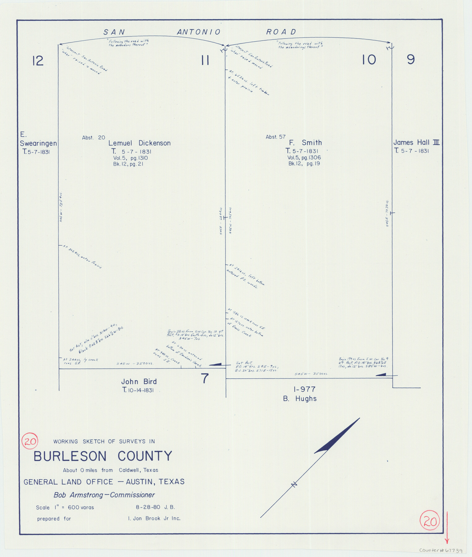
Burleson County Working Sketch 20
-
Map/Doc
67739
-
Collection
General Map Collection
-
Object Dates
8/28/1980 (Creation Date)
-
Counties
Burleson
-
Subjects
Surveying Working Sketch
-
Height x Width
19.5 x 16.6 inches
49.5 x 42.2 cm
-
Scale
1" = 600 varas
Part of: General Map Collection
Edwards County Boundary File 27 1/2a

Print $56.00
- Digital $50.00
Edwards County Boundary File 27 1/2a
Size 14.1 x 8.8 inches
Map/Doc 52922
Location of the Southern Kansas Railway of Texas through Hemphill County, Texas

Print $40.00
- Digital $50.00
Location of the Southern Kansas Railway of Texas through Hemphill County, Texas
1887
Size 20.2 x 91.8 inches
Map/Doc 64000
Castro County Sketch File 5

Print $20.00
- Digital $50.00
Castro County Sketch File 5
Size 37.6 x 25.3 inches
Map/Doc 11058
Preliminary Chart of Galveston Bay, Texas

Print $20.00
- Digital $50.00
Preliminary Chart of Galveston Bay, Texas
1855
Size 20.9 x 17.5 inches
Map/Doc 69868
Cameron County Rolled Sketch US1

Print $20.00
- Digital $50.00
Cameron County Rolled Sketch US1
1913
Size 21.2 x 25.3 inches
Map/Doc 5399
Brazoria County Working Sketch 5

Print $20.00
- Digital $50.00
Brazoria County Working Sketch 5
1921
Size 15.1 x 17.1 inches
Map/Doc 67490
Real County Working Sketch 10

Print $20.00
- Digital $50.00
Real County Working Sketch 10
1929
Size 23.0 x 15.4 inches
Map/Doc 71902
Stephens County Rolled Sketch 3

Print $20.00
- Digital $50.00
Stephens County Rolled Sketch 3
1919
Size 34.9 x 19.6 inches
Map/Doc 7840
Gillespie County

Print $40.00
- Digital $50.00
Gillespie County
1887
Size 44.1 x 59.7 inches
Map/Doc 16835
Tom Green County Sketch File 16

Print $16.00
- Digital $50.00
Tom Green County Sketch File 16
Size 8.5 x 7.8 inches
Map/Doc 38174
Galveston County NRC Article 33.136 Sketch 23

Print $22.00
- Digital $50.00
Galveston County NRC Article 33.136 Sketch 23
2002
Size 11.4 x 16.4 inches
Map/Doc 81905
Galveston Co.

Print $40.00
- Digital $50.00
Galveston Co.
1891
Size 38.5 x 53.8 inches
Map/Doc 66834
You may also like
Bexar County Working Sketch 13

Print $20.00
- Digital $50.00
Bexar County Working Sketch 13
1968
Size 43.5 x 43.7 inches
Map/Doc 67329
General Highway Map, Kenedy County, Texas

Print $20.00
General Highway Map, Kenedy County, Texas
1961
Size 18.1 x 24.6 inches
Map/Doc 79447
English Field Notes of the Spanish Archives - Book 8

English Field Notes of the Spanish Archives - Book 8
1835
Map/Doc 96534
Right of Way and Track Map of The Missouri, Kansas & Texas Railway of Texas

Print $40.00
- Digital $50.00
Right of Way and Track Map of The Missouri, Kansas & Texas Railway of Texas
1918
Size 25.2 x 51.6 inches
Map/Doc 64530
Live Oak County Sketch File 1

Print $4.00
- Digital $50.00
Live Oak County Sketch File 1
1856
Size 11.5 x 7.8 inches
Map/Doc 30251
General Highway Map, Coke County, Texas

Print $20.00
General Highway Map, Coke County, Texas
1961
Size 18.2 x 24.7 inches
Map/Doc 79411
Limestone County Sketch File 7

Print $4.00
- Digital $50.00
Limestone County Sketch File 7
1862
Size 13.3 x 7.9 inches
Map/Doc 30169
Flight Mission No. CRC-4R, Frame 104, Chambers County

Print $20.00
- Digital $50.00
Flight Mission No. CRC-4R, Frame 104, Chambers County
1956
Size 18.6 x 22.4 inches
Map/Doc 84901
Flight Mission No. CRC-5R, Frame 32, Chambers County

Print $20.00
- Digital $50.00
Flight Mission No. CRC-5R, Frame 32, Chambers County
1956
Size 18.5 x 22.4 inches
Map/Doc 84951
[Sketch showing details along East line of Lipscomb County]
![89968, [Sketch showing details along East line of Lipscomb County], Twichell Survey Records](https://historictexasmaps.com/wmedia_w700/maps/89968-1.tif.jpg)
Print $40.00
- Digital $50.00
[Sketch showing details along East line of Lipscomb County]
Size 9.9 x 66.3 inches
Map/Doc 89968
Denison, Grayson County, Texas

Print $20.00
- Digital $50.00
Denison, Grayson County, Texas
1891
Size 23.7 x 35.7 inches
Map/Doc 97032
Live Oak County Working Sketch 22

Print $40.00
- Digital $50.00
Live Oak County Working Sketch 22
1976
Size 63.1 x 31.9 inches
Map/Doc 70607