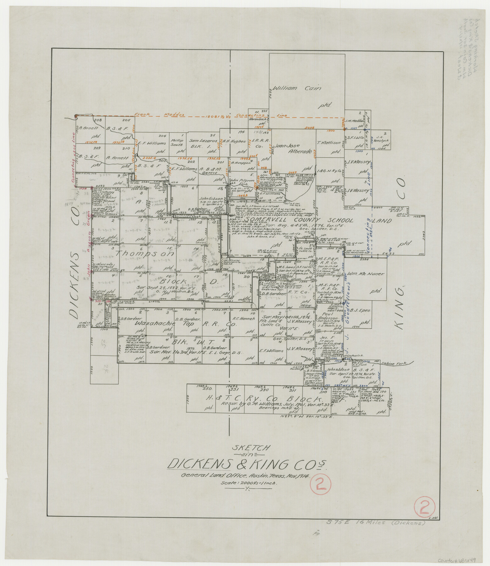
Dickens County Working Sketch 2
-
Map/Doc
68649
-
Collection
General Map Collection
-
Object Dates
11/1914 (Creation Date)
-
People and Organizations
Leo Ehlinger (Draftsman)
-
Counties
Dickens King
-
Subjects
Surveying Working Sketch
-
Height x Width
19.1 x 16.6 inches
48.5 x 42.2 cm
-
Scale
1" = 2000 varas
Part of: General Map Collection
Glasscock County

Print $20.00
- Digital $50.00
Glasscock County
1933
Size 41.1 x 34.7 inches
Map/Doc 77290
Flight Mission No. DCL-7C, Frame 145, Kenedy County

Print $20.00
- Digital $50.00
Flight Mission No. DCL-7C, Frame 145, Kenedy County
1943
Size 18.6 x 22.5 inches
Map/Doc 86102
FT. W. & R. G. Ry. Right of Way Map, Whiteland to Lightner, Concho County, Texas

Print $40.00
- Digital $50.00
FT. W. & R. G. Ry. Right of Way Map, Whiteland to Lightner, Concho County, Texas
1918
Size 37.5 x 68.4 inches
Map/Doc 61413
Hunt County Sketch File 32

Print $6.00
- Digital $50.00
Hunt County Sketch File 32
Size 7.9 x 11.6 inches
Map/Doc 27138
Connected Map of Austin's Colony

Print $20.00
- Digital $50.00
Connected Map of Austin's Colony
1892
Size 47.3 x 43.3 inches
Map/Doc 76075
Intracoastal Waterway - Galveston Bay to West Bay including Galveston Bay Entrance

Print $20.00
- Digital $50.00
Intracoastal Waterway - Galveston Bay to West Bay including Galveston Bay Entrance
1961
Size 26.7 x 38.7 inches
Map/Doc 69934
Medina County Working Sketch 20

Print $20.00
- Digital $50.00
Medina County Working Sketch 20
1980
Size 25.4 x 39.2 inches
Map/Doc 70935
Lamb County Working Sketch 3

Print $20.00
- Digital $50.00
Lamb County Working Sketch 3
1962
Size 32.1 x 37.7 inches
Map/Doc 70276
Concho County Rolled Sketch 20

Print $20.00
- Digital $50.00
Concho County Rolled Sketch 20
1968
Size 26.2 x 38.8 inches
Map/Doc 5554

Kinney County Rolled Sketch 11

Print $20.00
- Digital $50.00
Kinney County Rolled Sketch 11
1944
Size 39.2 x 32.0 inches
Map/Doc 6540
Harrison County Boundary File 2

Print $40.00
- Digital $50.00
Harrison County Boundary File 2
Size 22.6 x 7.7 inches
Map/Doc 54416
You may also like
Throckmorton County Rolled Sketch 3B

Print $20.00
- Digital $50.00
Throckmorton County Rolled Sketch 3B
Size 31.3 x 37.9 inches
Map/Doc 7988
Plat Showing Part of Block Y, W. D. and F. W. Johnson Subdivision Number 2; and Part of Block W, Edward K. Warren Subdivision Number 1

Print $20.00
- Digital $50.00
Plat Showing Part of Block Y, W. D. and F. W. Johnson Subdivision Number 2; and Part of Block W, Edward K. Warren Subdivision Number 1
1954
Size 23.3 x 17.4 inches
Map/Doc 92502
Anderson County Working Sketch 5

Print $20.00
- Digital $50.00
Anderson County Working Sketch 5
1913
Size 15.0 x 15.3 inches
Map/Doc 67004
Webb County Sketch File 49

Print $20.00
- Digital $50.00
Webb County Sketch File 49
1939
Size 20.7 x 21.5 inches
Map/Doc 12647
Presidio County Rolled Sketch 131A

Print $20.00
- Digital $50.00
Presidio County Rolled Sketch 131A
Size 47.5 x 36.6 inches
Map/Doc 10711
Edwards County Rolled Sketch 17

Print $20.00
- Digital $50.00
Edwards County Rolled Sketch 17
1945
Size 27.6 x 19.4 inches
Map/Doc 5806

Presidio County Sketch File 105

Print $20.00
- Digital $50.00
Presidio County Sketch File 105
Size 13.1 x 20.6 inches
Map/Doc 82962
El Nuevo Mexico y Tierras Adyacentes Mapa Levantado para la demarcacion de los Limites de los Dominios Españoles y de los Estados Unidos por el P.D. Jose Pichardo quien lo dedica al Exmo. Sor. D. Fracisco Xavier Venegas Virrey de esta N.E. &. Año de 1811

Print $40.00
El Nuevo Mexico y Tierras Adyacentes Mapa Levantado para la demarcacion de los Limites de los Dominios Españoles y de los Estados Unidos por el P.D. Jose Pichardo quien lo dedica al Exmo. Sor. D. Fracisco Xavier Venegas Virrey de esta N.E. &. Año de 1811
1811
Size 35.8 x 49.6 inches
Map/Doc 95360
Crockett County Rolled Sketch 69

Print $40.00
- Digital $50.00
Crockett County Rolled Sketch 69
1949
Size 39.4 x 54.8 inches
Map/Doc 8721
[Block B9 and 3KA]
![90483, [Block B9 and 3KA], Twichell Survey Records](https://historictexasmaps.com/wmedia_w700/maps/90483-1.tif.jpg)
Print $20.00
- Digital $50.00
[Block B9 and 3KA]
Size 23.6 x 16.3 inches
Map/Doc 90483
Walker County Miscellaneous Sketch 1

Print $20.00
- Digital $50.00
Walker County Miscellaneous Sketch 1
2003
Size 36.0 x 31.3 inches
Map/Doc 88868