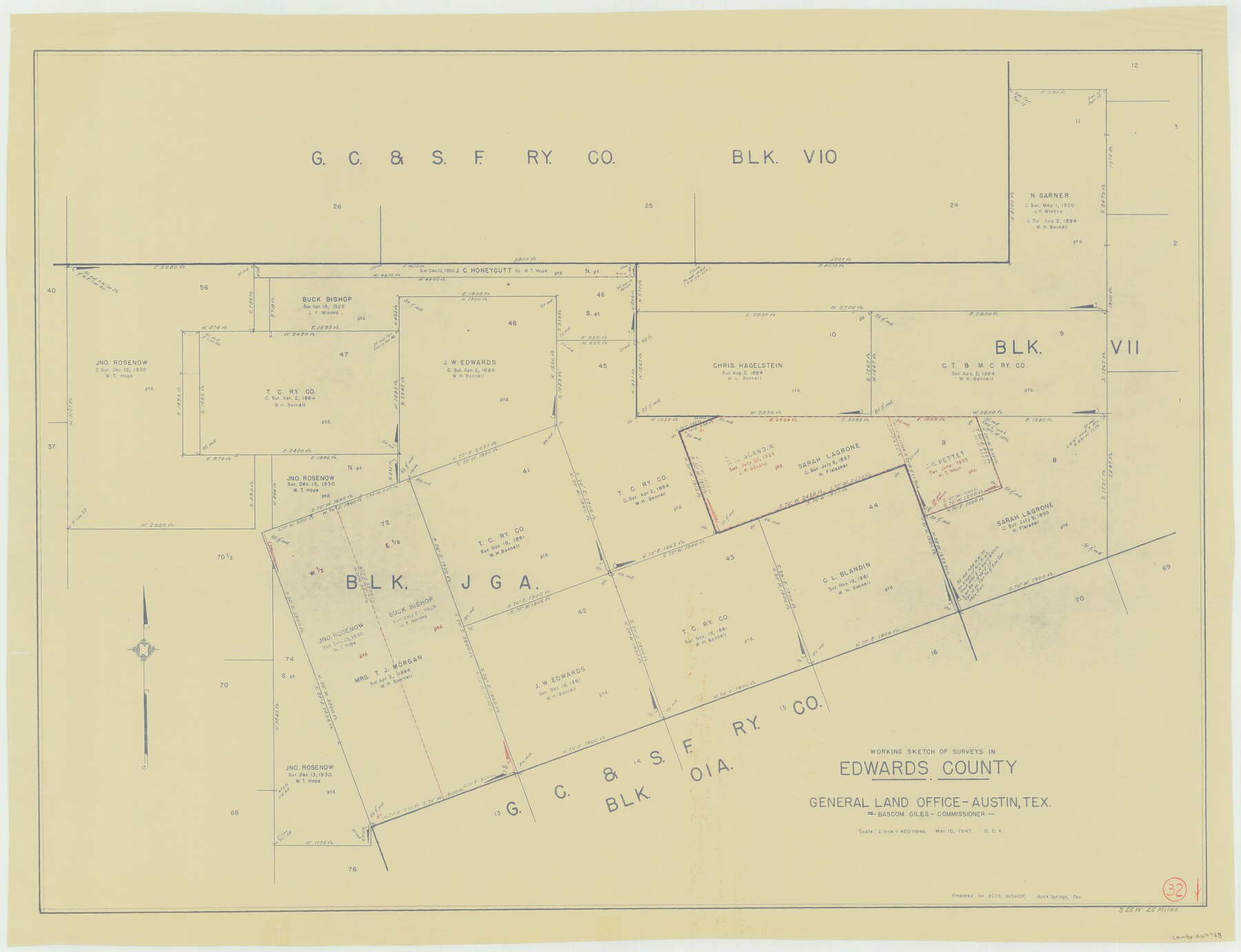
Edwards County Working Sketch 32
-
Map/Doc
68908
-
Collection
General Map Collection
-
Object Dates
3/10/1947 (Creation Date)
-
People and Organizations
Otto G. Kurio (Draftsman)
-
Counties
Edwards
-
Subjects
Surveying Working Sketch
-
Height x Width
28.9 x 37.7 inches
73.4 x 95.8 cm
-
Scale
1" = 400 varas
Part of: General Map Collection
Castro County Working Sketch 5

Print $20.00
- Digital $50.00
Castro County Working Sketch 5
1943
Size 11.9 x 18.3 inches
Map/Doc 67900
Johnson County Sketch File 22

Print $20.00
- Digital $50.00
Johnson County Sketch File 22
1873
Size 18.8 x 16.2 inches
Map/Doc 11891
Kerr County Sketch File 21

Print $10.00
- Digital $50.00
Kerr County Sketch File 21
1954
Size 11.1 x 8.7 inches
Map/Doc 28892
Walker County Sketch File 8

Print $4.00
- Digital $50.00
Walker County Sketch File 8
1944
Size 9.7 x 6.8 inches
Map/Doc 39561
Midland County Working Sketch 32

Print $40.00
- Digital $50.00
Midland County Working Sketch 32
1971
Size 51.3 x 35.5 inches
Map/Doc 71013
Mitchell's school atlas: comprising the maps, etc., designed to illustrate Mitchell's school and family geography

Print $370.00
- Digital $50.00
Mitchell's school atlas: comprising the maps, etc., designed to illustrate Mitchell's school and family geography
1851
Size 12.0 x 9.6 inches
Map/Doc 93491
Map of the Passo Cavallo on the entrance into Matagorda Bay from the Gulf of Mexico

Print $20.00
- Digital $50.00
Map of the Passo Cavallo on the entrance into Matagorda Bay from the Gulf of Mexico
1853
Size 17.8 x 27.3 inches
Map/Doc 73012
Sherman County Sketch File 8

Print $61.00
- Digital $50.00
Sherman County Sketch File 8
1993
Size 11.4 x 8.9 inches
Map/Doc 36726
Crockett County Rolled Sketch 69

Print $40.00
- Digital $50.00
Crockett County Rolled Sketch 69
1949
Size 39.4 x 54.8 inches
Map/Doc 8721
Schleicher County Sketch File 15

Print $22.00
- Digital $50.00
Schleicher County Sketch File 15
1928
Size 8.1 x 12.9 inches
Map/Doc 36504
Colorado County Working Sketch 5

Print $40.00
- Digital $50.00
Colorado County Working Sketch 5
1919
Size 82.4 x 44.1 inches
Map/Doc 68105
Stephens County

Print $20.00
- Digital $50.00
Stephens County
1940
Size 40.3 x 38.9 inches
Map/Doc 77426
You may also like
Titus County Sketch File 11

Print $4.00
- Digital $50.00
Titus County Sketch File 11
1872
Size 8.2 x 10.1 inches
Map/Doc 38150
Runnels County Rolled Sketch 33

Print $20.00
- Digital $50.00
Runnels County Rolled Sketch 33
Size 22.5 x 43.5 inches
Map/Doc 7520
[Blocks M-22, M-25 and vicinity]
![91235, [Blocks M-22, M-25 and vicinity], Twichell Survey Records](https://historictexasmaps.com/wmedia_w700/maps/91235-1.tif.jpg)
Print $20.00
- Digital $50.00
[Blocks M-22, M-25 and vicinity]
Size 27.4 x 25.2 inches
Map/Doc 91235
Milam County Working Sketch 11

Print $20.00
- Digital $50.00
Milam County Working Sketch 11
1987
Size 43.8 x 31.9 inches
Map/Doc 71026
Edwards County Rolled Sketch 7

Print $20.00
- Digital $50.00
Edwards County Rolled Sketch 7
1881
Size 24.4 x 23.2 inches
Map/Doc 5800
Comal County Rolled Sketch 6

Print $4.00
- Digital $50.00
Comal County Rolled Sketch 6
1988
Size 25.0 x 19.1 inches
Map/Doc 5541
Coleman County Working Sketch 9

Print $20.00
- Digital $50.00
Coleman County Working Sketch 9
1950
Size 24.9 x 30.5 inches
Map/Doc 68075
Bandera County Working Sketch 10

Print $20.00
- Digital $50.00
Bandera County Working Sketch 10
1922
Size 17.9 x 19.4 inches
Map/Doc 67603
Montgomery Co.

Print $40.00
- Digital $50.00
Montgomery Co.
1943
Size 45.1 x 53.3 inches
Map/Doc 66940
King County Sketch File 9

Print $20.00
- Digital $50.00
King County Sketch File 9
Size 23.5 x 33.0 inches
Map/Doc 11937
No. 2 Chart of Corpus Christi Pass, Texas

Print $20.00
- Digital $50.00
No. 2 Chart of Corpus Christi Pass, Texas
1878
Size 18.2 x 27.3 inches
Map/Doc 73027
McMullen County Sketch File 36

Print $8.00
- Digital $50.00
McMullen County Sketch File 36
Size 4.8 x 8.2 inches
Map/Doc 31406