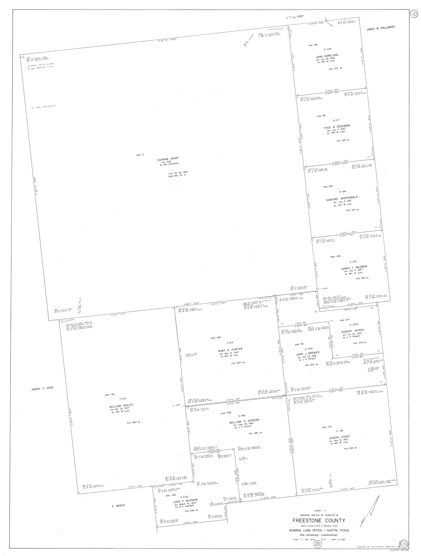
Freestone County Working Sketch 20
-
Map/Doc
69262
-
Collection
General Map Collection
-
Object Dates
3/12/1980 (Creation Date)
-
People and Organizations
Beverly Robison (Draftsman)
-
Counties
Freestone
-
Subjects
Surveying Working Sketch
-
Height x Width
52.4 x 39.6 inches
133.1 x 100.6 cm
-
Scale
1" = 200 varas
Part of: General Map Collection
Clay County Sketch File 31

Print $4.00
- Digital $50.00
Clay County Sketch File 31
Size 10.2 x 8.0 inches
Map/Doc 18456
[Surveys along Cypress Creek]
![155, [Surveys along Cypress Creek], General Map Collection](https://historictexasmaps.com/wmedia_w700/maps/155.tif.jpg)
Print $2.00
- Digital $50.00
[Surveys along Cypress Creek]
1844
Size 6.0 x 6.1 inches
Map/Doc 155
Flight Mission No. DAG-21K, Frame 43, Matagorda County

Print $20.00
- Digital $50.00
Flight Mission No. DAG-21K, Frame 43, Matagorda County
1952
Size 18.9 x 22.6 inches
Map/Doc 86410
San Patricio County Sketch File 44

Print $12.00
- Digital $50.00
San Patricio County Sketch File 44
1942
Size 11.4 x 8.9 inches
Map/Doc 36267
United States - Gulf Coast - Galveston to Rio Grande

Print $20.00
- Digital $50.00
United States - Gulf Coast - Galveston to Rio Grande
1919
Size 26.7 x 18.3 inches
Map/Doc 72746
Intracoastal Waterway, Houma, LA to Corpus Christi, TX

Print $20.00
- Digital $50.00
Intracoastal Waterway, Houma, LA to Corpus Christi, TX
Size 22.0 x 25.0 inches
Map/Doc 61905
Zapata County Sketch File 20

Print $633.00
- Digital $50.00
Zapata County Sketch File 20
1998
Size 11.5 x 8.9 inches
Map/Doc 40966
Bandera County Working Sketch 16d

Print $20.00
- Digital $50.00
Bandera County Working Sketch 16d
1941
Size 19.1 x 23.2 inches
Map/Doc 67612
Morris County Rolled Sketch 2A

Print $20.00
- Digital $50.00
Morris County Rolled Sketch 2A
Size 24.0 x 18.7 inches
Map/Doc 10280
Flight Mission No. CGI-3N, Frame 142, Cameron County

Print $20.00
- Digital $50.00
Flight Mission No. CGI-3N, Frame 142, Cameron County
1954
Size 18.7 x 22.3 inches
Map/Doc 84615
Pecos County Rolled Sketch 64

Print $20.00
- Digital $50.00
Pecos County Rolled Sketch 64
Size 16.4 x 26.5 inches
Map/Doc 7235
Brewster County Rolled Sketch 114

Print $20.00
- Digital $50.00
Brewster County Rolled Sketch 114
1964
Size 11.4 x 17.7 inches
Map/Doc 5284
You may also like
Winkler County Sketch File 10

Print $4.00
- Digital $50.00
Winkler County Sketch File 10
1910
Size 9.1 x 8.3 inches
Map/Doc 40486
Calhoun County Rolled Sketch 2

Print $20.00
- Digital $50.00
Calhoun County Rolled Sketch 2
Size 23.1 x 22.4 inches
Map/Doc 5360
[Sketch of surveys in Hutchinson County]
![75817, [Sketch of surveys in Hutchinson County], Maddox Collection](https://historictexasmaps.com/wmedia_w700/maps/75817.tif.jpg)
Print $20.00
- Digital $50.00
[Sketch of surveys in Hutchinson County]
1912
Size 25.0 x 26.8 inches
Map/Doc 75817
Glasscock County Sketch File 10

Print $6.00
- Digital $50.00
Glasscock County Sketch File 10
1935
Size 11.6 x 12.8 inches
Map/Doc 24172
San Jacinto County Working Sketch 38

Print $40.00
- Digital $50.00
San Jacinto County Working Sketch 38
1966
Size 41.5 x 55.9 inches
Map/Doc 63751
Secs. 58-69, I&GN Blk. 1

Print $20.00
- Digital $50.00
Secs. 58-69, I&GN Blk. 1
Size 27.5 x 25.3 inches
Map/Doc 91617
I. & G. N. - International and Great Northern R.R. - International Route - Galveston, Ft. Worth, Waco, Houston, Austin, Laredo, San Antonio

Print $20.00
- Digital $50.00
I. & G. N. - International and Great Northern R.R. - International Route - Galveston, Ft. Worth, Waco, Houston, Austin, Laredo, San Antonio
1910
Size 24.0 x 16.2 inches
Map/Doc 95779
Liberty County Working Sketch 57

Print $40.00
- Digital $50.00
Liberty County Working Sketch 57
1967
Size 52.6 x 40.6 inches
Map/Doc 70517
Duval County Working Sketch 20

Print $20.00
- Digital $50.00
Duval County Working Sketch 20
1940
Size 20.5 x 12.7 inches
Map/Doc 68733
Flight Mission No. DAH-17M, Frame 29, Orange County

Print $20.00
- Digital $50.00
Flight Mission No. DAH-17M, Frame 29, Orange County
1953
Size 18.7 x 22.5 inches
Map/Doc 86892
Guadalupe County

Print $20.00
- Digital $50.00
Guadalupe County
1977
Size 35.9 x 46.4 inches
Map/Doc 73165
Zavala County Working Sketch 20

Print $20.00
- Digital $50.00
Zavala County Working Sketch 20
1977
Size 40.0 x 34.5 inches
Map/Doc 62095