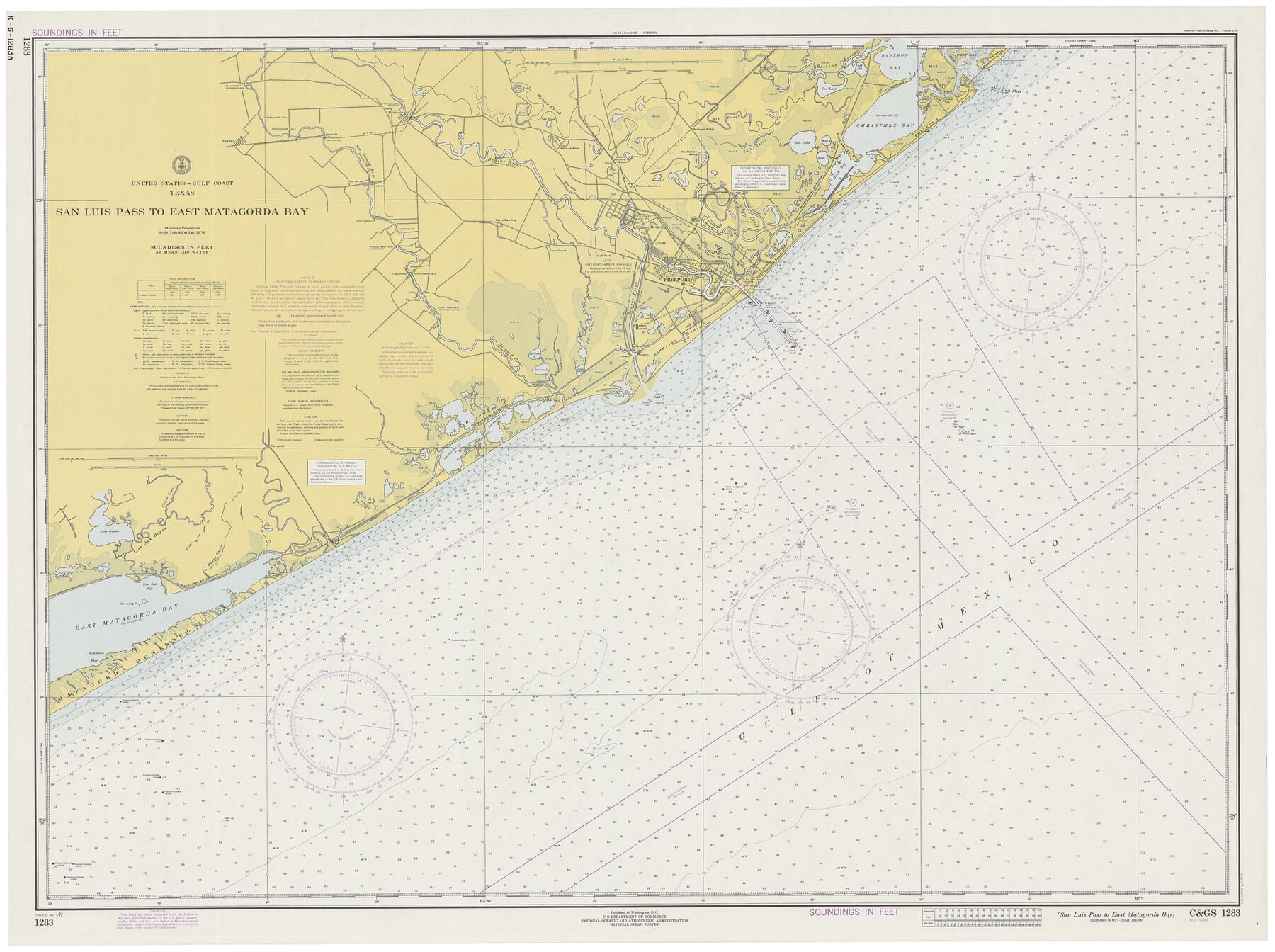
San Luis Pass to East Matagorda Bay
K-6-1283d
-
Map/Doc
69967
-
Collection
General Map Collection
-
Object Dates
4/1/1972 (Creation Date)
-
Counties
Galveston Matagorda Brazoria
-
Subjects
Nautical Charts
-
Height x Width
34.7 x 47.2 inches
88.1 x 119.9 cm
Part of: General Map Collection
Calhoun County NRC Article 33.136 Location Key Sheet

Print $20.00
- Digital $50.00
Calhoun County NRC Article 33.136 Location Key Sheet
1973
Size 27.0 x 23.0 inches
Map/Doc 87906
Motley County Working Sketch 9

Print $20.00
- Digital $50.00
Motley County Working Sketch 9
1984
Size 32.6 x 28.9 inches
Map/Doc 71214
Flight Mission No. CGI-3N, Frame 124, Cameron County

Print $20.00
- Digital $50.00
Flight Mission No. CGI-3N, Frame 124, Cameron County
1954
Size 18.5 x 22.2 inches
Map/Doc 84597
Dallas County Boundary File 4

Print $38.00
- Digital $50.00
Dallas County Boundary File 4
Size 8.9 x 3.9 inches
Map/Doc 52123
Brewster County Working Sketch 5

Print $20.00
- Digital $50.00
Brewster County Working Sketch 5
1908
Size 28.0 x 22.0 inches
Map/Doc 67538

Bee County Boundary File 2

Print $10.00
- Digital $50.00
Bee County Boundary File 2
Size 8.8 x 6.8 inches
Map/Doc 50435
Clay County Boundary File 8

Print $18.00
- Digital $50.00
Clay County Boundary File 8
Size 13.3 x 8.2 inches
Map/Doc 51384
Calcasieu Pass to Sabine Pass

Print $20.00
- Digital $50.00
Calcasieu Pass to Sabine Pass
1976
Size 44.6 x 35.3 inches
Map/Doc 69813
Roberts County Working Sketch 24

Print $20.00
- Digital $50.00
Roberts County Working Sketch 24
1981
Size 25.8 x 36.9 inches
Map/Doc 63550
Moore County Sketch File 2

Print $36.00
- Digital $50.00
Moore County Sketch File 2
Size 14.2 x 8.6 inches
Map/Doc 31929
Lynn County Boundary File 7a

Print $8.00
- Digital $50.00
Lynn County Boundary File 7a
Size 14.3 x 8.8 inches
Map/Doc 56647
You may also like
Flight Mission No. CGI-3N, Frame 163, Cameron County

Print $20.00
- Digital $50.00
Flight Mission No. CGI-3N, Frame 163, Cameron County
1954
Size 18.5 x 22.3 inches
Map/Doc 84627
Wise County Rolled Sketch 8

Print $20.00
- Digital $50.00
Wise County Rolled Sketch 8
Size 24.0 x 36.0 inches
Map/Doc 93554
Van Zandt County Sketch File 15a

Print $4.00
- Digital $50.00
Van Zandt County Sketch File 15a
1858
Size 6.7 x 8.1 inches
Map/Doc 39406
Cherokee County Boundary File 2

Print $11.00
- Digital $50.00
Cherokee County Boundary File 2
Size 16.1 x 9.9 inches
Map/Doc 51280
Fort Bend County State Real Property Sketch 5

Print $40.00
- Digital $50.00
Fort Bend County State Real Property Sketch 5
1988
Size 35.3 x 43.6 inches
Map/Doc 61679
Williamson County Sketch File 7

Print $4.00
- Digital $50.00
Williamson County Sketch File 7
1847
Size 12.7 x 7.7 inches
Map/Doc 40316
Jeff Davis County Working Sketch 45

Print $20.00
- Digital $50.00
Jeff Davis County Working Sketch 45
1990
Size 27.8 x 38.1 inches
Map/Doc 66540
[Survey 9, Block 9 Potter and Randall]
![91720, [Survey 9, Block 9 Potter and Randall], Twichell Survey Records](https://historictexasmaps.com/wmedia_w700/maps/91720-1.tif.jpg)
Print $20.00
- Digital $50.00
[Survey 9, Block 9 Potter and Randall]
Size 22.3 x 15.9 inches
Map/Doc 91720
Pocket Map Showing the Railroads, Street Railways, Manufactories, Deep Water Connections, Blocks and Subdivisions of the City of Houston

Print $20.00
Pocket Map Showing the Railroads, Street Railways, Manufactories, Deep Water Connections, Blocks and Subdivisions of the City of Houston
1890
Size 35.5 x 29.8 inches
Map/Doc 93487
Jackson County Sketch File 12a

Print $40.00
- Digital $50.00
Jackson County Sketch File 12a
Size 17.4 x 14.4 inches
Map/Doc 27658
Preliminary Chart No. 31 of the Sea Coast of the United States from Galveston Bay to Matagorda Bay, Texas

Print $20.00
- Digital $50.00
Preliminary Chart No. 31 of the Sea Coast of the United States from Galveston Bay to Matagorda Bay, Texas
1857
Size 22.7 x 38.7 inches
Map/Doc 69949
Blanco County Working Sketch 35

Print $20.00
- Digital $50.00
Blanco County Working Sketch 35
1978
Size 28.7 x 36.6 inches
Map/Doc 67395