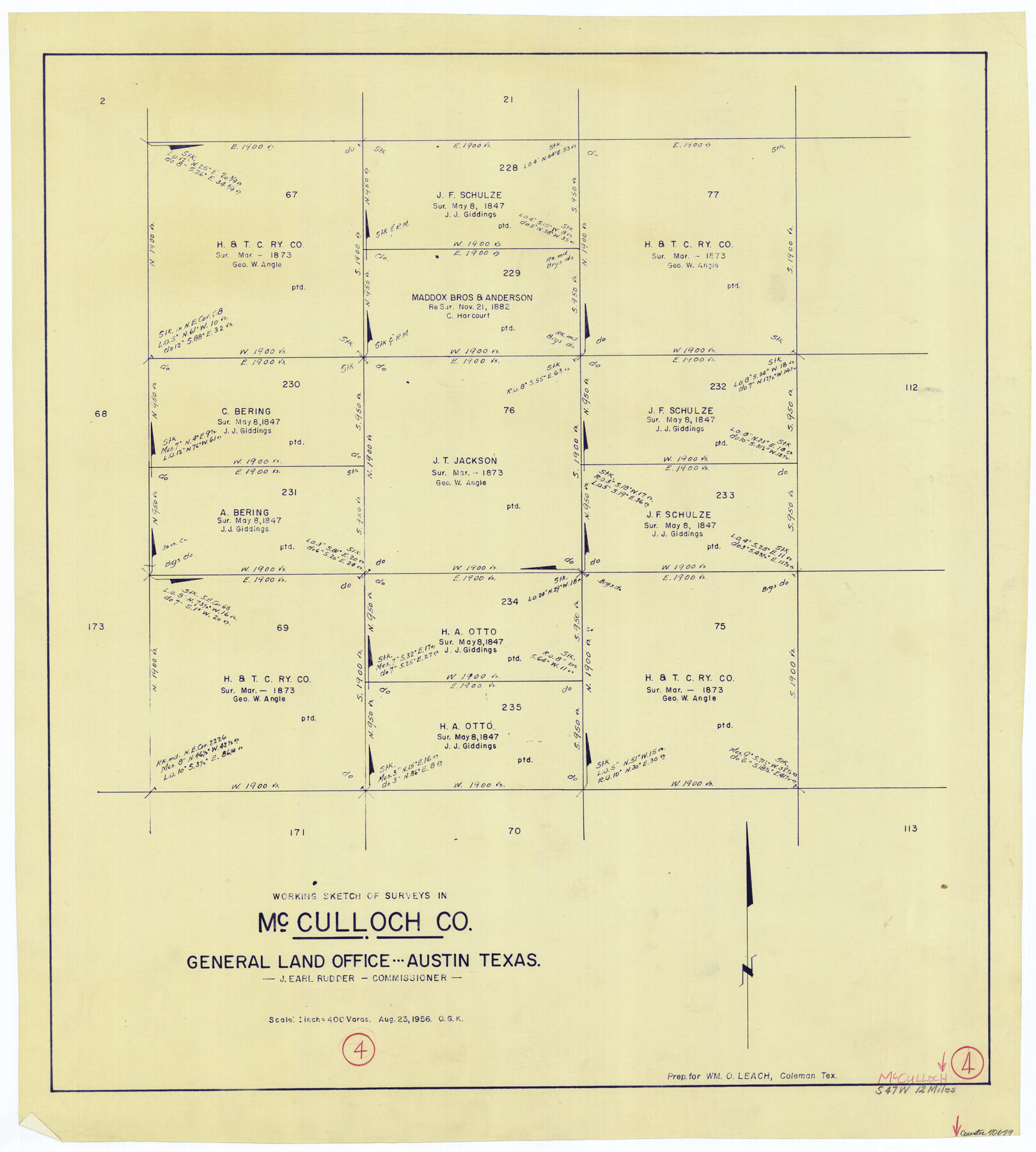
McCulloch County Working Sketch 4
-
Map/Doc
70679
-
Collection
General Map Collection
-
Object Dates
8/23/1956 (Creation Date)
-
People and Organizations
Otto G. Kurio (Draftsman)
-
Counties
McCulloch
-
Subjects
Surveying Working Sketch
-
Height x Width
25.3 x 22.8 inches
64.3 x 57.9 cm
-
Scale
1" = 400 varas
Part of: General Map Collection
Goliad County Sketch File 19

Print $10.00
- Digital $50.00
Goliad County Sketch File 19
Size 12.9 x 8.0 inches
Map/Doc 24260
Llano County Working Sketch 3

Print $20.00
- Digital $50.00
Llano County Working Sketch 3
1949
Size 23.6 x 24.0 inches
Map/Doc 70621
Culberson County Rolled Sketch 51

Print $20.00
- Digital $50.00
Culberson County Rolled Sketch 51
1966
Size 35.2 x 27.0 inches
Map/Doc 5670
[Surveys in the Bexar District along the Frio and Leona Rivers]
![136, [Surveys in the Bexar District along the Frio and Leona Rivers], General Map Collection](https://historictexasmaps.com/wmedia_w700/maps/136.tif.jpg)
Print $20.00
- Digital $50.00
[Surveys in the Bexar District along the Frio and Leona Rivers]
1842
Size 16.2 x 12.2 inches
Map/Doc 136
Clay County Sketch File 22

Print $6.00
- Digital $50.00
Clay County Sketch File 22
Size 12.8 x 8.3 inches
Map/Doc 18436
Hudspeth County Working Sketch 5

Print $20.00
- Digital $50.00
Hudspeth County Working Sketch 5
1921
Size 27.8 x 38.8 inches
Map/Doc 66286
McClennan County Robertson District East of the Brazos Milam District West of the Brazos

Print $20.00
- Digital $50.00
McClennan County Robertson District East of the Brazos Milam District West of the Brazos
1878
Size 21.0 x 23.4 inches
Map/Doc 3865

Bowie County Working Sketch 20

Print $20.00
- Digital $50.00
Bowie County Working Sketch 20
1965
Size 33.0 x 31.9 inches
Map/Doc 67424
Coke County Rolled Sketch 14

Print $20.00
- Digital $50.00
Coke County Rolled Sketch 14
Size 26.8 x 18.9 inches
Map/Doc 5514
Flight Mission No. CRC-2R, Frame 200, Chambers County

Print $20.00
- Digital $50.00
Flight Mission No. CRC-2R, Frame 200, Chambers County
1956
Size 18.8 x 22.4 inches
Map/Doc 84778
DeWitt County Working Sketch 2a

Print $20.00
- Digital $50.00
DeWitt County Working Sketch 2a
1940
Size 25.2 x 29.8 inches
Map/Doc 68592
You may also like
Eastland County Working Sketch 34

Print $20.00
- Digital $50.00
Eastland County Working Sketch 34
1960
Size 30.8 x 28.6 inches
Map/Doc 68815
FT. W. & R. G. Ry. Right of Way Map, Whiteland to Lightner, Concho County, Texas

Print $40.00
- Digital $50.00
FT. W. & R. G. Ry. Right of Way Map, Whiteland to Lightner, Concho County, Texas
1918
Size 37.5 x 68.4 inches
Map/Doc 61413

McMullen County

Print $20.00
- Digital $50.00
McMullen County
1889
Size 12.4 x 16.4 inches
Map/Doc 92957
Red River, Levee Improvement Districts Widths of Floodways - Bois D'Arc Creek

Print $20.00
- Digital $50.00
Red River, Levee Improvement Districts Widths of Floodways - Bois D'Arc Creek
1921
Size 29.5 x 26.0 inches
Map/Doc 65271
Flight Mission No. CRC-6R, Frame 12, Chambers County

Print $20.00
- Digital $50.00
Flight Mission No. CRC-6R, Frame 12, Chambers County
1956
Size 18.7 x 22.3 inches
Map/Doc 84966
[Map showing T&P Lands in El Paso County]
![88938, [Map showing T&P Lands in El Paso County], Library of Congress](https://historictexasmaps.com/wmedia_w700/maps/88938.tif.jpg)
Print $20.00
[Map showing T&P Lands in El Paso County]
Size 22.4 x 17.2 inches
Map/Doc 88938
[T. & P. Blocks 33 and 34, Townships 4N and 5N]
![90625, [T. & P. Blocks 33 and 34, Townships 4N and 5N], Twichell Survey Records](https://historictexasmaps.com/wmedia_w700/maps/90625-1.tif.jpg)
Print $20.00
- Digital $50.00
[T. & P. Blocks 33 and 34, Townships 4N and 5N]
Size 14.4 x 17.7 inches
Map/Doc 90625
Dallas County Working Sketch 4

Print $20.00
- Digital $50.00
Dallas County Working Sketch 4
1935
Size 24.1 x 30.4 inches
Map/Doc 68570
Hill County Boundary File 1

Print $20.00
- Digital $50.00
Hill County Boundary File 1
Size 12.8 x 8.3 inches
Map/Doc 54722
Terrell County Sketch File 7

Print $20.00
- Digital $50.00
Terrell County Sketch File 7
1890
Size 13.1 x 16.2 inches
Map/Doc 12418
Smith County Working Sketch 6

Print $20.00
- Digital $50.00
Smith County Working Sketch 6
1940
Size 15.7 x 25.7 inches
Map/Doc 63891