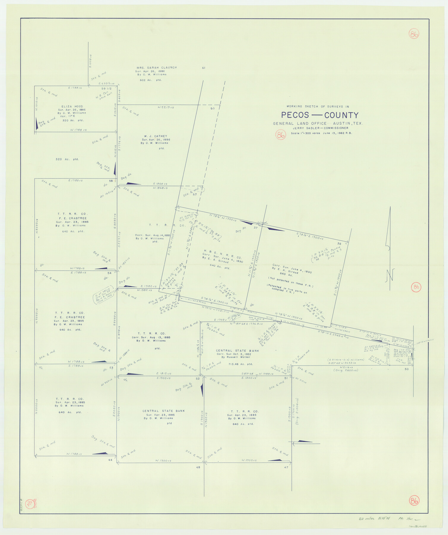
Pecos County Working Sketch 86
-
Map/Doc
71558
-
Collection
General Map Collection
-
Object Dates
6/13/1962 (Creation Date)
-
People and Organizations
Roy Buckholts (Draftsman)
-
Counties
Pecos
-
Subjects
Surveying Working Sketch
-
Height x Width
39.0 x 32.7 inches
99.1 x 83.1 cm
-
Scale
1" = 300 varas
Part of: General Map Collection
Flight Mission No. DQN-1K, Frame 32, Calhoun County

Print $20.00
- Digital $50.00
Flight Mission No. DQN-1K, Frame 32, Calhoun County
1953
Size 18.6 x 22.2 inches
Map/Doc 84137
Bandera County Sketch File 22

Print $4.00
- Digital $50.00
Bandera County Sketch File 22
Size 12.6 x 7.9 inches
Map/Doc 14012
McLennan County Sketch File 16

Print $4.00
- Digital $50.00
McLennan County Sketch File 16
1873
Size 12.7 x 8.2 inches
Map/Doc 31276
Map of Brown County

Print $20.00
- Digital $50.00
Map of Brown County
Size 25.4 x 23.5 inches
Map/Doc 3340
Aransas County Rolled Sketch 16

Print $40.00
- Digital $50.00
Aransas County Rolled Sketch 16
1965
Size 44.1 x 92.5 inches
Map/Doc 8412
[Surveys along the San Antonio and Cibolo Rivers]
![69, [Surveys along the San Antonio and Cibolo Rivers], General Map Collection](https://historictexasmaps.com/wmedia_w700/maps/69.tif.jpg)
Print $20.00
- Digital $50.00
[Surveys along the San Antonio and Cibolo Rivers]
Size 16.9 x 20.2 inches
Map/Doc 69
[Map of the Stockdale-Cuero Extension G.H. & S.A. Ry.]
![64096, [Map of the Stockdale-Cuero Extension G.H. & S.A. Ry.], General Map Collection](https://historictexasmaps.com/wmedia_w700/maps/64096.tif.jpg)
Print $40.00
- Digital $50.00
[Map of the Stockdale-Cuero Extension G.H. & S.A. Ry.]
1905
Size 19.4 x 118.2 inches
Map/Doc 64096
Tarrant County Sketch File 17

Print $8.00
- Digital $50.00
Tarrant County Sketch File 17
1860
Size 8.3 x 8.1 inches
Map/Doc 37716
Pecos County Rolled Sketch 100

Print $20.00
- Digital $50.00
Pecos County Rolled Sketch 100
1936
Size 45.2 x 25.2 inches
Map/Doc 9712
San Patricio County Rolled Sketch 38A

Print $20.00
- Digital $50.00
San Patricio County Rolled Sketch 38A
1958
Size 26.6 x 23.5 inches
Map/Doc 7589
Liberty County Rolled Sketch F

Print $20.00
- Digital $50.00
Liberty County Rolled Sketch F
Size 24.9 x 25.5 inches
Map/Doc 6621
Kimble County Working Sketch 22

Print $20.00
- Digital $50.00
Kimble County Working Sketch 22
1929
Size 25.2 x 21.1 inches
Map/Doc 70090
You may also like
Cameron County Rolled Sketch 19

Print $20.00
- Digital $50.00
Cameron County Rolled Sketch 19
1937
Size 26.0 x 21.8 inches
Map/Doc 5470
Uvalde County Sketch File 32

Print $12.00
- Digital $50.00
Uvalde County Sketch File 32
2008
Size 8.5 x 11.0 inches
Map/Doc 89025
![90260, [League 271], Twichell Survey Records](https://historictexasmaps.com/wmedia_w700/maps/90260-1.tif.jpg)
Leon County Working Sketch 47

Print $20.00
- Digital $50.00
Leon County Working Sketch 47
1980
Size 29.3 x 25.8 inches
Map/Doc 70446
Van Zandt County Sketch File 15b

Print $4.00
- Digital $50.00
Van Zandt County Sketch File 15b
1858
Size 12.2 x 7.7 inches
Map/Doc 39408
Railroad and County Map of Texas

Print $20.00
- Digital $50.00
Railroad and County Map of Texas
1887
Size 18.0 x 23.9 inches
Map/Doc 93959
Eastland County Working Sketch 29

Print $20.00
- Digital $50.00
Eastland County Working Sketch 29
1952
Size 21.1 x 22.3 inches
Map/Doc 68810
Chambers County Working Sketch 4

Print $20.00
- Digital $50.00
Chambers County Working Sketch 4
1937
Size 34.0 x 31.4 inches
Map/Doc 67987
Starr County Sketch File 50

Print $40.00
- Digital $50.00
Starr County Sketch File 50
1963
Size 12.4 x 15.5 inches
Map/Doc 37007
Intracoastal Waterway in Texas - Corpus Christi to Point Isabel including Arroyo Colorado to Mo. Pac. R.R. Bridge Near Harlingen

Print $20.00
- Digital $50.00
Intracoastal Waterway in Texas - Corpus Christi to Point Isabel including Arroyo Colorado to Mo. Pac. R.R. Bridge Near Harlingen
1933
Size 28.0 x 41.2 inches
Map/Doc 61872
Surveys made on the San Miguel. March 1847

Print $2.00
- Digital $50.00
Surveys made on the San Miguel. March 1847
1847
Size 10.4 x 8.4 inches
Map/Doc 223
Real County Rolled Sketch 11

Print $20.00
- Digital $50.00
Real County Rolled Sketch 11
Size 31.4 x 36.5 inches
Map/Doc 7458