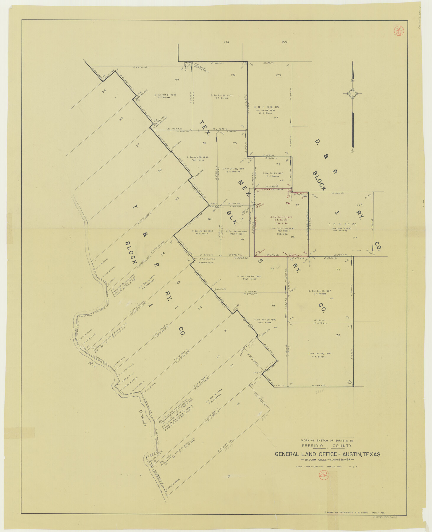
Presidio County Working Sketch 29a
-
Map/Doc
71706
-
Collection
General Map Collection
-
Object Dates
3/27/1946 (Creation Date)
-
People and Organizations
Otto G. Kurio (Draftsman)
-
Counties
Presidio
-
Subjects
Surveying Working Sketch
-
Height x Width
38.9 x 31.6 inches
98.8 x 80.3 cm
-
Scale
1" = 400 varas
Part of: General Map Collection
Flight Mission No. DIX-10P, Frame 182, Aransas County

Print $20.00
- Digital $50.00
Flight Mission No. DIX-10P, Frame 182, Aransas County
1956
Size 18.6 x 22.3 inches
Map/Doc 83972
Railroad Track Map, H&TCRRCo., Falls County, Texas

Print $4.00
- Digital $50.00
Railroad Track Map, H&TCRRCo., Falls County, Texas
1918
Size 11.6 x 18.6 inches
Map/Doc 62852
San Antonio Bay and Vicinity in Aransas and Calhoun Counties, showing Subdivsion for Mineral Development

Print $40.00
- Digital $50.00
San Antonio Bay and Vicinity in Aransas and Calhoun Counties, showing Subdivsion for Mineral Development
1948
Size 37.0 x 74.5 inches
Map/Doc 1912
Terrell County Working Sketch 10

Print $20.00
- Digital $50.00
Terrell County Working Sketch 10
1924
Size 28.0 x 25.9 inches
Map/Doc 62159
Current Miscellaneous File 34

Print $10.00
- Digital $50.00
Current Miscellaneous File 34
1953
Size 14.1 x 8.7 inches
Map/Doc 73942
Motley County Sketch File 6 (S)

Print $22.00
- Digital $50.00
Motley County Sketch File 6 (S)
Size 12.9 x 13.8 inches
Map/Doc 32145
Galveston Bay Texas Lower Part Encluding [sic] Bar and Entrance
![69869, Galveston Bay Texas Lower Part Encluding [sic] Bar and Entrance, General Map Collection](https://historictexasmaps.com/wmedia_w700/maps/69869-1.tif.jpg)
Print $40.00
- Digital $50.00
Galveston Bay Texas Lower Part Encluding [sic] Bar and Entrance
1867
Size 52.6 x 39.1 inches
Map/Doc 69869
[Surveys in Power and Hewetson's Colony]
![2, [Surveys in Power and Hewetson's Colony], General Map Collection](https://historictexasmaps.com/wmedia_w700/maps/2.tif.jpg)
Print $20.00
- Digital $50.00
[Surveys in Power and Hewetson's Colony]
1830
Size 21.3 x 22.5 inches
Map/Doc 2
Shelby County Sketch File 1

Print $4.00
- Digital $50.00
Shelby County Sketch File 1
1848
Size 12.6 x 8.0 inches
Map/Doc 36591
Galveston County Rolled Sketch Z63

Print $20.00
- Digital $50.00
Galveston County Rolled Sketch Z63
1935
Size 34.6 x 22.5 inches
Map/Doc 5995
Schleicher County Rolled Sketch 10

Print $20.00
- Digital $50.00
Schleicher County Rolled Sketch 10
Size 28.9 x 29.1 inches
Map/Doc 7752
Map of McCulloch County

Print $20.00
- Digital $50.00
Map of McCulloch County
1858
Size 26.6 x 22.4 inches
Map/Doc 3855
You may also like
Wise County Sketch File 31

Print $12.00
- Digital $50.00
Wise County Sketch File 31
1877
Size 13.1 x 8.1 inches
Map/Doc 40582
[PSL Blocks A6-A12]
![89780, [PSL Blocks A6-A12], Twichell Survey Records](https://historictexasmaps.com/wmedia_w700/maps/89780-1.tif.jpg)
Print $40.00
- Digital $50.00
[PSL Blocks A6-A12]
Size 23.2 x 64.7 inches
Map/Doc 89780
Controlled Mosaic by Jack Amman Photogrammetric Engineers, Inc - Sheet 55

Print $20.00
- Digital $50.00
Controlled Mosaic by Jack Amman Photogrammetric Engineers, Inc - Sheet 55
1954
Size 20.0 x 24.0 inches
Map/Doc 83514
Liberty County Sketch File 33

Print $4.00
- Digital $50.00
Liberty County Sketch File 33
Size 10.7 x 7.8 inches
Map/Doc 29967
Galveston County Sketch File 17

Print $2.00
- Digital $50.00
Galveston County Sketch File 17
1893
Size 10.5 x 8.9 inches
Map/Doc 23387
Schleicher County Working Sketch 1

Print $20.00
- Digital $50.00
Schleicher County Working Sketch 1
1902
Size 14.8 x 17.4 inches
Map/Doc 63803
Louisiana and Texas Intracoastal Waterway

Print $20.00
- Digital $50.00
Louisiana and Texas Intracoastal Waterway
1929
Size 13.8 x 19.9 inches
Map/Doc 83341
Copy of Surveyor's Field Book, Morris Browning - In Blocks 7, 5 & 4, I&GNRRCo., Hutchinson and Carson Counties, Texas

Print $2.00
- Digital $50.00
Copy of Surveyor's Field Book, Morris Browning - In Blocks 7, 5 & 4, I&GNRRCo., Hutchinson and Carson Counties, Texas
1888
Size 7.0 x 8.8 inches
Map/Doc 62267
Uvalde County Working Sketch 12

Print $20.00
- Digital $50.00
Uvalde County Working Sketch 12
1943
Size 28.5 x 27.4 inches
Map/Doc 72082
Clason's Guide Map of Texas

Print $20.00
- Digital $50.00
Clason's Guide Map of Texas
1919
Size 22.4 x 24.5 inches
Map/Doc 97157
From Citizens of Victoria County to Redefine the Boundary Between Jackson and Victoria Counties, November 25, 1841

Print $20.00
From Citizens of Victoria County to Redefine the Boundary Between Jackson and Victoria Counties, November 25, 1841
2020
Size 23.3 x 21.7 inches
Map/Doc 96394
Flight Mission No. DIX-8P, Frame 64, Aransas County

Print $20.00
- Digital $50.00
Flight Mission No. DIX-8P, Frame 64, Aransas County
1956
Size 18.7 x 22.4 inches
Map/Doc 83895