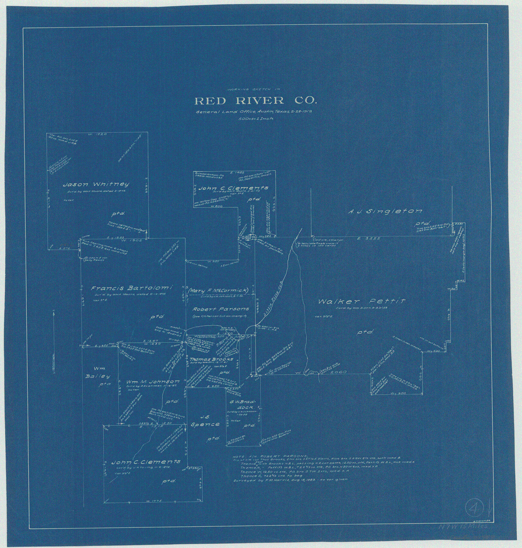
Red River County Working Sketch 4
-
Map/Doc
71987
-
Collection
General Map Collection
-
Object Dates
2/28/1919 (Creation Date)
-
People and Organizations
G.T. Wicker (Draftsman)
-
Counties
Red River
-
Subjects
Surveying Working Sketch
-
Height x Width
19.7 x 18.8 inches
50.0 x 47.8 cm
-
Scale
1" = 500 varas
Part of: General Map Collection
Dimmit County Working Sketch 25

Print $20.00
- Digital $50.00
Dimmit County Working Sketch 25
1955
Size 24.9 x 18.3 inches
Map/Doc 68686
Upton County Rolled Sketch 10

Print $20.00
- Digital $50.00
Upton County Rolled Sketch 10
1911
Size 41.2 x 43.0 inches
Map/Doc 10035
Wichita County Sketch File 17

Print $20.00
- Digital $50.00
Wichita County Sketch File 17
1889
Size 29.7 x 22.4 inches
Map/Doc 12680
Baylor County Rolled Sketch 8

Print $20.00
- Digital $50.00
Baylor County Rolled Sketch 8
1883
Size 12.9 x 18.4 inches
Map/Doc 5124
Dickens County Sketch File GW2

Print $8.00
- Digital $50.00
Dickens County Sketch File GW2
Size 14.4 x 9.0 inches
Map/Doc 20938


[Surveys along the Sabine River made under G.W. Smyth, Commissioner]
![89, [Surveys along the Sabine River made under G.W. Smyth, Commissioner], General Map Collection](https://historictexasmaps.com/wmedia_w700/maps/89.tif.jpg)
Print $20.00
- Digital $50.00
[Surveys along the Sabine River made under G.W. Smyth, Commissioner]
Size 12.6 x 17.1 inches
Map/Doc 89
Dallas County Sketch File 24

Print $4.00
- Digital $50.00
Dallas County Sketch File 24
1860
Size 14.9 x 8.4 inches
Map/Doc 20459
Flight Mission No. CGI-3N, Frame 163, Cameron County

Print $20.00
- Digital $50.00
Flight Mission No. CGI-3N, Frame 163, Cameron County
1954
Size 18.5 x 22.3 inches
Map/Doc 84627
Armstrong County Sketch File 4

Print $40.00
- Digital $50.00
Armstrong County Sketch File 4
1887
Size 17.9 x 20.1 inches
Map/Doc 10840
Lavaca County Working Sketch 19

Print $20.00
- Digital $50.00
Lavaca County Working Sketch 19
1980
Size 26.9 x 29.6 inches
Map/Doc 70372
You may also like
Kenedy County Boundary File 2

Print $22.00
- Digital $50.00
Kenedy County Boundary File 2
Size 11.2 x 8.6 inches
Map/Doc 55782
[Block XO3, Parts of Blocks Y2 and 1, and vicinity]
![91182, [Block XO3, Parts of Blocks Y2 and 1, and vicinity], Twichell Survey Records](https://historictexasmaps.com/wmedia_w700/maps/91182-1.tif.jpg)
Print $20.00
- Digital $50.00
[Block XO3, Parts of Blocks Y2 and 1, and vicinity]
Size 13.1 x 13.9 inches
Map/Doc 91182
Map of Public Land on Mustang Island

Print $20.00
- Digital $50.00
Map of Public Land on Mustang Island
Size 21.9 x 17.5 inches
Map/Doc 82315
Flight Mission No. BRA-16M, Frame 180, Jefferson County

Print $20.00
- Digital $50.00
Flight Mission No. BRA-16M, Frame 180, Jefferson County
1953
Size 18.5 x 22.4 inches
Map/Doc 85778
Nacogdoches County Working Sketch 8

Print $20.00
- Digital $50.00
Nacogdoches County Working Sketch 8
1964
Size 28.0 x 22.7 inches
Map/Doc 71224
Henderson County Working Sketch 21

Print $20.00
- Digital $50.00
Henderson County Working Sketch 21
1948
Size 17.1 x 16.2 inches
Map/Doc 66154

Bandera County Sketch File 22

Print $4.00
- Digital $50.00
Bandera County Sketch File 22
Size 12.6 x 7.9 inches
Map/Doc 14012
Edwards County Rolled Sketch 37

Print $20.00
- Digital $50.00
Edwards County Rolled Sketch 37
2018
Size 23.3 x 30.2 inches
Map/Doc 94459
Jeff Davis County Working Sketch 29

Print $20.00
- Digital $50.00
Jeff Davis County Working Sketch 29
1967
Size 25.8 x 41.6 inches
Map/Doc 66524
[Surveys in Austin's Colony at Carancahua Bay]
![172, [Surveys in Austin's Colony at Carancahua Bay], General Map Collection](https://historictexasmaps.com/wmedia_w700/maps/172.tif.jpg)
Print $20.00
- Digital $50.00
[Surveys in Austin's Colony at Carancahua Bay]
Size 22.5 x 17.4 inches
Map/Doc 172
Winkler County

Print $20.00
- Digital $50.00
Winkler County
1932
Size 39.7 x 38.5 inches
Map/Doc 95678