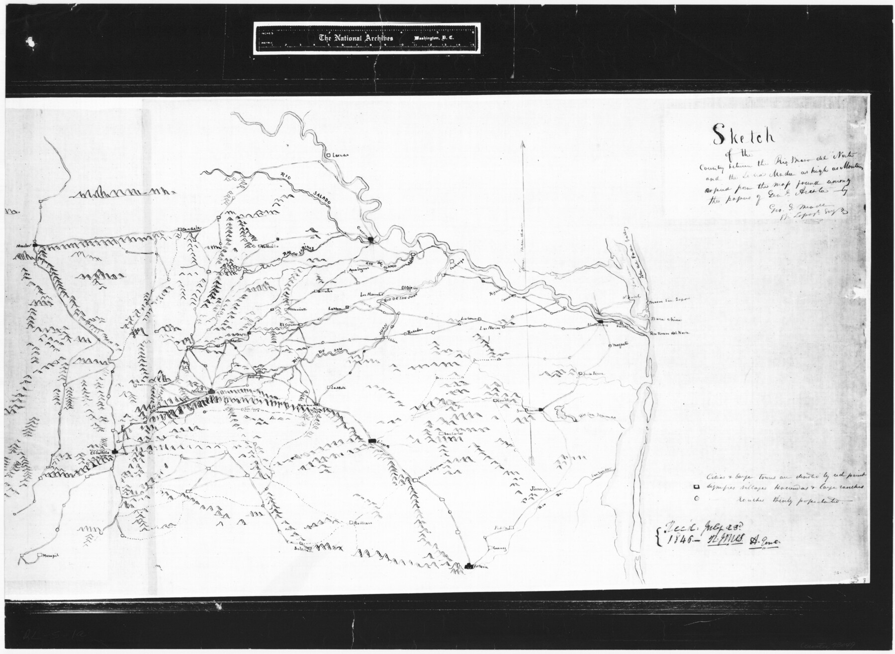
Sketch of the country between the Rio Bravo del Norte and the Luna Madre as high as Monterey copied from the map found among the papers of Genl. Arista
RL-5-1a
-
Map/Doc
73049
-
Collection
General Map Collection
-
Object Dates
1846 (Creation Date)
-
People and Organizations
George G. Meade (Draftsman)
-
Subjects
Military
-
Height x Width
18.2 x 24.9 inches
46.2 x 63.2 cm
-
Comments
B/W photostat copy from National Archives in multiple pieces.
Part of: General Map Collection
Brazoria County Working Sketch 14

Print $20.00
- Digital $50.00
Brazoria County Working Sketch 14
1940
Size 33.6 x 43.9 inches
Map/Doc 67499
Supreme Court of the United States, October Term, 1923, No. 15, Original - The State of Oklahoma, Complainant vs. The State of Texas, Defendant, The United States, Intervener; Report of the Boundary Commissioners

Print $20.00
- Digital $50.00
Supreme Court of the United States, October Term, 1923, No. 15, Original - The State of Oklahoma, Complainant vs. The State of Texas, Defendant, The United States, Intervener; Report of the Boundary Commissioners
1923
Size 33.9 x 36.8 inches
Map/Doc 75134
Jasper County Working Sketch 5

Print $20.00
- Digital $50.00
Jasper County Working Sketch 5
1906
Size 26.8 x 38.0 inches
Map/Doc 66467

Marion County Working Sketch 29

Print $20.00
- Digital $50.00
Marion County Working Sketch 29
1977
Size 20.4 x 16.1 inches
Map/Doc 70805
Schleicher County Sketch File 14

Print $12.00
- Digital $50.00
Schleicher County Sketch File 14
1917
Size 12.9 x 8.3 inches
Map/Doc 36498
Atascosa County Working Sketch 35

Print $20.00
- Digital $50.00
Atascosa County Working Sketch 35
1992
Size 34.6 x 48.1 inches
Map/Doc 67231
Webb County Working Sketch 93

Print $20.00
- Digital $50.00
Webb County Working Sketch 93
1989
Size 15.7 x 20.1 inches
Map/Doc 72460
Karnes County Working Sketch 7

Print $20.00
- Digital $50.00
Karnes County Working Sketch 7
1961
Size 20.8 x 24.2 inches
Map/Doc 66655
Flight Mission No. DQO-11K, Frame 18, Galveston County

Print $20.00
- Digital $50.00
Flight Mission No. DQO-11K, Frame 18, Galveston County
1952
Size 18.7 x 22.4 inches
Map/Doc 85211
Presidio County Working Sketch 24

Print $20.00
- Digital $50.00
Presidio County Working Sketch 24
1945
Size 18.0 x 11.9 inches
Map/Doc 71700
Angelina County Sketch File 11

Print $10.00
- Digital $50.00
Angelina County Sketch File 11
1859
Size 12.4 x 8.3 inches
Map/Doc 12937
You may also like
Map of Texas from the most recent authorities

Map of Texas from the most recent authorities
1845
Size 11.2 x 17.2 inches
Map/Doc 4333
Brazos River, Brazos River Sheet 1

Print $20.00
- Digital $50.00
Brazos River, Brazos River Sheet 1
1926
Size 20.7 x 25.3 inches
Map/Doc 69665
Williamson County Sketch File 5a

Print $4.00
- Digital $50.00
Williamson County Sketch File 5a
1849
Size 12.8 x 8.1 inches
Map/Doc 40312
Caldwell County Rolled Sketch 1

Print $20.00
- Digital $50.00
Caldwell County Rolled Sketch 1
1953
Size 20.2 x 30.4 inches
Map/Doc 10673
Flight Mission No. DQO-6K, Frame 21, Galveston County

Print $20.00
- Digital $50.00
Flight Mission No. DQO-6K, Frame 21, Galveston County
1952
Size 18.7 x 22.3 inches
Map/Doc 85094
Floyd County Working Sketch 2

Print $20.00
- Digital $50.00
Floyd County Working Sketch 2
1911
Size 41.0 x 24.8 inches
Map/Doc 69181
[Aerial photograph showing R. H. Welder Ranch, San Patricio County, Texas]
![61407, [Aerial photograph showing R. H. Welder Ranch, San Patricio County, Texas], General Map Collection](https://historictexasmaps.com/wmedia_w700/maps/61407.tif.jpg)
Print $20.00
- Digital $50.00
[Aerial photograph showing R. H. Welder Ranch, San Patricio County, Texas]
Size 23.0 x 39.5 inches
Map/Doc 61407
[Sketch of Surveys in Crockett County, Texas]
![10778, [Sketch of Surveys in Crockett County, Texas], Maddox Collection](https://historictexasmaps.com/wmedia_w700/maps/10778.tif.jpg)
Print $20.00
- Digital $50.00
[Sketch of Surveys in Crockett County, Texas]
1880
Size 12.7 x 21.3 inches
Map/Doc 10778
Travis County Sketch File 21

Print $4.00
- Digital $50.00
Travis County Sketch File 21
1875
Size 12.8 x 8.4 inches
Map/Doc 38325
Real County Working Sketch 90

Print $20.00
- Digital $50.00
Real County Working Sketch 90
1991
Size 16.7 x 22.8 inches
Map/Doc 71982

Nueces County Sketch File 80

Print $102.00
- Digital $50.00
Nueces County Sketch File 80
1997
Size 11.0 x 8.5 inches
Map/Doc 33104