Current Miscellaneous File 25
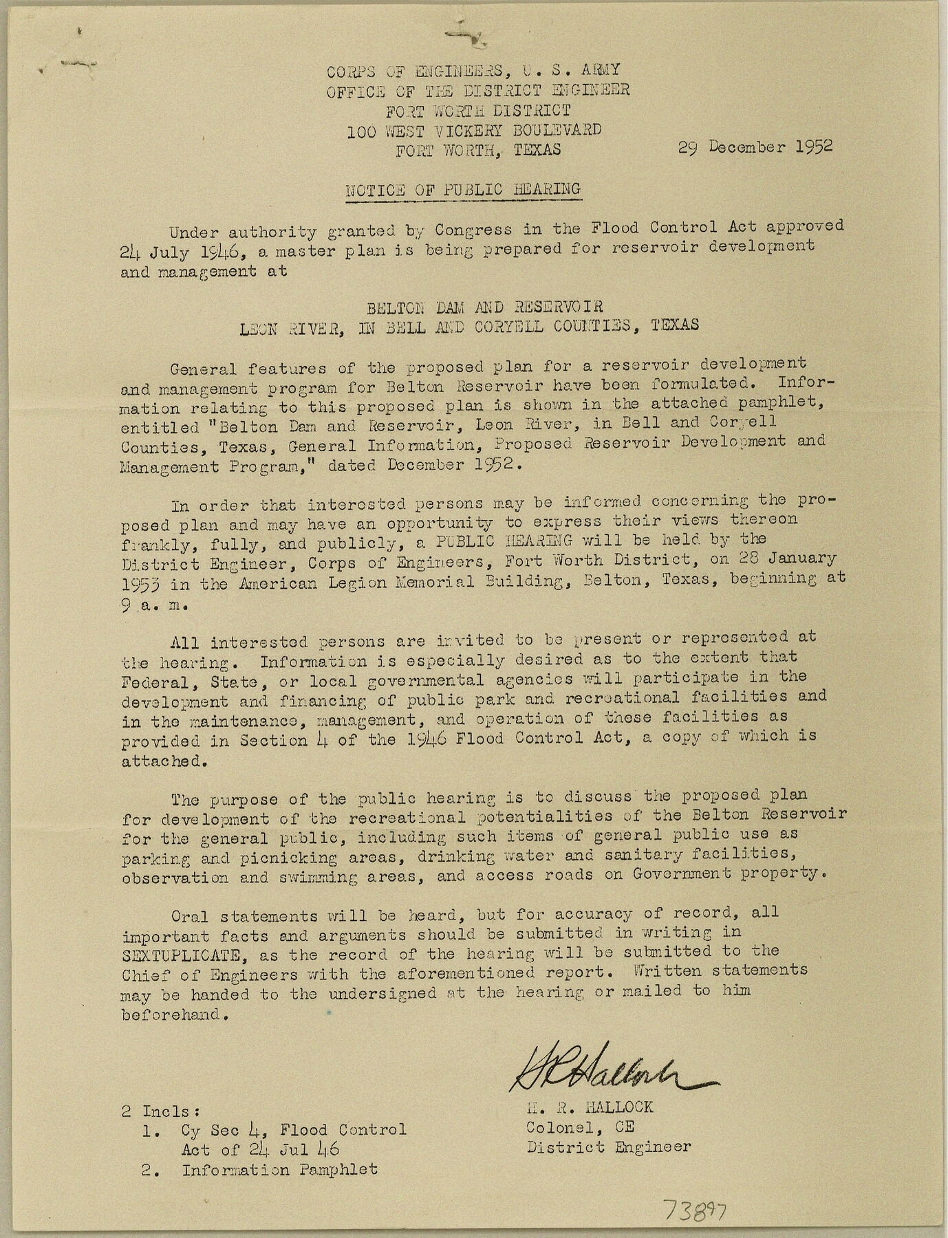
Notice of Public Hearing - Corps of Engineers, Fort Worth District. Belton Dam and Reservoirs, Leon River in Bell and Coryell Counties
-
Map/Doc
73897
-
Collection
General Map Collection
-
Object Dates
1953/1/28 (Creation Date)
-
Subjects
Curiosities
-
Height x Width
10.6 x 8.2 inches
26.9 x 20.8 cm
Part of: General Map Collection

[Sketch for Mineral Application 24072, San Jacinto River]
![65589, [Sketch for Mineral Application 24072, San Jacinto River], General Map Collection](https://historictexasmaps.com/wmedia_w700/maps/65589.tif.jpg)
Print $20.00
- Digital $50.00
[Sketch for Mineral Application 24072, San Jacinto River]
1929
Size 29.6 x 14.7 inches
Map/Doc 65589
Photo Index of Texas Coast - Sheet 5 of 6

Print $20.00
- Digital $50.00
Photo Index of Texas Coast - Sheet 5 of 6
1954
Size 20.0 x 24.0 inches
Map/Doc 83443
Dimmit County Rolled Sketch 3

Print $20.00
- Digital $50.00
Dimmit County Rolled Sketch 3
Size 31.9 x 36.2 inches
Map/Doc 76142
Rains County Working Sketch 10

Print $20.00
- Digital $50.00
Rains County Working Sketch 10
1998
Size 36.1 x 34.7 inches
Map/Doc 71836
Culberson County Rolled Sketch 46

Print $40.00
- Digital $50.00
Culberson County Rolled Sketch 46
1953
Size 53.1 x 43.1 inches
Map/Doc 8754
Briscoe County Sketch File E

Print $40.00
- Digital $50.00
Briscoe County Sketch File E
Size 26.0 x 33.7 inches
Map/Doc 11003
Jeff Davis County Sketch File 28

Print $30.00
- Digital $50.00
Jeff Davis County Sketch File 28
1916
Size 7.2 x 8.7 inches
Map/Doc 28003
Presidio County Working Sketch 43

Print $40.00
- Digital $50.00
Presidio County Working Sketch 43
1949
Size 29.0 x 54.9 inches
Map/Doc 71720
Navigation Maps of Gulf Intracoastal Waterway, Port Arthur to Brownsville, Texas

Print $4.00
- Digital $50.00
Navigation Maps of Gulf Intracoastal Waterway, Port Arthur to Brownsville, Texas
1951
Size 16.5 x 21.1 inches
Map/Doc 65435
Flight Mission No. BRA-9M, Frame 67, Jefferson County

Print $20.00
- Digital $50.00
Flight Mission No. BRA-9M, Frame 67, Jefferson County
1953
Size 18.7 x 22.4 inches
Map/Doc 85650
Angelina County Working Sketch 1

Print $20.00
- Digital $50.00
Angelina County Working Sketch 1
Size 17.3 x 17.8 inches
Map/Doc 67081
You may also like

Flight Mission No. DCL-7C, Frame 139, Kenedy County

Print $20.00
- Digital $50.00
Flight Mission No. DCL-7C, Frame 139, Kenedy County
1943
Size 18.5 x 22.3 inches
Map/Doc 86096
City of Lamesa, Texas

Print $40.00
- Digital $50.00
City of Lamesa, Texas
Size 52.2 x 43.2 inches
Map/Doc 89855
Cass County Working Sketch 1

Print $20.00
- Digital $50.00
Cass County Working Sketch 1
Size 20.2 x 21.9 inches
Map/Doc 67904
Winkler County Rolled Sketch 7

Print $20.00
- Digital $50.00
Winkler County Rolled Sketch 7
1929
Size 27.6 x 32.5 inches
Map/Doc 8273
Intracoastal Waterway in Texas - Corpus Christi to Point Isabel including Arroyo Colorado to Mo. Pac. R.R. Bridge Near Harlingen

Print $20.00
- Digital $50.00
Intracoastal Waterway in Texas - Corpus Christi to Point Isabel including Arroyo Colorado to Mo. Pac. R.R. Bridge Near Harlingen
1933
Size 27.7 x 40.8 inches
Map/Doc 61867
Jefferson County Rolled Sketch 46

Print $2.00
- Digital $50.00
Jefferson County Rolled Sketch 46
1969
Size 12.3 x 5.9 inches
Map/Doc 10198
Flight Mission No. DQN-2K, Frame 77, Calhoun County

Print $20.00
- Digital $50.00
Flight Mission No. DQN-2K, Frame 77, Calhoun County
1953
Size 16.1 x 15.9 inches
Map/Doc 84269
Gaines County Working Sketch 24

Print $20.00
- Digital $50.00
Gaines County Working Sketch 24
1983
Size 36.4 x 37.9 inches
Map/Doc 69324
Grayson County Working Sketch 17

Print $20.00
- Digital $50.00
Grayson County Working Sketch 17
1955
Size 16.0 x 42.5 inches
Map/Doc 63256
Tarrant County Working Sketch 13

Print $20.00
- Digital $50.00
Tarrant County Working Sketch 13
1987
Size 22.4 x 30.8 inches
Map/Doc 62430
Glasscock County Sketch File 28

Print $40.00
Glasscock County Sketch File 28
1877
Size 15.7 x 15.9 inches
Map/Doc 38163