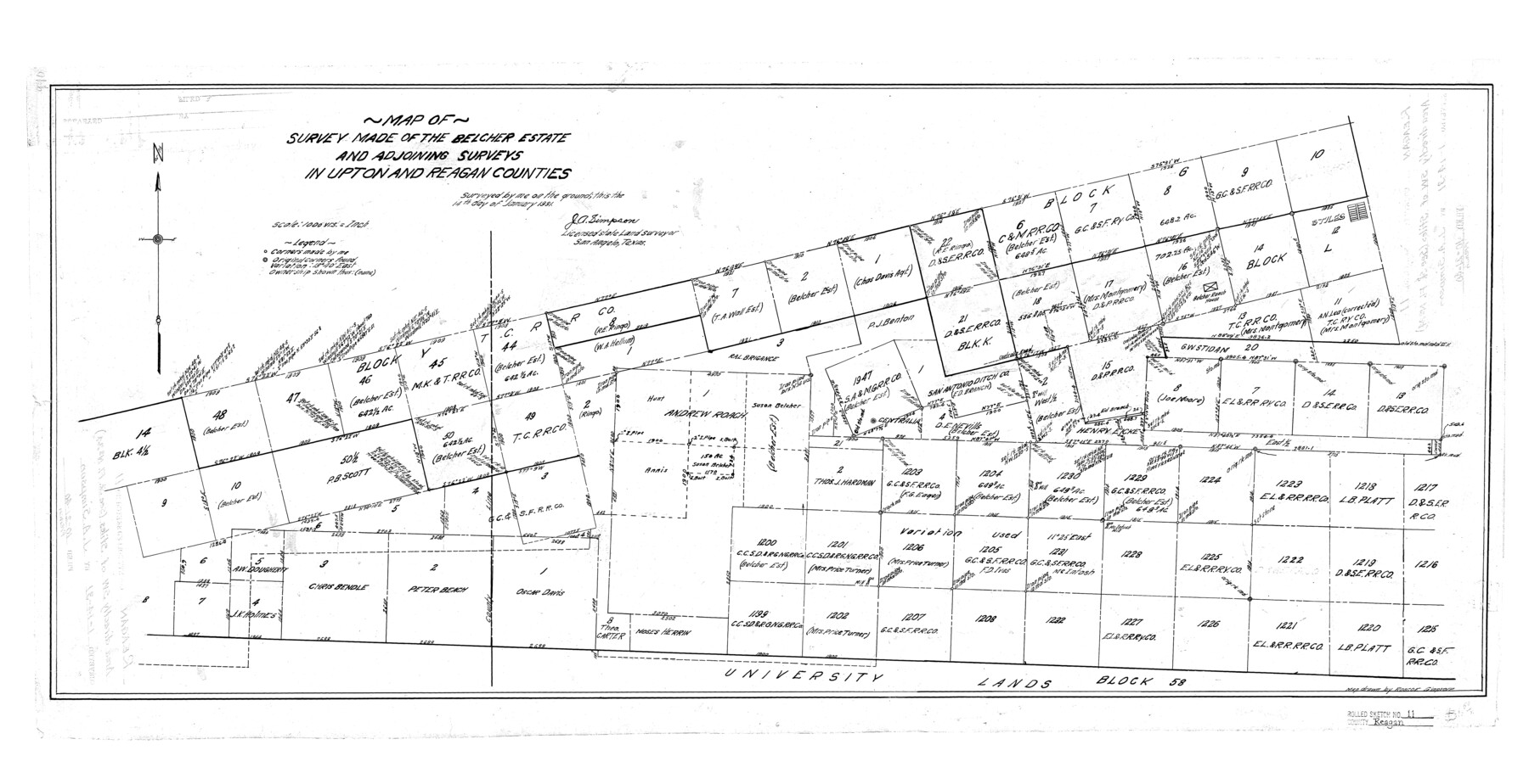
Reagan County Rolled Sketch 11
Map of survey made of the Belcher Estate and adjoining surveys in Upton and Reagan Counties
-
Map/Doc
7439
-
Collection
General Map Collection
-
Object Dates
1931/1/14 (Creation Date)
1940/10/21 (File Date)
-
People and Organizations
J.A. Simpson (Surveyor/Engineer)
Roscoe Simpson (Draftsman)
-
Counties
Reagan Upton
-
Subjects
Surveying Rolled Sketch
-
Height x Width
20.2 x 39.3 inches
51.3 x 99.8 cm
-
Scale
1" = 1000 varas
Part of: General Map Collection
Medina County Rolled Sketch 11

Print $20.00
- Digital $50.00
Medina County Rolled Sketch 11
Size 27.4 x 25.6 inches
Map/Doc 6745
International and Great Northern Railroad Lone Star Route and Connections

Print $20.00
- Digital $50.00
International and Great Northern Railroad Lone Star Route and Connections
1877
Size 17.3 x 23.2 inches
Map/Doc 93462
Johnson County Rolled Sketch B

Print $20.00
- Digital $50.00
Johnson County Rolled Sketch B
1891
Size 28.2 x 38.9 inches
Map/Doc 6449
Clay County Sketch File 39

Print $10.00
- Digital $50.00
Clay County Sketch File 39
1940
Size 14.3 x 8.7 inches
Map/Doc 18472
Coke County Sketch File 35

Print $6.00
- Digital $50.00
Coke County Sketch File 35
1967
Size 14.2 x 8.6 inches
Map/Doc 18649
Kinney County Working Sketch 4

Print $20.00
- Digital $50.00
Kinney County Working Sketch 4
1907
Size 21.1 x 21.6 inches
Map/Doc 70186
Fort Bend County State Real Property Sketch 8

Print $40.00
- Digital $50.00
Fort Bend County State Real Property Sketch 8
1985
Size 35.0 x 43.6 inches
Map/Doc 61682
Duval County Sketch File 66

Print $12.00
- Digital $50.00
Duval County Sketch File 66
1944
Size 14.5 x 8.8 inches
Map/Doc 21444
Montgomery County Rolled Sketch 32

Print $40.00
- Digital $50.00
Montgomery County Rolled Sketch 32
1949
Size 59.9 x 40.4 inches
Map/Doc 9540
Hardeman County Sketch File 26

Print $40.00
- Digital $50.00
Hardeman County Sketch File 26
Size 16.3 x 13.2 inches
Map/Doc 25037
Floyd County Sketch File 30

Print $20.00
- Digital $50.00
Floyd County Sketch File 30
Size 12.6 x 33.9 inches
Map/Doc 11489
DeWitt County Working Sketch 2a

Print $20.00
- Digital $50.00
DeWitt County Working Sketch 2a
1940
Size 25.2 x 29.8 inches
Map/Doc 68592
You may also like
Map of Archer County, Young Land District, formerly Fannin Land District

Print $20.00
- Digital $50.00
Map of Archer County, Young Land District, formerly Fannin Land District
1859
Size 25.2 x 21.6 inches
Map/Doc 3237
Hall County Sketch File 24

Print $10.00
- Digital $50.00
Hall County Sketch File 24
1911
Size 11.2 x 8.6 inches
Map/Doc 24817
[Sketch for Mineral Application 27669 - Trinity River, Frank R. Graves]
![65629, [Sketch for Mineral Application 27669 - Trinity River, Frank R. Graves], General Map Collection](https://historictexasmaps.com/wmedia_w700/maps/65629-1.tif.jpg)
Print $40.00
- Digital $50.00
[Sketch for Mineral Application 27669 - Trinity River, Frank R. Graves]
Size 28.0 x 102.2 inches
Map/Doc 65629
[North part of PSL Block A-19 and adjoining School Land Leagues]
![93024, [North part of PSL Block A-19 and adjoining School Land Leagues], Twichell Survey Records](https://historictexasmaps.com/wmedia_w700/maps/93024-1.tif.jpg)
Print $20.00
- Digital $50.00
[North part of PSL Block A-19 and adjoining School Land Leagues]
Size 23.5 x 19.1 inches
Map/Doc 93024
Erath County Working Sketch 52

Print $20.00
- Digital $50.00
Erath County Working Sketch 52
1992
Size 33.9 x 33.6 inches
Map/Doc 69134
Sketch Showing D. Rubin Surveys

Print $20.00
- Digital $50.00
Sketch Showing D. Rubin Surveys
1926
Size 35.1 x 24.5 inches
Map/Doc 91165
Kleberg County Rolled Sketch 10-35

Print $20.00
- Digital $50.00
Kleberg County Rolled Sketch 10-35
1952
Size 38.2 x 35.4 inches
Map/Doc 9366
Lavaca County Working Sketch 24

Print $20.00
- Digital $50.00
Lavaca County Working Sketch 24
1985
Size 29.5 x 35.7 inches
Map/Doc 70377
Bosque County Working Sketch 1

Print $20.00
- Digital $50.00
Bosque County Working Sketch 1
Size 16.3 x 13.7 inches
Map/Doc 67434
Kendall County Sketch File 27

Print $6.00
- Digital $50.00
Kendall County Sketch File 27
1950
Size 12.4 x 10.9 inches
Map/Doc 28731
Map of Houston Co.

Print $40.00
- Digital $50.00
Map of Houston Co.
1896
Size 48.8 x 46.8 inches
Map/Doc 76035
United States including territories and insular possessions showing the extent of public surveys, national parks, national forests, indian reservations, national wildlife refuges, and reclamation projects

Print $40.00
- Digital $50.00
United States including territories and insular possessions showing the extent of public surveys, national parks, national forests, indian reservations, national wildlife refuges, and reclamation projects
1953
Size 64.5 x 44.5 inches
Map/Doc 65795