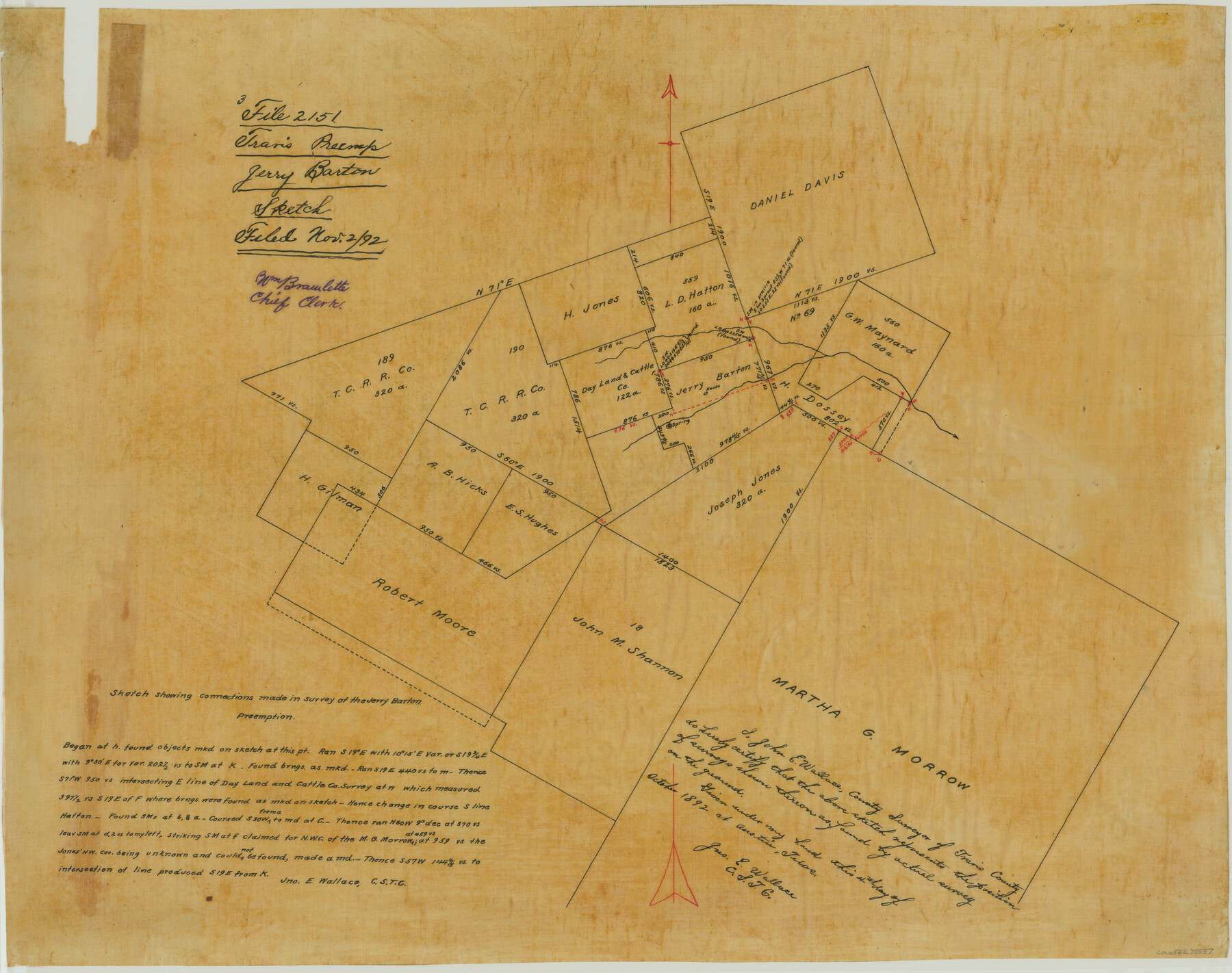
Sketch showing connections made in survey of the Jerry Barton preemption
-
Map/Doc
75557
-
Collection
Maddox Collection
-
Object Dates
1892/10/4 (Creation Date)
1892/11/2 (File Date)
-
People and Organizations
John E. Wallace (Surveyor/Engineer)
William Bramlette ()
-
Counties
Travis Williamson
-
Height x Width
18.7 x 23.6 inches
47.5 x 59.9 cm
-
Medium
paper, manuscript
-
Comments
From Travis P-2151.
Part of: Maddox Collection
Map of Tyler County, Texas

Print $20.00
- Digital $50.00
Map of Tyler County, Texas
1879
Size 28.6 x 22.8 inches
Map/Doc 720
[Surveying sketch of S. Hayford, E. T. R.R. Co., T. C. R. R. Co., et al in Travis County, Texas]
![10753, [Surveying sketch of S. Hayford, E. T. R.R. Co., T. C. R. R. Co., et al in Travis County, Texas], Maddox Collection](https://historictexasmaps.com/wmedia_w700/maps/10753.tif.jpg)
Print $20.00
- Digital $50.00
[Surveying sketch of S. Hayford, E. T. R.R. Co., T. C. R. R. Co., et al in Travis County, Texas]
Size 18.0 x 17.3 inches
Map/Doc 10753
Wendlandt's Subdivision of part of Outlot 4, Division "Z"

Print $20.00
- Digital $50.00
Wendlandt's Subdivision of part of Outlot 4, Division "Z"
1910
Size 17.9 x 13.5 inches
Map/Doc 5041
[Surveying Sketch in Tom Green County]
![75550, [Surveying Sketch in Tom Green County], Maddox Collection](https://historictexasmaps.com/wmedia_w700/maps/75550.tif.jpg)
Print $3.00
- Digital $50.00
[Surveying Sketch in Tom Green County]
Size 11.4 x 12.4 inches
Map/Doc 75550
[Surveying Sketch of L. Smith, Sidney Shepherd, Kenneth Hyman, et al in Montgomery County]
![625, [Surveying Sketch of L. Smith, Sidney Shepherd, Kenneth Hyman, et al in Montgomery County], Maddox Collection](https://historictexasmaps.com/wmedia_w700/maps/00625.tif.jpg)
Print $2.00
- Digital $50.00
[Surveying Sketch of L. Smith, Sidney Shepherd, Kenneth Hyman, et al in Montgomery County]
Size 7.3 x 10.6 inches
Map/Doc 625
Sketch from the map of Bailey Co.

Print $2.00
- Digital $50.00
Sketch from the map of Bailey Co.
Size 8.4 x 7.6 inches
Map/Doc 464
Map of Survey 7, Block 1, D.B. Gardner

Print $20.00
- Digital $50.00
Map of Survey 7, Block 1, D.B. Gardner
1915
Size 16.9 x 22.3 inches
Map/Doc 5067
Bosque County, Texas

Print $20.00
- Digital $50.00
Bosque County, Texas
1879
Size 25.1 x 29.9 inches
Map/Doc 420
Sketch of Menard Co.

Print $20.00
- Digital $50.00
Sketch of Menard Co.
1883
Size 15.1 x 14.2 inches
Map/Doc 536
Austin and Surrounding Properties
.tif.jpg)
Print $20.00
- Digital $50.00
Austin and Surrounding Properties
1891
Size 42.9 x 32.1 inches
Map/Doc 421
Map of Encinal County, Texas

Print $20.00
- Digital $50.00
Map of Encinal County, Texas
1879
Size 22.7 x 28.4 inches
Map/Doc 715
Austin, Texas Congress Ave. Drainage

Print $20.00
- Digital $50.00
Austin, Texas Congress Ave. Drainage
1903
Size 15.1 x 15.5 inches
Map/Doc 75797
You may also like
Flight Mission No. DQN-1K, Frame 70, Calhoun County

Print $20.00
- Digital $50.00
Flight Mission No. DQN-1K, Frame 70, Calhoun County
1953
Size 18.6 x 22.3 inches
Map/Doc 84157
Jefferson County Working Sketch 14

Print $20.00
- Digital $50.00
Jefferson County Working Sketch 14
1948
Size 30.3 x 25.8 inches
Map/Doc 66557
Fort Bend County Sketch File 32

Print $6.00
- Digital $50.00
Fort Bend County Sketch File 32
1957
Size 14.2 x 8.7 inches
Map/Doc 23002
King County Working Sketch 6

Print $20.00
- Digital $50.00
King County Working Sketch 6
1944
Size 11.5 x 18.3 inches
Map/Doc 70170
Wichita County Sketch File 9

Print $4.00
- Digital $50.00
Wichita County Sketch File 9
1878
Size 12.8 x 8.2 inches
Map/Doc 40050
Terry County Rolled Sketch 5

Print $40.00
- Digital $50.00
Terry County Rolled Sketch 5
Size 56.8 x 38.1 inches
Map/Doc 9995
Liberty County Sketch File M

Print $20.00
- Digital $50.00
Liberty County Sketch File M
1879
Size 16.9 x 14.5 inches
Map/Doc 12000
Leon County Rolled Sketch 12

Print $20.00
- Digital $50.00
Leon County Rolled Sketch 12
1974
Size 46.5 x 40.7 inches
Map/Doc 9431
Ochiltree County

Print $20.00
- Digital $50.00
Ochiltree County
1878
Size 19.2 x 17.5 inches
Map/Doc 3924
The Chief Justice County of Matagorda. Lands in Conflict with Brazoria County

Print $20.00
The Chief Justice County of Matagorda. Lands in Conflict with Brazoria County
2020
Size 19.7 x 21.7 inches
Map/Doc 96058
El Paso County Working Sketch 22

Print $20.00
- Digital $50.00
El Paso County Working Sketch 22
1961
Size 21.6 x 20.0 inches
Map/Doc 69044
[Movements & Objectives of the 143rd & 144th Infantry and many other divisions and regiments, 1918] - Verso
![94139, [Movements & Objectives of the 143rd & 144th Infantry and many other divisions and regiments, 1918] - Verso, Non-GLO Digital Images](https://historictexasmaps.com/wmedia_w700/maps/94139-1.tif.jpg)
Print $40.00
[Movements & Objectives of the 143rd & 144th Infantry and many other divisions and regiments, 1918] - Verso
1918
Size 37.2 x 63.9 inches
Map/Doc 94139