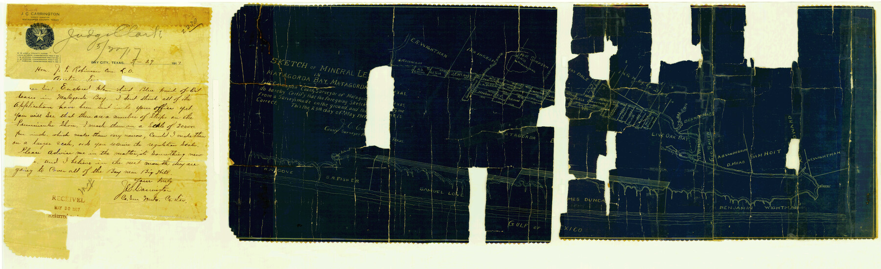
Matagorda County Rolled Sketch 13
[Sketch of oil leases in Matagorda Bay]
-
Map/Doc
7590
-
Collection
General Map Collection
-
Object Dates
5/29/1917 (Creation Date)
5/30/1917 (File Date)
-
People and Organizations
J.C. Carrington (Surveyor/Engineer)
-
Counties
Matagorda
-
Subjects
Surveying Rolled Sketch
-
Height x Width
11.3 x 37.1 inches
28.7 x 94.2 cm
-
Medium
blueprint/diazo
Part of: General Map Collection
Somervell County Working Sketch Graphic Index

Print $20.00
- Digital $50.00
Somervell County Working Sketch Graphic Index
1941
Size 27.0 x 25.7 inches
Map/Doc 76700
[Gulf, Colorado & Santa Fe]
![64575, [Gulf, Colorado & Santa Fe], General Map Collection](https://historictexasmaps.com/wmedia_w700/maps/64575.tif.jpg)
Print $40.00
- Digital $50.00
[Gulf, Colorado & Santa Fe]
Size 31.9 x 71.7 inches
Map/Doc 64575
Johnson County Sketch File 26

Print $28.00
- Digital $50.00
Johnson County Sketch File 26
1892
Size 14.3 x 8.8 inches
Map/Doc 28474
Flight Mission No. BRE-2P, Frame 124, Nueces County

Print $20.00
- Digital $50.00
Flight Mission No. BRE-2P, Frame 124, Nueces County
1956
Size 18.3 x 22.3 inches
Map/Doc 86800
Wilbarger Co.

Print $40.00
- Digital $50.00
Wilbarger Co.
1949
Size 48.2 x 39.2 inches
Map/Doc 63128
Topographical Map of the Rio Grande, Sheet No. 4

Print $20.00
- Digital $50.00
Topographical Map of the Rio Grande, Sheet No. 4
1912
Map/Doc 89528
Cooke County Sketch File 46

Print $36.00
- Digital $50.00
Cooke County Sketch File 46
2002
Size 10.5 x 8.0 inches
Map/Doc 82578

Flight Mission No. DIX-10P, Frame 64, Aransas County

Print $20.00
- Digital $50.00
Flight Mission No. DIX-10P, Frame 64, Aransas County
1956
Size 18.7 x 22.3 inches
Map/Doc 83925
Terrell County Working Sketch 36

Print $20.00
- Digital $50.00
Terrell County Working Sketch 36
1948
Size 26.8 x 39.9 inches
Map/Doc 62129
Map of Burnet County

Print $20.00
- Digital $50.00
Map of Burnet County
1876
Size 24.5 x 21.3 inches
Map/Doc 3352
Williamson County Sketch File 31

Print $14.00
- Digital $50.00
Williamson County Sketch File 31
1991
Size 11.2 x 8.4 inches
Map/Doc 40386
You may also like
Sketch of coast of Texas, Laguna Madre from Pt. of Rocks to Corpus Christi [and accompanying letter]
![72962, Sketch of coast of Texas, Laguna Madre from Pt. of Rocks to Corpus Christi [and accompanying letter], General Map Collection](https://historictexasmaps.com/wmedia_w700/maps/72962.tif.jpg)
Print $20.00
- Digital $50.00
Sketch of coast of Texas, Laguna Madre from Pt. of Rocks to Corpus Christi [and accompanying letter]
1881
Size 26.5 x 18.3 inches
Map/Doc 72962
Roberts County, State of Texas

Print $20.00
Roberts County, State of Texas
1888
Size 21.6 x 16.4 inches
Map/Doc 88990
Map Showing Relative Position of Tankersley Survey, its Subdivisions and Surrounding Surveys, Young County, Texas

Print $20.00
- Digital $50.00
Map Showing Relative Position of Tankersley Survey, its Subdivisions and Surrounding Surveys, Young County, Texas
1921
Size 22.3 x 20.3 inches
Map/Doc 92020
Carte du Texas, Extraite de la grande Carte du Mexique par A. Brué Géographe du Roi, Revue, corrigée et considerablement augmentée d'après des documens récens et renseignemens fournis par Mr. le Docteur Fc. Leclerc

Print $20.00
- Digital $50.00
Carte du Texas, Extraite de la grande Carte du Mexique par A. Brué Géographe du Roi, Revue, corrigée et considerablement augmentée d'après des documens récens et renseignemens fournis par Mr. le Docteur Fc. Leclerc
1840
Size 12.6 x 14.2 inches
Map/Doc 94273
Williamson County

Print $40.00
- Digital $50.00
Williamson County
1888
Size 39.7 x 56.3 inches
Map/Doc 63129
Gillespie County Sketch File 10

Print $4.00
- Digital $50.00
Gillespie County Sketch File 10
1877
Size 8.3 x 12.9 inches
Map/Doc 24147
Hays County Working Sketch Graphic Index

Print $20.00
- Digital $50.00
Hays County Working Sketch Graphic Index
1946
Size 43.7 x 40.9 inches
Map/Doc 76573
Hutchinson County Rolled Sketch 19

Print $20.00
- Digital $50.00
Hutchinson County Rolled Sketch 19
Size 21.3 x 25.0 inches
Map/Doc 6285
Atascosa County Rolled Sketch 23

Print $20.00
- Digital $50.00
Atascosa County Rolled Sketch 23
1940
Size 36.4 x 24.3 inches
Map/Doc 5102
[Sketch showing North line of James Stewart survey and vicinity]
![90116, [Sketch showing North line of James Stewart survey and vicinity], Twichell Survey Records](https://historictexasmaps.com/wmedia_w700/maps/90116-1.tif.jpg)
Print $20.00
- Digital $50.00
[Sketch showing North line of James Stewart survey and vicinity]
Size 30.0 x 9.0 inches
Map/Doc 90116
Brooks County Working Sketch 20

Print $20.00
- Digital $50.00
Brooks County Working Sketch 20
Size 16.5 x 21.6 inches
Map/Doc 78198
Flight Mission No. BRA-16M, Frame 97, Jefferson County

Print $20.00
- Digital $50.00
Flight Mission No. BRA-16M, Frame 97, Jefferson County
1953
Size 18.5 x 22.4 inches
Map/Doc 85709