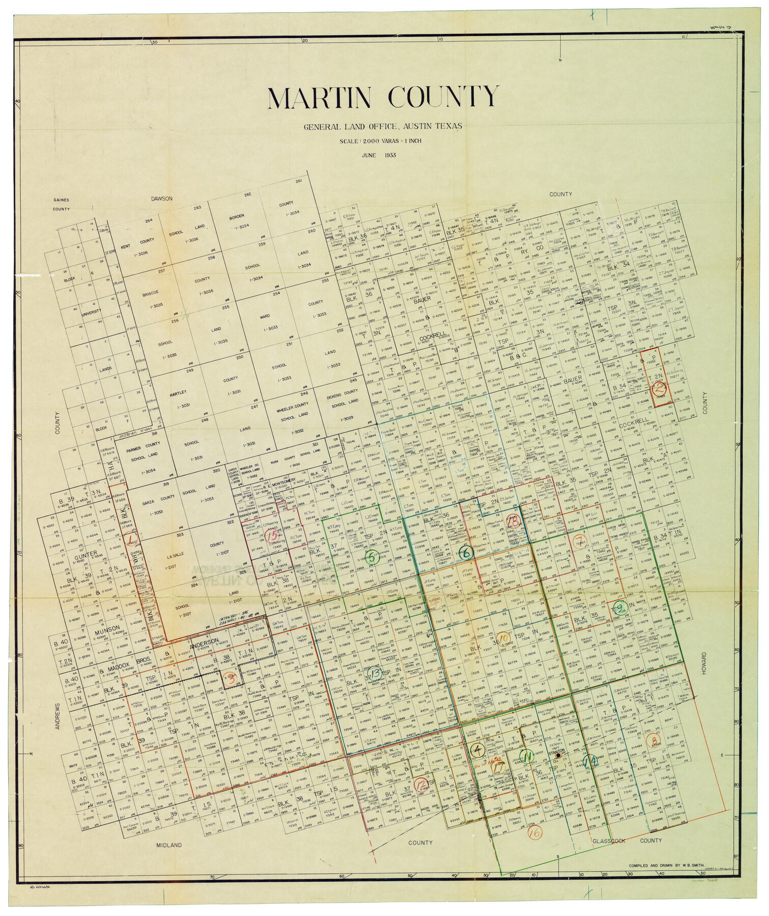
Martin County Working Sketch Graphic Index
-
Map/Doc
76631
-
Collection
General Map Collection
-
Object Dates
6/1933 (Creation Date)
-
People and Organizations
W.B. Smith (Draftsman)
-
Counties
Martin
-
Subjects
County Surveying Working Sketch
-
Height x Width
44.1 x 37.8 inches
112.0 x 96.0 cm
-
Scale
1" = 2000 varas
Part of: General Map Collection
Montague County Working Sketch 46

Print $20.00
- Digital $50.00
Montague County Working Sketch 46
2014
Size 14.7 x 20.4 inches
Map/Doc 93689
Upton County Working Sketch 40

Print $40.00
- Digital $50.00
Upton County Working Sketch 40
1959
Size 37.5 x 63.7 inches
Map/Doc 69536
Pecos County Rolled Sketch 101

Print $20.00
- Digital $50.00
Pecos County Rolled Sketch 101
1938
Size 22.5 x 39.0 inches
Map/Doc 7249
Ellis County Boundary File 4

Print $14.00
- Digital $50.00
Ellis County Boundary File 4
Size 14.2 x 8.6 inches
Map/Doc 52983
The Texas Co-Ordinate System, Title 86 Art. 5300A

Print $20.00
- Digital $50.00
The Texas Co-Ordinate System, Title 86 Art. 5300A
1943
Size 27.7 x 30.3 inches
Map/Doc 3122
Intracoastal Waterway in Texas - Corpus Christi to Point Isabel including Arroyo Colorado to Mo. Pac. R.R. Bridge Near Harlingen

Print $20.00
- Digital $50.00
Intracoastal Waterway in Texas - Corpus Christi to Point Isabel including Arroyo Colorado to Mo. Pac. R.R. Bridge Near Harlingen
1933
Size 28.2 x 40.7 inches
Map/Doc 61855
Galveston Bay Oil Area, Galveston, Harris, Chambers and Brazoria Cos.

Print $40.00
- Digital $50.00
Galveston Bay Oil Area, Galveston, Harris, Chambers and Brazoria Cos.
1927
Size 52.9 x 40.8 inches
Map/Doc 2938
Comal County Working Sketch 5

Print $20.00
- Digital $50.00
Comal County Working Sketch 5
1950
Size 19.0 x 21.4 inches
Map/Doc 68171
Newton County Working Sketch 21

Print $20.00
- Digital $50.00
Newton County Working Sketch 21
1952
Size 27.5 x 32.5 inches
Map/Doc 71267
Flight Mission No. CRC-3R, Frame 9, Chambers County

Print $20.00
- Digital $50.00
Flight Mission No. CRC-3R, Frame 9, Chambers County
1956
Size 18.7 x 22.4 inches
Map/Doc 84783
Travis County Rolled Sketch 56

Print $20.00
- Digital $50.00
Travis County Rolled Sketch 56
1885
Size 16.7 x 23.2 inches
Map/Doc 8047
Loving County Working Sketch 2

Print $20.00
- Digital $50.00
Loving County Working Sketch 2
1937
Size 33.9 x 42.5 inches
Map/Doc 70634
You may also like
Bastrop County Sketch File 3

Print $4.00
- Digital $50.00
Bastrop County Sketch File 3
1860
Size 8.9 x 9.2 inches
Map/Doc 14044
Blanco County Working Sketch Graphic Index

Print $20.00
- Digital $50.00
Blanco County Working Sketch Graphic Index
1965
Size 43.1 x 33.6 inches
Map/Doc 76467
[Northwest corner of the County]
![90873, [Northwest corner of the County], Twichell Survey Records](https://historictexasmaps.com/wmedia_w700/maps/90873-2.tif.jpg)
Print $20.00
- Digital $50.00
[Northwest corner of the County]
1903
Size 19.1 x 21.5 inches
Map/Doc 90873
[Sketch showing conflict between G. C. & S. F. Ry. Co. Block 194 and State University Blocks 16 and 17]
![91627, [Sketch showing conflict between G. C. & S. F. Ry. Co. Block 194 and State University Blocks 16 and 17], Twichell Survey Records](https://historictexasmaps.com/wmedia_w700/maps/91627-1.tif.jpg)
Print $3.00
- Digital $50.00
[Sketch showing conflict between G. C. & S. F. Ry. Co. Block 194 and State University Blocks 16 and 17]
1900
Size 11.1 x 12.1 inches
Map/Doc 91627
Bexar County Boundary File 1

Print $26.00
- Digital $50.00
Bexar County Boundary File 1
Size 14.6 x 9.1 inches
Map/Doc 50505
Victoria County Working Sketch 8

Print $20.00
- Digital $50.00
Victoria County Working Sketch 8
1957
Size 25.9 x 37.8 inches
Map/Doc 72278
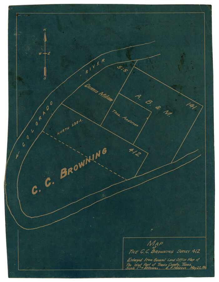
Map of the C.C. Browning survey 412 enlarged from General Land Office map of the west part of Travis County, Texas
Print $3.00
- Digital $50.00
Map of the C.C. Browning survey 412 enlarged from General Land Office map of the west part of Travis County, Texas
1920
Size 11.3 x 9.1 inches
Map/Doc 10752
Flight Mission No. BRA-16M, Frame 63, Jefferson County

Print $20.00
- Digital $50.00
Flight Mission No. BRA-16M, Frame 63, Jefferson County
1953
Size 18.6 x 22.3 inches
Map/Doc 85680
Sketch of the country between the Rio Bravo del Norte and the Luna Madre as high as Monterey copied from the map found among the papers of Genl. Arista

Print $20.00
- Digital $50.00
Sketch of the country between the Rio Bravo del Norte and the Luna Madre as high as Monterey copied from the map found among the papers of Genl. Arista
1846
Size 18.2 x 24.9 inches
Map/Doc 73049
McLennan County Working Sketch 1

Print $20.00
- Digital $50.00
McLennan County Working Sketch 1
1941
Size 21.5 x 29.6 inches
Map/Doc 70694
[Galveston, Harrisburg & San Antonio from El Paso-Presidio county boundary to Presidio-Pecos county boundary]
![64717, [Galveston, Harrisburg & San Antonio from El Paso-Presidio county boundary to Presidio-Pecos county boundary], General Map Collection](https://historictexasmaps.com/wmedia_w700/maps/64717.tif.jpg)
Print $40.00
- Digital $50.00
[Galveston, Harrisburg & San Antonio from El Paso-Presidio county boundary to Presidio-Pecos county boundary]
Size 149.3 x 44.4 inches
Map/Doc 64717
![91538, [Block 3T], Twichell Survey Records](https://historictexasmaps.com/wmedia_w700/maps/91538-1.tif.jpg)