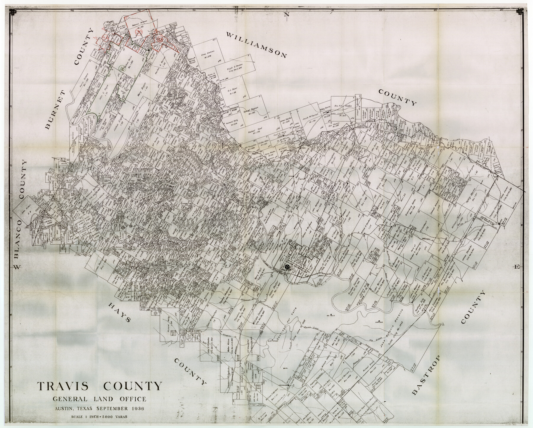
Travis County Working Sketch Graphic Index - north part
-
Map/Doc
76717
-
Collection
General Map Collection
-
Object Dates
9/1936 (Creation Date)
-
People and Organizations
J.O. Barrow (Draftsman)
-
Counties
Travis
-
Subjects
County Surveying Working Sketch
-
Height x Width
43.0 x 53.2 inches
109.2 x 135.1 cm
-
Scale
1" = 2000 varas
-
Comments
North part of Travis County. See 76716 for the south part of this map.
Please note that Travis County Working Sketch 34 is missing and therefore no longer available.
Related maps
Travis County Working Sketch Graphic Index - south part

Print $40.00
- Digital $50.00
Travis County Working Sketch Graphic Index - south part
1936
Size 42.6 x 52.8 inches
Map/Doc 76716
Part of: General Map Collection
Hall County Sketch File 16

Print $20.00
- Digital $50.00
Hall County Sketch File 16
1892
Size 24.0 x 35.5 inches
Map/Doc 11608
Colorado County Sketch File 31

Print $4.00
- Digital $50.00
Colorado County Sketch File 31
1838
Size 12.8 x 7.8 inches
Map/Doc 18984
Jefferson County NRC Article 33.136 Sketch 1

Print $20.00
- Digital $50.00
Jefferson County NRC Article 33.136 Sketch 1
2002
Size 24.0 x 36.1 inches
Map/Doc 61601
Swisher County Sketch File 11

Print $58.00
- Digital $50.00
Swisher County Sketch File 11
1917
Size 9.1 x 8.3 inches
Map/Doc 37633
Crockett County Working Sketch 23

Print $20.00
- Digital $50.00
Crockett County Working Sketch 23
1919
Size 35.1 x 33.7 inches
Map/Doc 68356
Flight Mission No. BRE-1P, Frame 99, Nueces County

Print $20.00
- Digital $50.00
Flight Mission No. BRE-1P, Frame 99, Nueces County
1956
Size 18.4 x 22.2 inches
Map/Doc 86670
Brazoria County Sketch File 59

Print $364.00
- Digital $50.00
Brazoria County Sketch File 59
1996
Size 14.9 x 8.3 inches
Map/Doc 15398
Chambers County Sketch File 21a

Print $2.00
- Digital $50.00
Chambers County Sketch File 21a
1867
Size 10.2 x 6.6 inches
Map/Doc 17593
Nueces County Sketch File 26

Print $40.00
- Digital $50.00
Nueces County Sketch File 26
1890
Size 26.7 x 23.2 inches
Map/Doc 42184
Tyler County Working Sketch 20

Print $20.00
- Digital $50.00
Tyler County Working Sketch 20
1982
Size 41.0 x 32.7 inches
Map/Doc 69490
Bowie County Sketch File 6a

Print $8.00
- Digital $50.00
Bowie County Sketch File 6a
1927
Size 10.6 x 8.6 inches
Map/Doc 14844
El Paso County Boundary File 7a

Print $20.00
- Digital $50.00
El Paso County Boundary File 7a
Size 14.2 x 8.3 inches
Map/Doc 53094
You may also like

Briscoe County Working Sketch 6

Print $20.00
- Digital $50.00
Briscoe County Working Sketch 6
1940
Size 31.0 x 24.5 inches
Map/Doc 67809
Red River County Rolled Sketch 8

Print $20.00
- Digital $50.00
Red River County Rolled Sketch 8
Size 32.5 x 17.3 inches
Map/Doc 7474
Howard County Boundary File 4

Print $16.00
- Digital $50.00
Howard County Boundary File 4
Size 9.4 x 4.3 inches
Map/Doc 55158
Schleicher County Rolled Sketch 10

Print $20.00
- Digital $50.00
Schleicher County Rolled Sketch 10
Size 28.9 x 29.1 inches
Map/Doc 7752
Nolan County, Texas

Print $20.00
- Digital $50.00
Nolan County, Texas
1870
Size 23.9 x 19.5 inches
Map/Doc 744
Jim Wells County Boundary File 3

Print $10.00
- Digital $50.00
Jim Wells County Boundary File 3
Size 9.3 x 6.0 inches
Map/Doc 55546
[Plat of Survey 1, Block B]
![91448, [Plat of Survey 1, Block B], Twichell Survey Records](https://historictexasmaps.com/wmedia_w700/maps/91448-1.tif.jpg)
Print $3.00
- Digital $50.00
[Plat of Survey 1, Block B]
1907
Size 11.7 x 12.6 inches
Map/Doc 91448
Kaufman County Working Sketch 3

Print $2.00
- Digital $50.00
Kaufman County Working Sketch 3
1922
Size 11.9 x 8.0 inches
Map/Doc 66666
Plat of a survey of the North part of section 16, Block 362, Martha McBride, Presidio County, Texas

Print $4.00
- Digital $50.00
Plat of a survey of the North part of section 16, Block 362, Martha McBride, Presidio County, Texas
1989
Size 24.1 x 29.3 inches
Map/Doc 60520
The Rand McNally New Commercial Atlas Map of Texas

Print $20.00
- Digital $50.00
The Rand McNally New Commercial Atlas Map of Texas
1918
Size 28.6 x 40.2 inches
Map/Doc 95851
Bastrop County Sketch File 2

Print $4.00
- Digital $50.00
Bastrop County Sketch File 2
1858
Size 10.8 x 8.3 inches
Map/Doc 14042