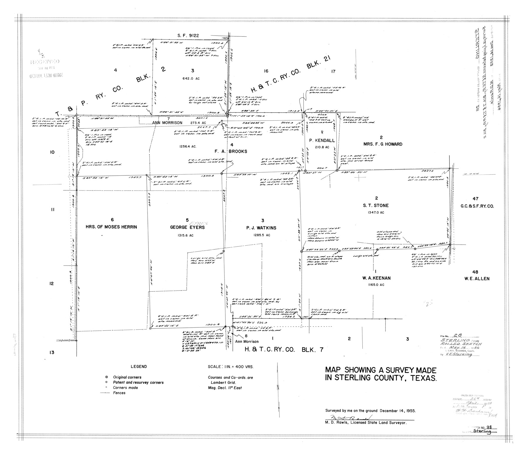
Sterling County Rolled Sketch 28
Map showing a survey made in Sterling County, Texas
-
Map/Doc
7853
-
Collection
General Map Collection
-
Object Dates
1955/12/14 (Survey Date)
1956/5/16 (File Date)
-
People and Organizations
M.D. Rawls (Surveyor/Engineer)
-
Counties
Sterling
-
Subjects
Surveying Rolled Sketch
-
Height x Width
28.8 x 33.4 inches
73.2 x 84.8 cm
-
Medium
mylar, print
-
Scale
1" = 400 varas
Part of: General Map Collection

Cameron County Sketch File 3

Print $42.00
- Digital $50.00
Cameron County Sketch File 3
1930
Size 11.1 x 8.8 inches
Map/Doc 17023
Montgomery County Sketch File 9

Print $6.00
- Digital $50.00
Montgomery County Sketch File 9
Size 9.0 x 7.6 inches
Map/Doc 31795
Galveston County NRC Article 33.136 Sketch 12

Print $28.00
- Digital $50.00
Galveston County NRC Article 33.136 Sketch 12
2002
Size 22.5 x 33.8 inches
Map/Doc 66899
Flight Mission No. DIX-10P, Frame 73, Aransas County

Print $20.00
- Digital $50.00
Flight Mission No. DIX-10P, Frame 73, Aransas County
1956
Size 18.7 x 22.4 inches
Map/Doc 83934
Key to Photo Index Sheets of Texas Coast Portion

Print $20.00
- Digital $50.00
Key to Photo Index Sheets of Texas Coast Portion
1954
Size 20.0 x 24.0 inches
Map/Doc 83436
Bastrop County Sketch File 9A

Print $40.00
- Digital $50.00
Bastrop County Sketch File 9A
Map/Doc 88484
Maps of Gulf Intracoastal Waterway, Texas - Sabine River to the Rio Grande and connecting waterways including ship channels

Print $20.00
- Digital $50.00
Maps of Gulf Intracoastal Waterway, Texas - Sabine River to the Rio Grande and connecting waterways including ship channels
1966
Size 14.5 x 22.2 inches
Map/Doc 61941
Crockett County Rolled Sketch 81

Print $20.00
- Digital $50.00
Crockett County Rolled Sketch 81
1958
Size 20.6 x 24.5 inches
Map/Doc 5621
Map of Denton County

Print $20.00
- Digital $50.00
Map of Denton County
1877
Size 20.7 x 18.6 inches
Map/Doc 3475
Lipscomb County

Print $20.00
- Digital $50.00
Lipscomb County
1878
Size 18.1 x 16.4 inches
Map/Doc 3816
Hudspeth County Working Sketch Graphic Index

Print $40.00
- Digital $50.00
Hudspeth County Working Sketch Graphic Index
1943
Size 53.7 x 39.3 inches
Map/Doc 76584
You may also like
[East line of Captiol Land in Deaf Smith, Castro and Lamb]
![90603, [East line of Captiol Land in Deaf Smith, Castro and Lamb], Twichell Survey Records](https://historictexasmaps.com/wmedia_w700/maps/90603-1.tif.jpg)
Print $20.00
- Digital $50.00
[East line of Captiol Land in Deaf Smith, Castro and Lamb]
Size 45.4 x 17.4 inches
Map/Doc 90603
Winkler County Working Sketch 12

Print $40.00
- Digital $50.00
Winkler County Working Sketch 12
1961
Size 59.3 x 50.0 inches
Map/Doc 72606
Parker County Working Sketch 27

Print $20.00
- Digital $50.00
Parker County Working Sketch 27
2009
Map/Doc 89001
Kerr County Rolled Sketch 27

Print $20.00
- Digital $50.00
Kerr County Rolled Sketch 27
1983
Size 33.1 x 33.5 inches
Map/Doc 6506
Right-of-way & Track Map Dawson Railway Operated by the El Paso & Southwestern Company Station 1444+61.7 to Station 1655+23.4

Print $40.00
- Digital $50.00
Right-of-way & Track Map Dawson Railway Operated by the El Paso & Southwestern Company Station 1444+61.7 to Station 1655+23.4
1910
Size 56.7 x 24.8 inches
Map/Doc 89655
[Edwards County]
![4940, [Edwards County], General Map Collection](https://historictexasmaps.com/wmedia_w700/maps/4940-1.tif.jpg)
Print $40.00
- Digital $50.00
[Edwards County]
1900
Size 48.7 x 32.7 inches
Map/Doc 4940
Eastland County Working Sketch 57

Print $20.00
- Digital $50.00
Eastland County Working Sketch 57
1985
Size 21.7 x 21.8 inches
Map/Doc 68838
Jefferson County Working Sketch 11

Print $20.00
- Digital $50.00
Jefferson County Working Sketch 11
1943
Size 46.6 x 43.0 inches
Map/Doc 66554
Karnes County Sketch File 5

Print $7.00
- Digital $50.00
Karnes County Sketch File 5
1849
Size 8.1 x 10.0 inches
Map/Doc 28554
Lavaca County Rolled Sketch 6

Print $20.00
- Digital $50.00
Lavaca County Rolled Sketch 6
1986
Size 44.8 x 33.9 inches
Map/Doc 10290
Plan of the Battle of Buena-Vista fought February 22nd and 23rd, 1847

Print $20.00
- Digital $50.00
Plan of the Battle of Buena-Vista fought February 22nd and 23rd, 1847
1847
Size 17.6 x 21.6 inches
Map/Doc 95829
Flight Mission No. CLL-1N, Frame 195, Willacy County

Print $20.00
- Digital $50.00
Flight Mission No. CLL-1N, Frame 195, Willacy County
1954
Size 18.5 x 22.3 inches
Map/Doc 87065