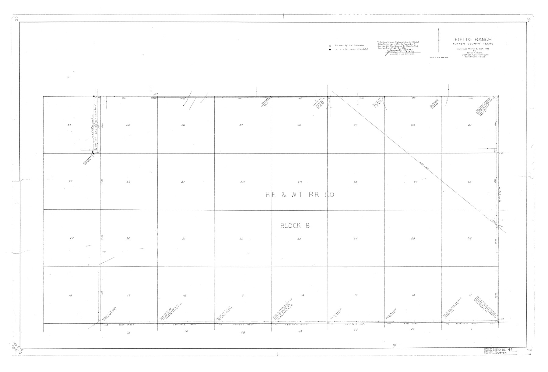
Sutton County Rolled Sketch 44
Fields Ranch, Sutton County, Texas
-
Map/Doc
7886
-
Collection
General Map Collection
-
Object Dates
1940 (Survey Date)
1941/4/1 (File Date)
-
People and Organizations
James K. Avera (Surveyor/Engineer)
-
Counties
Sutton
-
Subjects
Surveying Rolled Sketch
-
Height x Width
24.6 x 36.1 inches
62.5 x 91.7 cm
-
Scale
1" = 500 varas
Part of: General Map Collection
Bandera County Working Sketch 46

Print $20.00
- Digital $50.00
Bandera County Working Sketch 46
1981
Size 28.0 x 37.4 inches
Map/Doc 67642
Hutchinson County Sketch File 19

Print $16.00
- Digital $50.00
Hutchinson County Sketch File 19
1913
Size 8.0 x 5.2 inches
Map/Doc 27234
El Paso County Boundary File 2

Print $28.00
- Digital $50.00
El Paso County Boundary File 2
Size 13.2 x 8.2 inches
Map/Doc 53021
Brewster County Rolled Sketch C

Print $40.00
- Digital $50.00
Brewster County Rolled Sketch C
Size 39.0 x 71.8 inches
Map/Doc 8466
Harris County Rolled Sketch 67

Print $20.00
- Digital $50.00
Harris County Rolled Sketch 67
1940
Size 15.7 x 26.9 inches
Map/Doc 6109
Kinney County Sketch File 26

Print $20.00
- Digital $50.00
Kinney County Sketch File 26
1928
Size 20.4 x 18.8 inches
Map/Doc 11945
University Lands Situated in Robertson County

Print $20.00
- Digital $50.00
University Lands Situated in Robertson County
1841
Size 22.8 x 26.2 inches
Map/Doc 281
Map of Lands surveyed for the Deaf & Dumb Asylum on the head waters of the Leon River

Print $20.00
- Digital $50.00
Map of Lands surveyed for the Deaf & Dumb Asylum on the head waters of the Leon River
1857
Size 13.3 x 17.1 inches
Map/Doc 2209
Falls County Sketch File 2

Print $4.00
- Digital $50.00
Falls County Sketch File 2
1854
Size 13.1 x 8.3 inches
Map/Doc 22332
Flight Mission No. DQO-3K, Frame 41, Galveston County

Print $20.00
- Digital $50.00
Flight Mission No. DQO-3K, Frame 41, Galveston County
1952
Size 18.7 x 22.5 inches
Map/Doc 85082
Somervell County Rolled Sketch D

Print $20.00
- Digital $50.00
Somervell County Rolled Sketch D
1939
Size 17.3 x 21.0 inches
Map/Doc 7794
Polk County Sketch File 6

Print $4.00
- Digital $50.00
Polk County Sketch File 6
Size 7.1 x 9.4 inches
Map/Doc 34129
You may also like
General Highway Map, Collingsworth County, Texas

Print $20.00
General Highway Map, Collingsworth County, Texas
1940
Size 18.3 x 25.2 inches
Map/Doc 79053
Blanco County Rolled Sketch 12

Print $20.00
- Digital $50.00
Blanco County Rolled Sketch 12
1964
Size 17.3 x 20.0 inches
Map/Doc 5148
Potter County Sketch File 21

Print $6.00
- Digital $50.00
Potter County Sketch File 21
1930
Size 14.1 x 9.7 inches
Map/Doc 34413

Map of the Land Purchased by C.W. Post from the US, T, and OS Ranches situated in Garza and Lynn Counties, Texas

Print $40.00
- Digital $50.00
Map of the Land Purchased by C.W. Post from the US, T, and OS Ranches situated in Garza and Lynn Counties, Texas
Size 47.6 x 57.4 inches
Map/Doc 89948
Index sheet to accompany map of survey for connecting the inland waters along margin of the Gulf of Mexico from Donaldsonville in Louisiana to the Rio Grande River in Texas

Print $20.00
- Digital $50.00
Index sheet to accompany map of survey for connecting the inland waters along margin of the Gulf of Mexico from Donaldsonville in Louisiana to the Rio Grande River in Texas
1874
Size 18.1 x 26.9 inches
Map/Doc 72694
Crockett County Sketch File 10

Print $20.00
- Digital $50.00
Crockett County Sketch File 10
Size 14.0 x 12.7 inches
Map/Doc 75924
Jackson County Boundary File 1a

Print $12.00
- Digital $50.00
Jackson County Boundary File 1a
Size 12.8 x 8.0 inches
Map/Doc 55431
The Republic County of Lamar. December 29, 1845

Print $20.00
The Republic County of Lamar. December 29, 1845
2020
Size 16.4 x 21.7 inches
Map/Doc 96207
Trinity County Sketch File 35

Print $34.00
- Digital $50.00
Trinity County Sketch File 35
1920
Size 8.3 x 9.1 inches
Map/Doc 38580
Bird's Eye View of the City of Waco

Print $20.00
Bird's Eye View of the City of Waco
1873
Size 19.6 x 24.0 inches
Map/Doc 89211
Montgomery County Working Sketch Graphic Index, Sheet 2 (Sketches 36 to Most Recent)

Print $40.00
- Digital $50.00
Montgomery County Working Sketch Graphic Index, Sheet 2 (Sketches 36 to Most Recent)
1943
Size 42.9 x 51.9 inches
Map/Doc 76647