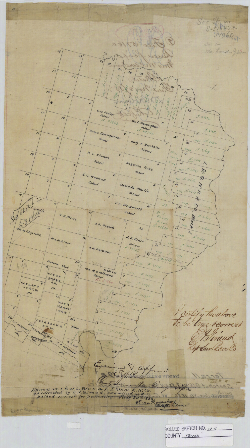
Terrell County Rolled Sketch 19A
[Surveys 1 to 31 in Block no. 1, I. & G. N. R.R. Co.]
-
Map/Doc
7928
-
Collection
General Map Collection
-
Object Dates
1886/1/30 (Creation Date)
-
People and Organizations
E.A. Giraud (Surveyor/Engineer)
-
Counties
Terrell
-
Subjects
Surveying Rolled Sketch
-
Height x Width
19.8 x 11.1 inches
50.3 x 28.2 cm
-
Medium
linen, manuscript
Part of: General Map Collection
Flight Mission No. BQR-7K, Frame 26, Brazoria County

Print $20.00
- Digital $50.00
Flight Mission No. BQR-7K, Frame 26, Brazoria County
1952
Size 18.7 x 22.3 inches
Map/Doc 84024
[Blocks 341, G-5, G-12, TCRRCo.]
![60298, [Blocks 341, G-5, G-12, TCRRCo.], General Map Collection](https://historictexasmaps.com/wmedia_w700/maps/60298-1.tif.jpg)
Print $20.00
- Digital $50.00
[Blocks 341, G-5, G-12, TCRRCo.]
1954
Size 15.1 x 26.1 inches
Map/Doc 60298
Zavala County Sketch File 41

Print $20.00
- Digital $50.00
Zavala County Sketch File 41
1900
Size 24.0 x 21.6 inches
Map/Doc 12731

Right of Way and Track Map, the Missouri, Kansas and Texas Ry. of Texas - Henrietta Division

Print $20.00
- Digital $50.00
Right of Way and Track Map, the Missouri, Kansas and Texas Ry. of Texas - Henrietta Division
1918
Size 11.7 x 26.8 inches
Map/Doc 64767
Crane County Sketch File 28

Print $6.00
- Digital $50.00
Crane County Sketch File 28
1953
Size 11.5 x 9.1 inches
Map/Doc 19605
Hansford County Working Sketch 2

Print $40.00
- Digital $50.00
Hansford County Working Sketch 2
1934
Size 42.7 x 54.4 inches
Map/Doc 63374
Runnels County Rolled Sketch 35

Print $20.00
- Digital $50.00
Runnels County Rolled Sketch 35
1950
Size 34.1 x 44.6 inches
Map/Doc 7523
Supreme Court of the United States, October Term, 1923, No. 15, Original - The State of Oklahoma, Complainant vs. The State of Texas, Defendant, The United States, Intervener; Report of the Boundary Commissioners

Print $20.00
- Digital $50.00
Supreme Court of the United States, October Term, 1923, No. 15, Original - The State of Oklahoma, Complainant vs. The State of Texas, Defendant, The United States, Intervener; Report of the Boundary Commissioners
1923
Size 46.4 x 33.4 inches
Map/Doc 75122
Coleman County Sketch File 7

Print $2.00
- Digital $50.00
Coleman County Sketch File 7
Size 8.2 x 10.3 inches
Map/Doc 18674
Schleicher County Sketch File 21

Print $40.00
- Digital $50.00
Schleicher County Sketch File 21
1936
Size 14.5 x 15.2 inches
Map/Doc 36510
Flight Mission No. BRA-16M, Frame 106, Jefferson County

Print $20.00
- Digital $50.00
Flight Mission No. BRA-16M, Frame 106, Jefferson County
1953
Size 18.6 x 22.3 inches
Map/Doc 85718
You may also like
Coke County Sketch File 8

Print $20.00
- Digital $50.00
Coke County Sketch File 8
Size 20.2 x 27.8 inches
Map/Doc 11106
Map of Limestone County

Print $20.00
- Digital $50.00
Map of Limestone County
1869
Size 22.1 x 22.4 inches
Map/Doc 3818
Map of the Southern Pacific and connecting lines

Print $20.00
- Digital $50.00
Map of the Southern Pacific and connecting lines
1897
Size 8.7 x 15.9 inches
Map/Doc 95763
Rio Grande, Hargill Sheet

Print $20.00
- Digital $50.00
Rio Grande, Hargill Sheet
1935
Size 37.1 x 38.1 inches
Map/Doc 65121
Crockett County Working Sketch 98

Print $20.00
- Digital $50.00
Crockett County Working Sketch 98
1980
Size 42.8 x 35.9 inches
Map/Doc 68431
Sur. Sketch S. F. 6855

Print $20.00
- Digital $50.00
Sur. Sketch S. F. 6855
Size 20.2 x 10.2 inches
Map/Doc 90788
Lampasas County Sketch File 22

Print $2.00
- Digital $50.00
Lampasas County Sketch File 22
2007
Size 14.0 x 8.5 inches
Map/Doc 93653
Brewster County Sketch File A

Print $40.00
- Digital $50.00
Brewster County Sketch File A
1910
Size 18.6 x 19.9 inches
Map/Doc 10974
Crosby County Working Sketch 14

Print $20.00
- Digital $50.00
Crosby County Working Sketch 14
1976
Size 41.6 x 32.3 inches
Map/Doc 68448
Hale County Working Sketch 3

Print $20.00
- Digital $50.00
Hale County Working Sketch 3
1963
Size 27.0 x 22.2 inches
Map/Doc 63323
[Galveston, Harrisburg & San Antonio through El Paso County]
![64005, [Galveston, Harrisburg & San Antonio through El Paso County], General Map Collection](https://historictexasmaps.com/wmedia_w700/maps/64005.tif.jpg)
Print $20.00
- Digital $50.00
[Galveston, Harrisburg & San Antonio through El Paso County]
1906
Size 13.3 x 33.6 inches
Map/Doc 64005
Harrison County Working Sketch 12

Print $20.00
- Digital $50.00
Harrison County Working Sketch 12
1960
Size 26.6 x 31.4 inches
Map/Doc 66032