Webb County Rolled Sketch EF4
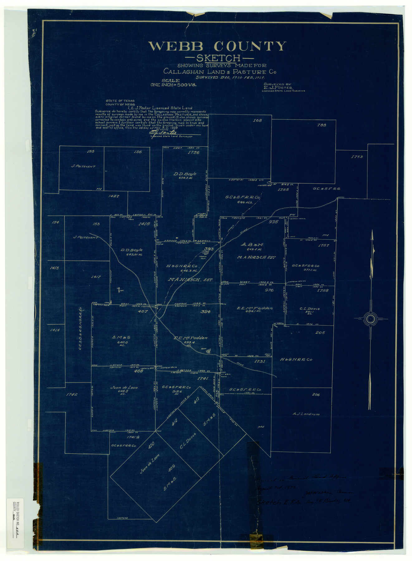
Webb County sketch showing surveys made for Callaghan Land & Pasture Co.
-
Map/Doc
8226
-
Collection
General Map Collection
-
Object Dates
1929 (Survey Date)
1932/8/3 (File Date)
1929/5/28 (Creation Date)
-
People and Organizations
E.J. Foster (Surveyor/Engineer)
-
Counties
Webb
-
Subjects
Surveying Rolled Sketch
-
Height x Width
33.2 x 24.4 inches
84.3 x 62.0 cm
-
Medium
blueprint/diazo
-
Scale
1" = 500 varas
Related maps
Webb County Sketch File EF

Print $38.00
- Digital $50.00
Webb County Sketch File EF
1932
Size 9.2 x 8.5 inches
Map/Doc 39681
Part of: General Map Collection
Brewster County Working Sketch 110

Print $40.00
- Digital $50.00
Brewster County Working Sketch 110
1982
Size 48.9 x 40.1 inches
Map/Doc 67710
Hall County Sketch File 32a

Print $56.00
- Digital $50.00
Hall County Sketch File 32a
1911
Size 14.4 x 8.6 inches
Map/Doc 24846
Bosque County Working Sketch 3

Print $20.00
- Digital $50.00
Bosque County Working Sketch 3
1901
Size 16.5 x 20.4 inches
Map/Doc 78192
Runnels County Working Sketch 29

Print $20.00
- Digital $50.00
Runnels County Working Sketch 29
1959
Size 27.1 x 30.0 inches
Map/Doc 63625
Bosque County Working Sketch 10

Print $20.00
- Digital $50.00
Bosque County Working Sketch 10
1944
Size 19.3 x 20.3 inches
Map/Doc 67443
Liberty County Rolled Sketch JP

Print $40.00
- Digital $50.00
Liberty County Rolled Sketch JP
Size 43.6 x 70.1 inches
Map/Doc 9566

Menard County Working Sketch 2

Print $20.00
- Digital $50.00
Menard County Working Sketch 2
1906
Size 17.8 x 12.5 inches
Map/Doc 70949
Calhoun County Rolled Sketch 14

Print $20.00
- Digital $50.00
Calhoun County Rolled Sketch 14
Size 21.5 x 40.2 inches
Map/Doc 5461
Padre Island National Seashore

Print $4.00
- Digital $50.00
Padre Island National Seashore
Size 16.0 x 21.8 inches
Map/Doc 60527
Lynn County Boundary File 9

Print $24.00
- Digital $50.00
Lynn County Boundary File 9
Size 11.3 x 8.8 inches
Map/Doc 56657
Hood County Sketch File 2

Print $4.00
- Digital $50.00
Hood County Sketch File 2
Size 9.7 x 8.2 inches
Map/Doc 26571
You may also like
Jeff Davis County Sketch File 45

Print $10.00
- Digital $50.00
Jeff Davis County Sketch File 45
1890
Size 14.0 x 8.5 inches
Map/Doc 28075
Zavala County Sketch File B

Print $34.00
- Digital $50.00
Zavala County Sketch File B
1908
Size 13.5 x 8.9 inches
Map/Doc 41364
Texas Highway Map Points of Interest, Recreational Facilities Guide, Special Events Calendar [Verso]
![94188, Texas Highway Map Points of Interest, Recreational Facilities Guide, Special Events Calendar [Verso], General Map Collection](https://historictexasmaps.com/wmedia_w700/maps/94188.tif.jpg)
Texas Highway Map Points of Interest, Recreational Facilities Guide, Special Events Calendar [Verso]
1963
Size 31.0 x 18.3 inches
Map/Doc 94188

No. 2 Chart of Corpus Christi Pass, Texas

Print $20.00
- Digital $50.00
No. 2 Chart of Corpus Christi Pass, Texas
1878
Size 18.2 x 27.3 inches
Map/Doc 73017
Tom Green County Rolled Sketch 2

Print $20.00
- Digital $50.00
Tom Green County Rolled Sketch 2
Size 17.2 x 26.8 inches
Map/Doc 7992
Flight Mission No. CRK-3P, Frame 65, Refugio County

Print $20.00
- Digital $50.00
Flight Mission No. CRK-3P, Frame 65, Refugio County
1956
Size 18.5 x 22.4 inches
Map/Doc 86907
Subdivisions of Capitol Leagues 112, 113, 114, 115, and parts of 110 and 111

Print $2.00
- Digital $50.00
Subdivisions of Capitol Leagues 112, 113, 114, 115, and parts of 110 and 111
1906
Size 6.3 x 8.3 inches
Map/Doc 90518
Rusk County Working Sketch 25

Print $20.00
- Digital $50.00
Rusk County Working Sketch 25
1941
Size 39.8 x 25.1 inches
Map/Doc 63661
Coast Chart No. 212 - From Latitude 26° 33' to the Rio Grande Texas

Print $20.00
- Digital $50.00
Coast Chart No. 212 - From Latitude 26° 33' to the Rio Grande Texas
1886
Size 18.3 x 27.4 inches
Map/Doc 72825
Fractional Township No. 10 South Range No. 9 East of the Indian Meridian, Indian Territory

Print $20.00
- Digital $50.00
Fractional Township No. 10 South Range No. 9 East of the Indian Meridian, Indian Territory
1898
Size 19.3 x 24.4 inches
Map/Doc 75217
Jeff Davis County Sketch File 25

Print $32.00
- Digital $50.00
Jeff Davis County Sketch File 25
1886
Size 11.3 x 8.5 inches
Map/Doc 27992