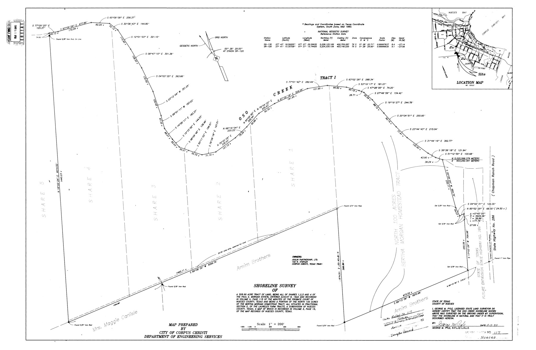
Nueces County Rolled Sketch 117
[Plat, survey report, and exhibits of the shoreline of Oso Creek on the north boundary of fractional Section D, Laureles Farm Tracts]
-
Map/Doc
8407
-
Collection
General Map Collection
-
Object Dates
1993 (Creation Date)
4/14/1993 (File Date)
-
People and Organizations
George M. Pyle (Surveyor/Engineer)
-
Counties
Nueces
-
Subjects
Surveying Rolled Sketch
-
Height x Width
24.5 x 37.5 inches
62.2 x 95.3 cm
Part of: General Map Collection
Flight Mission No. DAG-21K, Frame 37, Matagorda County

Print $20.00
- Digital $50.00
Flight Mission No. DAG-21K, Frame 37, Matagorda County
1952
Size 18.5 x 22.4 inches
Map/Doc 86404
Winkler County Working Sketch 9

Print $40.00
- Digital $50.00
Winkler County Working Sketch 9
1950
Size 42.9 x 50.0 inches
Map/Doc 72603
Jasper County Sketch File 13

Print $4.00
- Digital $50.00
Jasper County Sketch File 13
1880
Size 12.1 x 8.7 inches
Map/Doc 27804
Callahan County

Print $20.00
- Digital $50.00
Callahan County
1879
Size 22.0 x 17.9 inches
Map/Doc 3362
[Northern Bexar District]
![1963, [Northern Bexar District], General Map Collection](https://historictexasmaps.com/wmedia_w700/maps/1963-1.tif.jpg)
Print $20.00
- Digital $50.00
[Northern Bexar District]
1852
Size 46.0 x 26.5 inches
Map/Doc 1963
Aransas County Rolled Sketch 16

Print $40.00
- Digital $50.00
Aransas County Rolled Sketch 16
1965
Size 45.9 x 92.9 inches
Map/Doc 9005
Comal County Working Sketch 7

Print $20.00
- Digital $50.00
Comal County Working Sketch 7
1950
Size 42.1 x 31.8 inches
Map/Doc 68173
Liberty County Sketch File 59

Print $6.00
- Digital $50.00
Liberty County Sketch File 59
1943
Size 14.2 x 8.8 inches
Map/Doc 30068
Ector County Working Sketch 25

Print $20.00
- Digital $50.00
Ector County Working Sketch 25
1961
Size 29.6 x 34.2 inches
Map/Doc 68868
[Surveys in Austin's Colony along New Year's Creek]
![204, [Surveys in Austin's Colony along New Year's Creek], General Map Collection](https://historictexasmaps.com/wmedia_w700/maps/204.tif.jpg)
Print $20.00
- Digital $50.00
[Surveys in Austin's Colony along New Year's Creek]
1828
Size 12.9 x 15.5 inches
Map/Doc 204
Dickens County Working Sketch 7

Print $20.00
- Digital $50.00
Dickens County Working Sketch 7
1947
Size 26.1 x 31.1 inches
Map/Doc 68655
Edwards County Sketch File 24

Print $6.00
- Digital $50.00
Edwards County Sketch File 24
Size 8.9 x 13.2 inches
Map/Doc 21751
You may also like
General Highway Map, Brown County, Texas

Print $20.00
General Highway Map, Brown County, Texas
1940
Size 25.0 x 18.4 inches
Map/Doc 79031
Wilbarger County Rolled Sketch 10

Print $20.00
- Digital $50.00
Wilbarger County Rolled Sketch 10
1983
Size 37.6 x 23.8 inches
Map/Doc 8259
[Sketch in Edwards & Sutton Counties, Texas]
![4371, [Sketch in Edwards & Sutton Counties, Texas], Maddox Collection](https://historictexasmaps.com/wmedia_w700/maps/4371.tif.jpg)
Print $20.00
- Digital $50.00
[Sketch in Edwards & Sutton Counties, Texas]
Size 16.7 x 30.2 inches
Map/Doc 4371
Map of Wood County, Texas

Print $20.00
- Digital $50.00
Map of Wood County, Texas
1879
Size 17.5 x 17.1 inches
Map/Doc 659
Traveller's Map of the State of Texas

Print $20.00
- Digital $50.00
Traveller's Map of the State of Texas
1867
Size 43.4 x 41.6 inches
Map/Doc 93906
Val Verde County Sketch File A1 1/2

Print $20.00
- Digital $50.00
Val Verde County Sketch File A1 1/2
Size 24.8 x 17.3 inches
Map/Doc 12539
Concho County Sketch File 27

Print $8.00
- Digital $50.00
Concho County Sketch File 27
1885
Size 11.3 x 8.8 inches
Map/Doc 19162
K&E Both's Patent Section Liner and Scale Divider #1160

K&E Both's Patent Section Liner and Scale Divider #1160
Size 2.4 x 15.5 inches
Map/Doc 97304
Howard County Working Sketch Graphic Index

Print $20.00
- Digital $50.00
Howard County Working Sketch Graphic Index
1922
Size 42.5 x 36.3 inches
Map/Doc 76583
[Block H, Block 24]
![92598, [Block H, Block 24], Twichell Survey Records](https://historictexasmaps.com/wmedia_w700/maps/92598-1.tif.jpg)
Print $20.00
- Digital $50.00
[Block H, Block 24]
Size 30.2 x 17.0 inches
Map/Doc 92598
Hunt County Sketch File 37

Print $4.00
- Digital $50.00
Hunt County Sketch File 37
Size 11.4 x 8.1 inches
Map/Doc 27155
Midland County, Texas

Print $20.00
- Digital $50.00
Midland County, Texas
1888
Size 22.4 x 17.5 inches
Map/Doc 653