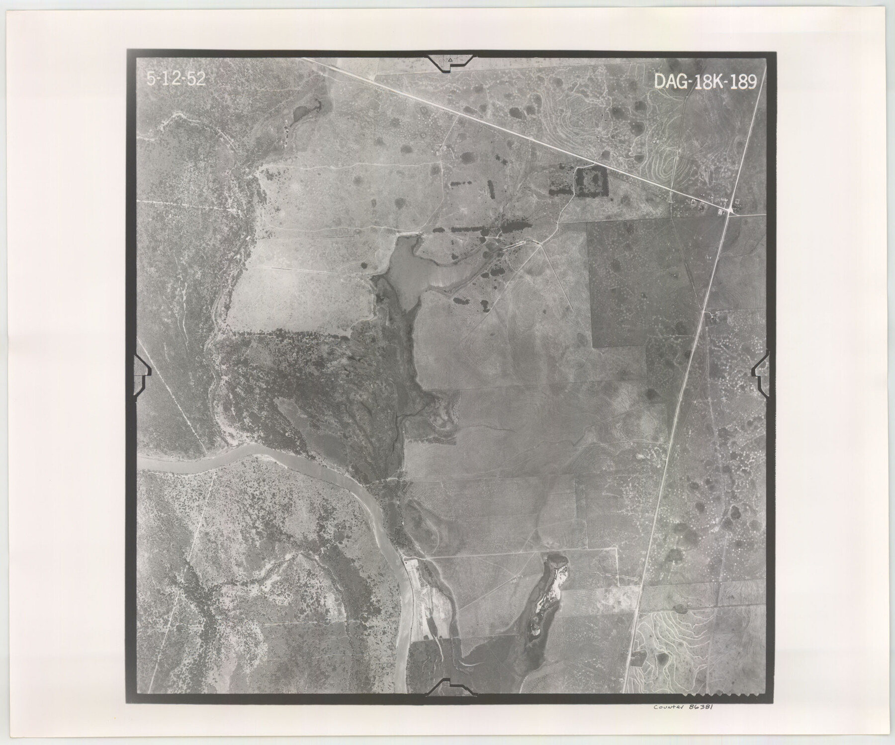
Flight Mission No. DAG-18K, Frame 189, Matagorda County
DAG-18K-189
-
Map/Doc
86381
-
Collection
General Map Collection
-
Object Dates
1952/5/12 (Creation Date)
-
People and Organizations
U. S. Department of Agriculture (Publisher)
-
Counties
Matagorda
-
Subjects
Aerial Photograph
-
Height x Width
18.5 x 22.3 inches
47.0 x 56.6 cm
-
Comments
Flown by Aero Exploration Company of Tulsa, Oklahoma.
Part of: General Map Collection
Montague County Sketch File 27

Print $20.00
- Digital $50.00
Montague County Sketch File 27
1954
Size 15.8 x 22.5 inches
Map/Doc 12109
Flight Mission No. CRC-5R, Frame 40, Chambers County

Print $20.00
- Digital $50.00
Flight Mission No. CRC-5R, Frame 40, Chambers County
1956
Size 18.6 x 22.4 inches
Map/Doc 84959
Marion County Working Sketch 12a

Print $20.00
- Digital $50.00
Marion County Working Sketch 12a
1953
Size 23.9 x 33.2 inches
Map/Doc 70788
Chambers County Sketch File 18

Print $40.00
- Digital $50.00
Chambers County Sketch File 18
1879
Size 24.6 x 8.1 inches
Map/Doc 17569
[Surveys in the Bexar District along the Frio and Leona Rivers]
![136, [Surveys in the Bexar District along the Frio and Leona Rivers], General Map Collection](https://historictexasmaps.com/wmedia_w700/maps/136.tif.jpg)
Print $20.00
- Digital $50.00
[Surveys in the Bexar District along the Frio and Leona Rivers]
1842
Size 16.2 x 12.2 inches
Map/Doc 136
Polk County Sketch File 40

Print $4.00
- Digital $50.00
Polk County Sketch File 40
Size 10.9 x 8.5 inches
Map/Doc 34290
Washington County Sketch File 4

Print $4.00
- Digital $50.00
Washington County Sketch File 4
1863
Size 12.8 x 7.8 inches
Map/Doc 39650
Dimmit County Working Sketch 34

Print $20.00
- Digital $50.00
Dimmit County Working Sketch 34
1959
Size 22.8 x 17.0 inches
Map/Doc 68695
Dickens County Sketch File 34

Print $22.00
- Digital $50.00
Dickens County Sketch File 34
1938
Size 8.5 x 8.7 inches
Map/Doc 21030
Flight Mission No. BQR-16K, Frame 35, Brazoria County

Print $20.00
- Digital $50.00
Flight Mission No. BQR-16K, Frame 35, Brazoria County
1952
Size 18.5 x 22.2 inches
Map/Doc 84102
Zavala County Sketch File 1

Print $20.00
- Digital $50.00
Zavala County Sketch File 1
Size 28.5 x 22.7 inches
Map/Doc 12725
Sterling County

Print $40.00
- Digital $50.00
Sterling County
1926
Size 48.5 x 34.7 inches
Map/Doc 63048
You may also like
A Pocket Guide to Austin, Texas - Area Map and Downtown Map

A Pocket Guide to Austin, Texas - Area Map and Downtown Map
Size 17.2 x 20.2 inches
Map/Doc 94386
Harris County Working Sketch 46

Print $20.00
- Digital $50.00
Harris County Working Sketch 46
1942
Size 19.8 x 17.7 inches
Map/Doc 65938
Rio Grande - Rio Grande Sheet

Print $40.00
- Digital $50.00
Rio Grande - Rio Grande Sheet
1929
Size 53.9 x 27.3 inches
Map/Doc 65105
Brewster County Rolled Sketch 121A

Print $40.00
- Digital $50.00
Brewster County Rolled Sketch 121A
1946
Size 37.4 x 54.5 inches
Map/Doc 8518
Lipscomb County Boundary File 1

Print $16.00
- Digital $50.00
Lipscomb County Boundary File 1
Size 9.0 x 8.0 inches
Map/Doc 56307
Gulf Oil Corp. Fishgide - Port Isabel

Gulf Oil Corp. Fishgide - Port Isabel
1960
Size 22.0 x 11.9 inches
Map/Doc 75980
Brewster County Rolled Sketch 66

Print $20.00
- Digital $50.00
Brewster County Rolled Sketch 66
1940
Size 33.0 x 36.2 inches
Map/Doc 8490
Culberson Co.

Print $40.00
- Digital $50.00
Culberson Co.
1943
Size 52.2 x 33.2 inches
Map/Doc 73124
Randall County Boundary File 4

Print $10.00
- Digital $50.00
Randall County Boundary File 4
Size 14.4 x 8.9 inches
Map/Doc 58129
Jack County Rolled Sketch 1

Print $20.00
- Digital $50.00
Jack County Rolled Sketch 1
1963
Size 24.4 x 22.5 inches
Map/Doc 6331
El Paso County Working Sketch 43

Print $20.00
- Digital $50.00
El Paso County Working Sketch 43
Size 22.1 x 26.1 inches
Map/Doc 69065
