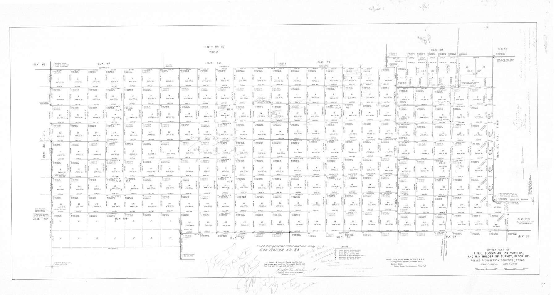
Culberson County Rolled Sketch 60
Survey plat of P.S.L. Blocks 45, 109 thru 115, and W.N. Holder SF survey, Block 112 [and coordinate sheets]
-
Map/Doc
8761
-
Collection
General Map Collection
-
Object Dates
1968/7/24 (Creation Date)
1984/4/3 (File Date)
-
People and Organizations
Joseph W. Luchini (Surveyor/Engineer)
-
Counties
Culberson
-
Subjects
Surveying Rolled Sketch
-
Height x Width
58.9 x 31.3 inches
149.6 x 79.5 cm
-
Medium
multi-page, multi-format
Part of: General Map Collection
Flight Mission No. CLL-1N, Frame 33, Willacy County

Print $20.00
- Digital $50.00
Flight Mission No. CLL-1N, Frame 33, Willacy County
1954
Size 18.4 x 22.1 inches
Map/Doc 87014
Starr County Rolled Sketch 21

Print $20.00
- Digital $50.00
Starr County Rolled Sketch 21
1921
Size 24.2 x 14.0 inches
Map/Doc 7805
Nueces County NRC Article 33.136 Location Key Sheet

Print $20.00
- Digital $50.00
Nueces County NRC Article 33.136 Location Key Sheet
1975
Size 27.0 x 23.0 inches
Map/Doc 88585
Brazoria County Rolled Sketch 18B

Print $20.00
- Digital $50.00
Brazoria County Rolled Sketch 18B
1914
Size 10.0 x 17.3 inches
Map/Doc 5165
Railroad Track Map, H&TCRRCo., Falls County, Texas

Print $4.00
- Digital $50.00
Railroad Track Map, H&TCRRCo., Falls County, Texas
1918
Size 11.4 x 18.7 inches
Map/Doc 62857
Johnson County Sketch File 15

Print $2.00
- Digital $50.00
Johnson County Sketch File 15
1881
Size 8.1 x 7.3 inches
Map/Doc 28455
Uvalde County Sketch File 16a

Print $6.00
- Digital $50.00
Uvalde County Sketch File 16a
Size 11.0 x 13.4 inches
Map/Doc 38995
Map of Callahan County

Print $20.00
- Digital $50.00
Map of Callahan County
1896
Size 22.9 x 19.0 inches
Map/Doc 3363
Loving County Rolled Sketch 17

Print $40.00
- Digital $50.00
Loving County Rolled Sketch 17
2022
Size 38.2 x 49.3 inches
Map/Doc 97292
Galveston County Sketch File 16

Print $6.00
- Digital $50.00
Galveston County Sketch File 16
Size 7.8 x 6.3 inches
Map/Doc 23384
Motley County Working Sketch 2

Print $20.00
- Digital $50.00
Motley County Working Sketch 2
1895
Size 17.3 x 21.3 inches
Map/Doc 71207
Ector County Rolled Sketch 12

Print $38.00
- Digital $50.00
Ector County Rolled Sketch 12
Size 10.1 x 15.4 inches
Map/Doc 44314
You may also like
Kleberg County Rolled Sketch 10-14

Print $20.00
- Digital $50.00
Kleberg County Rolled Sketch 10-14
1951
Size 38.0 x 33.2 inches
Map/Doc 9404
Presidio County Working Sketch 48

Print $20.00
- Digital $50.00
Presidio County Working Sketch 48
1950
Size 36.2 x 31.0 inches
Map/Doc 71725
Flight Mission No. DAG-21K, Frame 123, Matagorda County

Print $20.00
- Digital $50.00
Flight Mission No. DAG-21K, Frame 123, Matagorda County
1952
Size 18.5 x 22.4 inches
Map/Doc 86449
General Highway Map. Detail of Cities and Towns in Austin County, Texas [Sealy and Bellville, etc.]
![79358, General Highway Map. Detail of Cities and Towns in Austin County, Texas [Sealy and Bellville, etc.], Texas State Library and Archives](https://historictexasmaps.com/wmedia_w700/maps/79358.tif.jpg)
Print $20.00
General Highway Map. Detail of Cities and Towns in Austin County, Texas [Sealy and Bellville, etc.]
1961
Size 18.2 x 25.0 inches
Map/Doc 79358
Terrell County Working Sketch 76

Print $20.00
- Digital $50.00
Terrell County Working Sketch 76
1982
Size 31.8 x 20.1 inches
Map/Doc 69597
General Highway Map, Baylor County, Texas

Print $20.00
General Highway Map, Baylor County, Texas
1940
Size 18.3 x 25.1 inches
Map/Doc 79013
Matagorda County Boundary File 1b

Print $6.00
- Digital $50.00
Matagorda County Boundary File 1b
Size 14.2 x 8.5 inches
Map/Doc 56893
Flight Mission No. CRC-3R, Frame 206, Chambers County

Print $20.00
- Digital $50.00
Flight Mission No. CRC-3R, Frame 206, Chambers County
1956
Size 18.5 x 22.2 inches
Map/Doc 84861
Section C Tech Memorial Park, Inc.

Print $2.00
- Digital $50.00
Section C Tech Memorial Park, Inc.
Size 8.1 x 10.5 inches
Map/Doc 92351
Cass County Sketch File 3

Print $4.00
- Digital $50.00
Cass County Sketch File 3
Size 12.8 x 8.5 inches
Map/Doc 17396
Castro County Working Sketch 7

Print $40.00
- Digital $50.00
Castro County Working Sketch 7
1975
Size 42.8 x 53.1 inches
Map/Doc 67902
Orange County Working Sketch 41

Print $20.00
- Digital $50.00
Orange County Working Sketch 41
1979
Size 28.0 x 18.2 inches
Map/Doc 71373