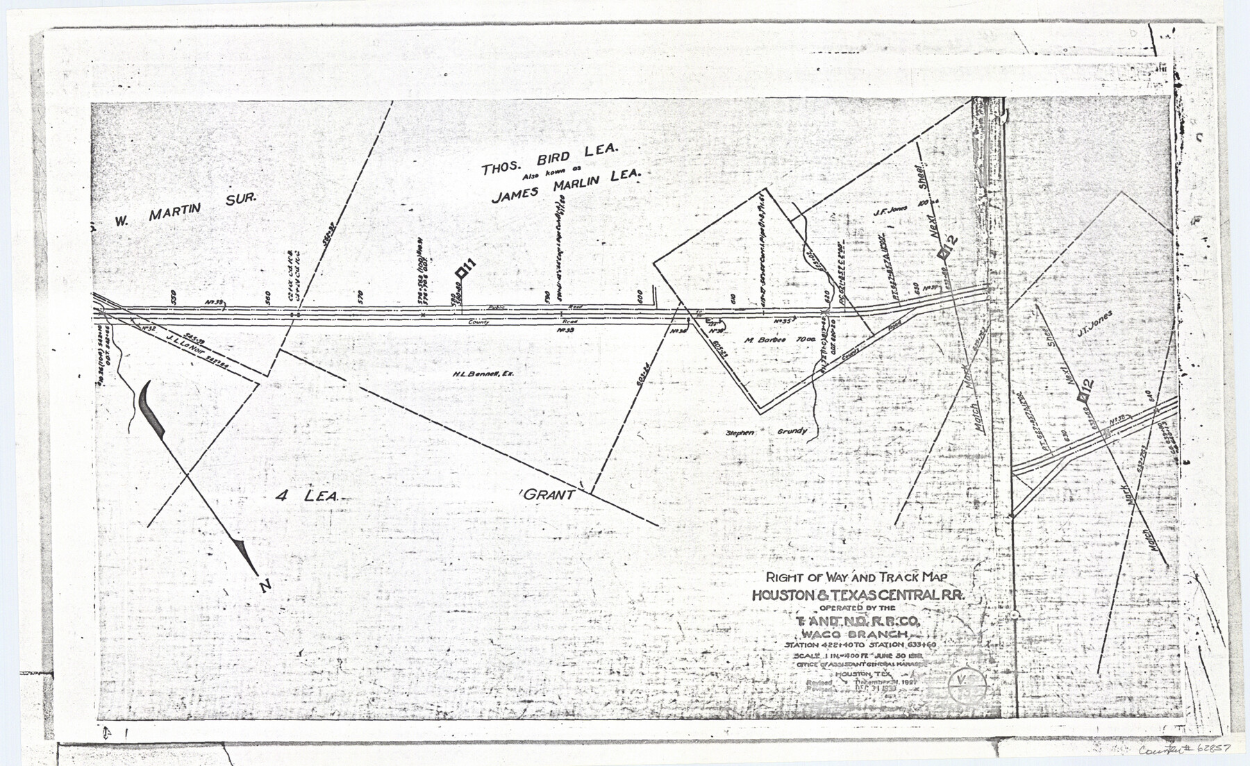
Railroad Track Map, H&TCRRCo., Falls County, Texas
Right of Way and Track Map
K-7-79 flat folder
-
Map/Doc
62857
-
Collection
General Map Collection
-
Object Dates
1918 (Creation Date)
-
Counties
Falls
-
Subjects
Railroads
-
Height x Width
11.4 x 18.7 inches
29.0 x 47.5 cm
-
Comments
Operated by the Texas and New Orleans Railroad Company, Waco Branch.
Part of: General Map Collection
Edwards County Boundary File 29

Print $22.00
- Digital $50.00
Edwards County Boundary File 29
Size 15.4 x 31.0 inches
Map/Doc 65502
Hartley County

Print $40.00
- Digital $50.00
Hartley County
1925
Size 41.9 x 52.1 inches
Map/Doc 1851
Amistad International Reservoir on Rio Grande 95

Print $20.00
- Digital $50.00
Amistad International Reservoir on Rio Grande 95
1950
Size 28.5 x 40.1 inches
Map/Doc 75525
Wilson County Working Sketch 2

Print $20.00
- Digital $50.00
Wilson County Working Sketch 2
1950
Size 42.0 x 42.8 inches
Map/Doc 72582
Blanco County Rolled Sketch 10

Print $20.00
- Digital $50.00
Blanco County Rolled Sketch 10
Size 28.0 x 25.6 inches
Map/Doc 5146
Travis County Working Sketch 67

Print $20.00
- Digital $50.00
Travis County Working Sketch 67
2017
Size 24.6 x 36.6 inches
Map/Doc 94123
Nueces County Rolled Sketch 47

Print $20.00
- Digital $50.00
Nueces County Rolled Sketch 47
1953
Size 31.3 x 44.6 inches
Map/Doc 6886
Leon County Sketch File 12

Print $23.00
- Digital $50.00
Leon County Sketch File 12
1886
Size 9.5 x 11.5 inches
Map/Doc 29765
Map of Kendall County

Print $20.00
- Digital $50.00
Map of Kendall County
1899
Size 36.7 x 34.4 inches
Map/Doc 4999
Haskell County Rolled Sketch 2

Print $20.00
- Digital $50.00
Haskell County Rolled Sketch 2
1902
Size 34.5 x 27.1 inches
Map/Doc 6163
Irion County Sketch File 1

Print $20.00
- Digital $50.00
Irion County Sketch File 1
1881
Size 43.9 x 18.3 inches
Map/Doc 10615
Fractional Township No. 1N and Township No. 2N R. No. 2E, Deaf Smith and Parmer Counties comprising Capitol Leagues 439 and 452 and parts of Capitol Leagues 431, 432, 433, 438, 440, 451, 453, 458, 459, and 460

Print $20.00
- Digital $50.00
Fractional Township No. 1N and Township No. 2N R. No. 2E, Deaf Smith and Parmer Counties comprising Capitol Leagues 439 and 452 and parts of Capitol Leagues 431, 432, 433, 438, 440, 451, 453, 458, 459, and 460
1906
Size 27.1 x 22.4 inches
Map/Doc 93966
You may also like
Red River County Working Sketch 49

Print $20.00
- Digital $50.00
Red River County Working Sketch 49
1970
Size 31.3 x 21.5 inches
Map/Doc 72032
Flight Mission No. BRA-6M, Frame 146, Jefferson County

Print $20.00
- Digital $50.00
Flight Mission No. BRA-6M, Frame 146, Jefferson County
1953
Size 18.6 x 22.3 inches
Map/Doc 85447
Willacy County Sketch File 3

Print $2.00
- Digital $50.00
Willacy County Sketch File 3
Size 8.5 x 11.0 inches
Map/Doc 90000
Maps of Gulf Intracoastal Waterway, Texas - Sabine River to the Rio Grande and connecting waterways including ship channels

Print $20.00
- Digital $50.00
Maps of Gulf Intracoastal Waterway, Texas - Sabine River to the Rio Grande and connecting waterways including ship channels
1966
Size 14.6 x 22.3 inches
Map/Doc 61925
Hardin County Sketch File 54

Print $20.00
- Digital $50.00
Hardin County Sketch File 54
1924
Size 16.6 x 17.9 inches
Map/Doc 11635
Capitol Lands survey by J. T. Munson

Print $20.00
- Digital $50.00
Capitol Lands survey by J. T. Munson
Size 24.8 x 20.4 inches
Map/Doc 90585
Duval County Working Sketch 27

Print $20.00
- Digital $50.00
Duval County Working Sketch 27
1947
Size 20.7 x 16.8 inches
Map/Doc 68751
[Isaac Scott and J. Walker surveys and vicinity]
![92664, [Isaac Scott and J. Walker surveys and vicinity], Twichell Survey Records](https://historictexasmaps.com/wmedia_w700/maps/92664-1.tif.jpg)
Print $40.00
- Digital $50.00
[Isaac Scott and J. Walker surveys and vicinity]
Size 54.0 x 29.1 inches
Map/Doc 92664
Crockett County Working Sketch 7

Print $20.00
- Digital $50.00
Crockett County Working Sketch 7
1891
Size 18.4 x 21.7 inches
Map/Doc 68340

Marion County Sketch File 3

Print $8.00
- Digital $50.00
Marion County Sketch File 3
1860
Size 14.1 x 8.8 inches
Map/Doc 30566
