New Map of the State of Texas Compiled from J. De Cordova's large Map
-
Map/Doc
89253
-
Collection
General Map Collection
-
Object Dates
2010/1/19 (File Date)
-
People and Organizations
J. H. Colton and Co. (Publisher)
Joseph Hutchins Colton (Author)
-
Subjects
State of Texas
-
Height x Width
17.8 x 27.4 inches
45.2 x 69.6 cm
-
Comments
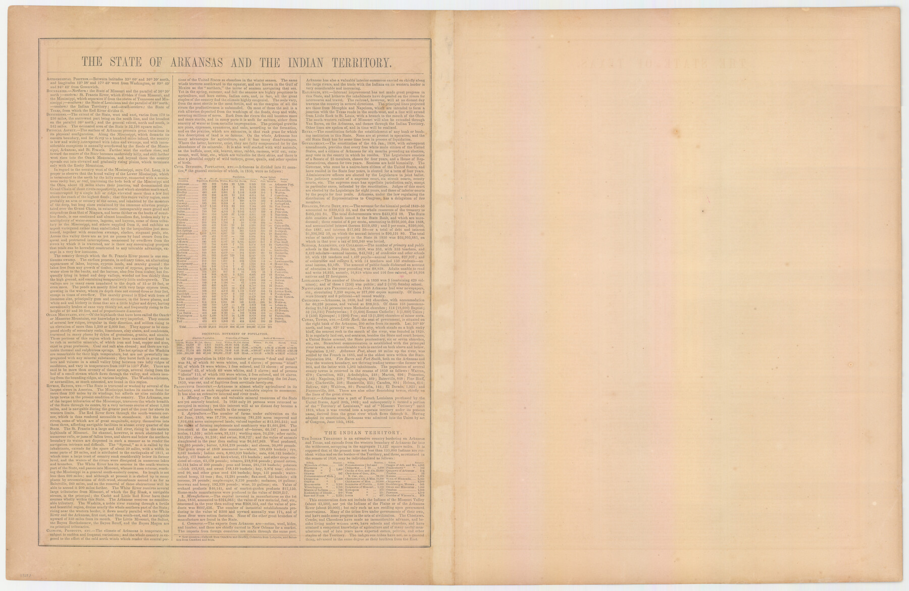
See counter 89253 for textual information titled "State of Arkansas and Indian Territory". See map number 76172 for another copy.
Part of: General Map Collection
Johnson County Boundary File 2a

Print $22.00
- Digital $50.00
Johnson County Boundary File 2a
Size 9.0 x 8.3 inches
Map/Doc 55566
Van Zandt County Sketch File 11

Print $4.00
- Digital $50.00
Van Zandt County Sketch File 11
1858
Size 10.2 x 8.1 inches
Map/Doc 39397
Culberson County Rolled Sketch 27

Print $20.00
- Digital $50.00
Culberson County Rolled Sketch 27
1922
Size 26.8 x 34.9 inches
Map/Doc 5656
Matagorda County Aerial Photograph Index Sheet 8

Print $20.00
- Digital $50.00
Matagorda County Aerial Photograph Index Sheet 8
1953
Size 19.6 x 23.8 inches
Map/Doc 83729
Sterling County Sketch File 18

Print $8.00
- Digital $50.00
Sterling County Sketch File 18
1939
Size 11.2 x 8.7 inches
Map/Doc 37161
Duval County Sketch File 38

Print $64.00
- Digital $50.00
Duval County Sketch File 38
Size 38.2 x 19.5 inches
Map/Doc 10372
Bee County Sketch File 8a

Print $8.00
- Digital $50.00
Bee County Sketch File 8a
1874
Size 6.0 x 7.6 inches
Map/Doc 14283
Taylor County Rolled Sketch 29

Print $20.00
- Digital $50.00
Taylor County Rolled Sketch 29
Size 20.2 x 24.2 inches
Map/Doc 7922
Pecos County Sketch File 38

Print $4.00
- Digital $50.00
Pecos County Sketch File 38
1895
Size 11.3 x 8.8 inches
Map/Doc 33720
Hardin County Working Sketch 2

Print $20.00
- Digital $50.00
Hardin County Working Sketch 2
1903
Size 23.2 x 21.9 inches
Map/Doc 63400
Grayson County Working Sketch 12

Print $4.00
- Digital $50.00
Grayson County Working Sketch 12
1951
Size 25.7 x 24.0 inches
Map/Doc 63251
Dawson County Working Sketch 16

Print $20.00
- Digital $50.00
Dawson County Working Sketch 16
1956
Size 13.9 x 18.8 inches
Map/Doc 68560
You may also like
Edwards County Working Sketch Graphic Index - east part - sheet 1

Print $40.00
- Digital $50.00
Edwards County Working Sketch Graphic Index - east part - sheet 1
1975
Size 54.8 x 39.9 inches
Map/Doc 76533
Flight Mission No. BRE-2P, Frame 40, Nueces County

Print $20.00
- Digital $50.00
Flight Mission No. BRE-2P, Frame 40, Nueces County
1956
Size 18.4 x 22.4 inches
Map/Doc 86742
Presidio County Rolled Sketch 88

Print $20.00
- Digital $50.00
Presidio County Rolled Sketch 88
1946
Size 34.8 x 29.9 inches
Map/Doc 9780
[McLennan County School Leagues 3 and 4, Elizabeth Finley, Wm. Van Norman, Harvey Kendrick surveys and surveys to the west]
![90900, [McLennan County School Leagues 3 and 4, Elizabeth Finley, Wm. Van Norman, Harvey Kendrick surveys and surveys to the west], Twichell Survey Records](https://historictexasmaps.com/wmedia_w700/maps/90900-1.tif.jpg)
Print $20.00
- Digital $50.00
[McLennan County School Leagues 3 and 4, Elizabeth Finley, Wm. Van Norman, Harvey Kendrick surveys and surveys to the west]
Size 18.2 x 20.1 inches
Map/Doc 90900
Garza County Sketch File 15

Print $20.00
- Digital $50.00
Garza County Sketch File 15
1902
Size 16.8 x 14.7 inches
Map/Doc 11545
Flight Mission No. CUG-2P, Frame 81, Kleberg County

Print $20.00
- Digital $50.00
Flight Mission No. CUG-2P, Frame 81, Kleberg County
1956
Size 18.7 x 22.2 inches
Map/Doc 86213
Duval County Rolled Sketch OS

Print $20.00
- Digital $50.00
Duval County Rolled Sketch OS
1903
Size 36.0 x 31.9 inches
Map/Doc 8803
Knox County Sketch File 24

Print $6.00
- Digital $50.00
Knox County Sketch File 24
1945
Size 14.2 x 9.0 inches
Map/Doc 29254
Flight Mission No. DQO-8K, Frame 48, Galveston County

Print $20.00
- Digital $50.00
Flight Mission No. DQO-8K, Frame 48, Galveston County
1952
Size 18.7 x 22.2 inches
Map/Doc 85155
Colorado River, LaGrange Sheet

Print $20.00
- Digital $50.00
Colorado River, LaGrange Sheet
1934
Size 37.8 x 32.9 inches
Map/Doc 65302
The "Magic Valley" of the Lower Rio Grande - the Land of Golden Fruit

The "Magic Valley" of the Lower Rio Grande - the Land of Golden Fruit
1930
Map/Doc 96745
Revised map of the State of Texas

Print $20.00
- Digital $50.00
Revised map of the State of Texas
1876
Size 19.6 x 19.7 inches
Map/Doc 95755