The Land Grants of Texas
-
Map/Doc
93698
-
Collection
General Map Collection
-
Object Dates
2014 (Creation Date)
-
People and Organizations
Texas General Land Office (Publisher)
Mark Conway (Compiler)
Jerry E. Patterson (GLO Commissioner)
Texas General Land Office (Author)
Mark Conway (Draftsman)
-
Subjects
Geographic Information System Mexican Texas Republic of Texas Spanish Texas State of Texas
-
Height x Width
28.0 x 36.2 inches
71.1 x 92.0 cm
-
Medium
GIS/digital image
-
Comments
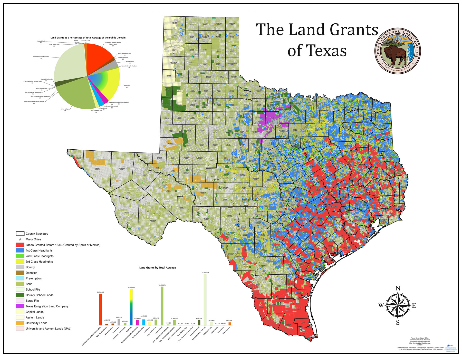
Map created by GLO GIS division to show what type of land grant created each original land survey in Texas.
Part of: General Map Collection
Tyler County Rolled Sketch 9

Print $20.00
- Digital $50.00
Tyler County Rolled Sketch 9
Size 43.3 x 25.6 inches
Map/Doc 8059
Real County Working Sketch 38

Print $20.00
- Digital $50.00
Real County Working Sketch 38
1951
Size 34.0 x 37.9 inches
Map/Doc 71930
Webb County Rolled Sketch 63

Print $20.00
- Digital $50.00
Webb County Rolled Sketch 63
1948
Size 39.4 x 37.0 inches
Map/Doc 10129
Le Nouveau Mexique appelé aussi Nouvelle Grenade et Marata, avec partie de Californie

Print $20.00
- Digital $50.00
Le Nouveau Mexique appelé aussi Nouvelle Grenade et Marata, avec partie de Californie
1687
Size 21.5 x 25.5 inches
Map/Doc 96630
Coke County Sketch File 4

Print $46.00
- Digital $50.00
Coke County Sketch File 4
1884
Size 9.2 x 7.7 inches
Map/Doc 18566
Travis County Sketch File 56

Print $6.00
- Digital $50.00
Travis County Sketch File 56
1945
Size 14.2 x 9.0 inches
Map/Doc 38398

Runnels County Working Sketch 4

Print $20.00
- Digital $50.00
Runnels County Working Sketch 4
1906
Size 15.1 x 19.3 inches
Map/Doc 63600
Harrison County Working Sketch 31

Print $40.00
- Digital $50.00
Harrison County Working Sketch 31
2006
Size 48.0 x 50.2 inches
Map/Doc 87148
Flight Mission No. DAG-14K, Frame 145, Matagorda County

Print $20.00
- Digital $50.00
Flight Mission No. DAG-14K, Frame 145, Matagorda County
1952
Size 18.6 x 22.6 inches
Map/Doc 86312
Controlled Mosaic by Jack Amman Photogrammetric Engineers, Inc - Sheet 48

Print $20.00
- Digital $50.00
Controlled Mosaic by Jack Amman Photogrammetric Engineers, Inc - Sheet 48
1954
Size 20.0 x 24.0 inches
Map/Doc 83507
Flight Mission No. DCL-7C, Frame 111, Kenedy County

Print $20.00
- Digital $50.00
Flight Mission No. DCL-7C, Frame 111, Kenedy County
1943
Size 18.5 x 22.3 inches
Map/Doc 86076
You may also like
Reeves County Boundary File 81 1/2

Print $54.00
- Digital $50.00
Reeves County Boundary File 81 1/2
Size 9.7 x 8.3 inches
Map/Doc 58216
Map of Zapata County

Print $20.00
- Digital $50.00
Map of Zapata County
1880
Size 27.1 x 25.7 inches
Map/Doc 4177
Winkler County Working Sketch 10

Print $40.00
- Digital $50.00
Winkler County Working Sketch 10
1960
Size 30.3 x 61.0 inches
Map/Doc 72604
Flight Mission No. BRA-7M, Frame 190, Jefferson County

Print $20.00
- Digital $50.00
Flight Mission No. BRA-7M, Frame 190, Jefferson County
1953
Size 18.7 x 22.3 inches
Map/Doc 85558
Huntsville State Park

Print $20.00
- Digital $50.00
Huntsville State Park
1937
Size 24.1 x 34.8 inches
Map/Doc 2077

Young County Sketch File 14

Print $20.00
- Digital $50.00
Young County Sketch File 14
1895
Size 10.9 x 27.3 inches
Map/Doc 12712
Sherman County, Texas

Print $20.00
- Digital $50.00
Sherman County, Texas
1888
Size 23.1 x 18.5 inches
Map/Doc 754
Map of Blocks No. 46 and 47 made in the name of Houston and Texas Central RR. Co. in Oldham District

Print $20.00
- Digital $50.00
Map of Blocks No. 46 and 47 made in the name of Houston and Texas Central RR. Co. in Oldham District
1884
Size 40.8 x 27.0 inches
Map/Doc 91818
Travis County Working Sketch 48

Print $40.00
- Digital $50.00
Travis County Working Sketch 48
1981
Size 53.7 x 40.3 inches
Map/Doc 69432
Plat Showing Parts of Blocks X, Y, and Z, W.D. and F. W. Johnson Subdivision

Print $20.00
- Digital $50.00
Plat Showing Parts of Blocks X, Y, and Z, W.D. and F. W. Johnson Subdivision
1955
Size 25.7 x 16.5 inches
Map/Doc 92501
Flight Mission No. DAH-10M, Frame 45, Orange County

Print $20.00
- Digital $50.00
Flight Mission No. DAH-10M, Frame 45, Orange County
1953
Size 18.8 x 22.5 inches
Map/Doc 86880